Shahdad
Shahdad
شهداد | |
|---|---|
City | |
 Haj Mohammad Taghi Ab Anbar | |
 Shahdad | |
| Coordinates: 30°25′03″N 57°42′24″E / 30.41750°N 57.70667°ECoordinates: 30°25′03″N 57°42′24″E / 30.41750°N 57.70667°E | |
| Country | |
| Province | Kerman |
| County | Kerman |
| Bakhsh | Shahdad |
| Population (2016 Census) | |
| • Total | 5,217 [1] |
| Time zone | UTC+3:30 (IRST) |
| • Summer (DST) | UTC+4:30 (IRDT) |

Shahdad (Persian: شهداد, also Romanized as Shahdād; formerly, Khabīs)[2] is a city and capital of Shahdad District, in Kerman County, Kerman Province, Iran. At the 2006 census, its population was 4,097, in 1,010 families.[3]
District[]
Shahdad is the center of Shahdad district which includes smaller cities and villages such as Sirch, Anduhjerd, Chahar Farsakh, Go-diz, Keshit, Ibrahim Abad, Joshan and Dehseif.
The driving distance from Kerman city to Shahdad is 95 km. The local climate is hot and dry. The main agricultural produce is date fruits.
There are many castles and caravanserais at Shahdad and around. Examples are the Shafee Abaad castle and the Godeez castle.
The shrine of Imam Zadeh Zeyd, in the south of the town, is a respected religious site.
Climate[]
Shahdad has a hot desert climate (Köppen climate classification BWh). The city is located at the edge of the Lut desert, which is one of the hottest an driest places in the world. The Summers are long and extremely hot, while the winter are short and mild.
| Climate data for Shahdad 400m (2003–2010) | |||||||||||||
|---|---|---|---|---|---|---|---|---|---|---|---|---|---|
| Month | Jan | Feb | Mar | Apr | May | Jun | Jul | Aug | Sep | Oct | Nov | Dec | Year |
| Average high °C (°F) | 17.2 (63.0) |
22.4 (72.3) |
29.2 (84.6) |
34.5 (94.1) |
40.1 (104.2) |
44.4 (111.9) |
46.1 (115.0) |
44.1 (111.4) |
40.2 (104.4) |
34.7 (94.5) |
25.7 (78.3) |
18.8 (65.8) |
33.1 (91.6) |
| Daily mean °C (°F) | 12.4 (54.3) |
17.1 (62.8) |
23.4 (74.1) |
28.9 (84.0) |
34.5 (94.1) |
38.6 (101.5) |
40.1 (104.2) |
38.1 (100.6) |
33.9 (93.0) |
28.9 (84.0) |
20.6 (69.1) |
14.0 (57.2) |
27.5 (81.5) |
| Average low °C (°F) | 7.7 (45.9) |
11.9 (53.4) |
17.6 (63.7) |
23.3 (73.9) |
29.0 (84.2) |
32.7 (90.9) |
34.1 (93.4) |
32.0 (89.6) |
27.6 (81.7) |
23.2 (73.8) |
15.4 (59.7) |
9.3 (48.7) |
22.0 (71.6) |
| Average precipitation mm (inches) | 9.3 (0.37) |
8.3 (0.33) |
7.9 (0.31) |
0.5 (0.02) |
0.6 (0.02) |
0.0 (0.0) |
0.0 (0.0) |
0.0 (0.0) |
0.0 (0.0) |
0.0 (0.0) |
0.2 (0.01) |
3.9 (0.15) |
30.7 (1.21) |
| Average precipitation days (≥ 1.0 mm) | 2.4 | 1.9 | 1.4 | 0.1 | 0.3 | 0.0 | 0.0 | 0.0 | 0.0 | 0.0 | 0.1 | 1.0 | 7.2 |
| Average relative humidity (%) | 38 | 29 | 22 | 20 | 15 | 12 | 11 | 12 | 13 | 16 | 25 | 33 | 20 |
| Mean monthly sunshine hours | 204.6 | 203.3 | 241.2 | 250.1 | 297.1 | 329.0 | 348.6 | 343.1 | 313.3 | 297.2 | 248.3 | 221.0 | 3,296.8 |
| Source: Iran Meteorological Organization (temperatures),[4] (precipitation),[5] (humidity),[6] (days with precipitation),[7]
(sunshine)[8] | |||||||||||||
Archaeology[]
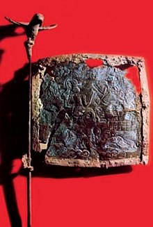
Shahdad was a major Bronze Age center discovered in 1968. Around 1970, Ali Hakemi of Archaeological Institute of Iran investigated the site. He conducted excavations for seven seasons.
"By the early third millennium B.C., Shahdad began to grow quickly as international trade with Mesopotamia expanded. Tomb excavations revealed spectacular artifacts amid stone blocks once painted in vibrant colors. These include several extraordinary, nearly life-size clay statues placed with the dead. The city's artisans worked lapis lazuli, silver, lead, turquoise, and other materials imported from as far away as eastern Afghanistan, as well as shells from the distant Persian Gulf and Indian Ocean. Evidence shows that ancient Shahdad had a large metalworking industry by this time."[9]
Shahdad shares many parallels with Shahr-i-Sokhta. Many other ancient settlements are found in what is now empty desert. According to Iranian archaeologist Hassan Fazeli Nashli, some 900 Bronze Age sites have been documented in the Sistan Basin between Afghanistan and Pakistan.
North of town, a Jiroft Civilization village is said to have existed around 6,000 BC[[[Category:Articles with specifically marked weasel-worded phrases from November 2021]][by whom?]]. The legendary Aratta of the Sumerian sources may have been located in this area.
The oldest known metal flag in human history was found in this city.
References[]
- ^ "Statistical Center of Iran > Home".
- ^ Shahdad can be found at GEOnet Names Server, at this link, by opening the Advanced Search box, entering "-3083959" in the "Unique Feature Id" form, and clicking on "Search Database".
- ^ "Census of the Islamic Republic of Iran, 1385 (2006)" (Excel). Statistical Center of Iran. Archived from the original on 2011-11-11.
- ^
- "Average Maximum temperature in Shahdad by Month 2003–2010". Iran Meteorological Organization. Archived from the original on March 11, 2016. Retrieved April 8, 2015.CS1 maint: bot: original URL status unknown (link)
- "Average Mean Daily temperature in Shahdad by Month 2003–2010". Iran Meteorological Organization. Archived from the original on March 11, 2016. Retrieved April 8, 2015.CS1 maint: bot: original URL status unknown (link)
- "Average Minimum temperature in Shahdad by Month 2003–2010". Iran Meteorological Organization. Archived from the original on March 11, 2016. Retrieved April 8, 2015.CS1 maint: bot: original URL status unknown (link)
- ^ "Monthly Total Precipitation in Shahdad by Month 2003–2010". Iran Meteorological Organization. Archived from the original on March 11, 2016. Retrieved April 8, 2015.CS1 maint: bot: original URL status unknown (link)
- ^ "Average relative humidity in Shahdad by Month 2003–2010". Iran Meteorological Organization. Archived from the original on March 11, 2016. Retrieved April 8, 2015.CS1 maint: bot: original URL status unknown (link)
- ^ "No. Of days with precipitation equal to or greater than 1 mm in Shahdad by Month 2003–2010". Iran Meteorological Organization. Archived from the original on March 11, 2016. Retrieved April 8, 2015.CS1 maint: bot: original URL status unknown (link)
- ^ "Monthly total sunshine hours in Shahdad by Month 2003–2010". Iran Meteorological Organization. Retrieved April 8, 2015.
- ^ Andrew Lawler, The World in Between Volume 64 Number 6, November/December 2011 archaeology.org
External links[]
| Wikimedia Commons has media related to Shahdad. |
| Capital |
|  | |||||||||||||||||||||||||||||||||||||||||||||
|---|---|---|---|---|---|---|---|---|---|---|---|---|---|---|---|---|---|---|---|---|---|---|---|---|---|---|---|---|---|---|---|---|---|---|---|---|---|---|---|---|---|---|---|---|---|---|---|
| Counties and cities |
| ||||||||||||||||||||||||||||||||||||||||||||||
| Sights |
| ||||||||||||||||||||||||||||||||||||||||||||||
| Places | |||||||||||||||||||||||||||||||||||||||||||||||
| Capital |
| ||||||||||||||||||||||||||||||||||||||||||||||||||||||||||||||||||||
|---|---|---|---|---|---|---|---|---|---|---|---|---|---|---|---|---|---|---|---|---|---|---|---|---|---|---|---|---|---|---|---|---|---|---|---|---|---|---|---|---|---|---|---|---|---|---|---|---|---|---|---|---|---|---|---|---|---|---|---|---|---|---|---|---|---|---|---|---|---|
| Districts |
| ||||||||||||||||||||||||||||||||||||||||||||||||||||||||||||||||||||
- Populated places in Kerman County
- Cities in Kerman Province