Shalkani
This article needs additional citations for verification. (May 2014) |
Shalkani
 | |
|---|---|
 | |
| Country | Pakistan |
| Province | Pukhtunkhwa |
| Union Council | Shalpalam |
| Houses | 450 |
| Language | Pashto (100%) |
| Religion | Islam (100%) |
| Area | |
| • Total | 6 km2 (2 sq mi) |
| Population (1998) | |
| • Total | 3,000 |
| Time zone | PST |
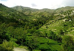
The Shalkani (Urdu: شلکنی) is a village in northern Khyber Pakhtunkhwa, northwestern Pakistan. Shalkani is located approximately at 6 km distance from Peshawar to Dir GT Road.[1]
Location[]
Shalkani is located on the left side of Panjkoora River, about 26 kilometers from Timergara. To the north side of Shalkani Jelar Dara is located, to the south is , to the east is Akhagram and to the west is Luqman Banda, and Shalkani is located as a small valley in center of them.[2]
Education[]
Following is the list of schools in Shalkani.
| School | Boys | Girls |
|---|---|---|
| High | 1 | 0 |
| Middle | 1 | 0 |
| Primary | 2 | 1 |
| Maktab | 2 | 2 |
Facilities[]
This section is empty. You can help by . (May 2014) |
See also[]
References[]
- ^ Fazlul Haq; et al. "Handling The Scarce Mountains' Resources: Role Of Indigenous Tenure Arrangements In Land Management In Roghani Valley Northern Pakistan". University of Peshawar.
- ^ "Fazli Haq M.Phil Map on Wikimapia".
Categories:
- Populated places in Malakand District