Shimoji-shima
show This article may be expanded with text translated from the corresponding article in Japanese. (January 2021) Click [show] for important translation instructions. |
Native name: Shimoji-shima (下地島) | |
|---|---|
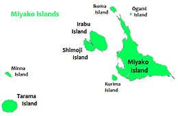 Shimoji Island is to the west of Miyako Island | |
| Geography | |
| Location | Okinawa Prefecture |
| Coordinates | 24°48′58″N 125°9′25″E / 24.81611°N 125.15694°E |
| Archipelago | Miyako Islands |
| Area | 9.68 km2 (3.74 sq mi)[1] |
| Highest elevation | 21.6 m (70.9 ft) |
| Administration | |
| Prefecture | Okinawa Prefecture |
| Demographics | |
| Population | 76 (2015 national census)[1] |
| Ethnic groups | Ryukyuan, Japanese |

View of Shimojijima Airport on Shimoji Island
Shimoji-shima (下地島), (Miyako: Sïmuzï) is one of the Miyako Islands, a part of the Ryukyu Islands. The island is administered by Miyakojima, Okinawa Prefecture, Japan. The island is connected to Irabu Island via Nakaji Bridge (仲地橋).[1]
Shimoji-shima is included within the Irabu Prefectural Natural Park and is the main setting for the anime series Stratos 4.
Shimojishima Airport is located on the island.
See also[]
References[]
- ^ Jump up to: a b c "Remote island related materials (離 島 関 係 資 料)" (PDF). Archived (PDF) from the original on 2020-02-15. Retrieved 2020-02-15.
| show Authority control |
|---|
Coordinates: 24°49′08″N 125°09′14″E / 24.819°N 125.154°E
This Okinawa Prefecture location article is a stub. You can help Wikipedia by . |
Categories:
- Miyako Islands
- Islands of Okinawa Prefecture
- Okinawa geography stubs