Shrewsbury River
| Shrewsbury River | |
|---|---|
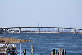 The downstream section of the Shrewsbury River, with the Highlands – Sea Bright Bridge and the island of Manhattan in the background. | |
 Shrewsbury River | |
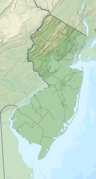
| Location | New Jersey |
| Coordinates | 40°20′27″N 74°00′10″W / 40.340741°N 74.002641°WCoordinates: 40°20′27″N 74°00′10″W / 40.340741°N 74.002641°W |
| Type | Estuary |

The Shrewsbury River is a short stream and navigable estuary, approximately 8 mi (13 km) long, in central New Jersey in the United States.
It extends ENE from its head of navigation at Oceanport to its confluence with the Navesink River estuary, then entering 1 mi (1.6 km) north in a narrow channel to Sandy Hook Bay at Highlands. The south shore runs about the entire length of the northern border of Long Branch. The estuary is protected from the open Atlantic Ocean on its eastern side by a long barrier peninsula that extends north to become Sandy Hook. Jersey Shore resort communities on the peninsula include Monmouth Beach and Sea Bright. On the inner side of the estuary, the bedroom community of Rumson on the end of the peninsula, separating the Shrewsbury and Navesink estuaries, is among the wealthiest communities in the United States.
The estuary provides a popular marina for pleasure craft and recreational fishing. Marine species like Fluke (summer flounder), striped bass, bluefish and weakfish are popular fish targeted by local anglers.
Tributaries[]

Bridges[]
- Capt. Joseph Azzolina Memorial Bridge
- Bascule Bridge
- Gooseneck Point Bridge
Marinas[]
- Anglers Marina
- Bakers Landing Marina
- Channel Club Marina
- Gateway Marina
- Long Branch Ice Boat & Yacht Club
- Oceanport Landing
- Navesink Marina
- Patten Point Yacht Club
- Pleasure Bay Yacht Basin
See also[]
- List of New Jersey rivers
- Navesink River
- Raritan River
- Raritan Bay
- Lower New York Bay
External links[]
This Monmouth County, New Jersey state location article is a stub. You can help Wikipedia by . |
- Rivers of New Jersey
- Rivers of Monmouth County, New Jersey
- Monmouth County, New Jersey geography stubs
- New Jersey river stubs