Shuteye Peak
| Shuteye Peak | |
|---|---|
 The Shuteye Peak Lookout tower in the Sierra National Forest. | |
| Highest point | |
| Elevation | 7,544 ft (2,299 m) NAVD 88[1] |
| Prominence | 1,311 ft (400 m)[1] |
| Coordinates | 37°20′57″N 119°25′36″W / 37.349167°N 119.426667°WCoordinates: 37°20′57″N 119°25′36″W / 37.349167°N 119.426667°W |
| Geography | |
 Shuteye Peak | |
| Location | Sierra National Forest, Madera County, California, U.S. |
| Parent range | Sierra Nevada |
| Topo map | USGS Shuteye Peak, CA |
| Climbing | |
| Easiest route | Trail hike (class 1) |


Shuteye Peak is a mountain located in the Sierra National Forest in Madera County, California.
Shuteye Peak is known for its panoramic views of the San Joaquin Valley, Mammoth Mountain, Bass Lake, and North Fork areas and is home to one of the last active fire lookouts in California.
The peak is accessible by a main trailhead which begins north of Central Camp used by the United States Forest Service to supply the Shuteye Peak Fire Lookout by off-road vehicle and is popular with hikers and mountain bikers in the summer months. The trail is steep and technical with many exposed rock sections of quartz monzonite.[2][3]
Fire Lookout[]
Shuteye Lookout was established and put into service by the U.S. Forest Service in 1907. The current structure was built in 1957 featuring a 14' x 14' foot steel cab with a flat roof standing on a 10' x 10' foot concrete block base. A weather station was added in 2012.[4] Shuteye remains one of the few active lookouts in the Sierra Nevada. In 2017, Richard Bushnell, a seasonal U.S. Forest Service employee, was among the first to spot the Railroad Fire while stationed on Shuteye Peak.[5]

Forest Service Memorial[]
Six bronze plaques honoring early pioneers of the United States Forest Service are mounted near the summit on a large granite outcropping known as Pancake Rock. The plaques were installed by Walter Puhn, the National Forest Supervisor, for which the Old Forester tree in Nelder Grove is named.[6]

Maurice A. Benedict ran the Sierra National Forest as Forest Supervisor from 1916-1944.
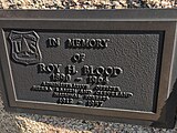
Roy H. Blood served as a forester for 40 years.

Chester E. Jordan was a Ranger Supervisor Inspector and District Ranger.
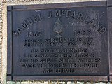
Samuel J. McFarland was the lookout at Shuteye Peak from 1925-1929; his remains are interred below the plaque.

Eugene Tully regulated grazing in the Sierra National Forest in 1903.
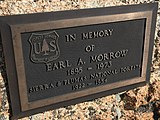
Earl A. Morrow served in the Sierra and Plumas National Forests from 1922-1954.


Ecology[]
Shuteye Peaks' upper montane and subalpine forest is the only known habitat of the Shuteye Peak fawn lily which is listed as an endangered species by the California Department of Fish and Wildlife.[7]
References[]
- ^ a b "Shuteye Peak, California". Peakbagger.com.
- ^ Huber, N. King. "Shuteye Peak Quadrangle, Sierra Nevada, California" (PDF). United States Geological Survey. Retrieved 23 December 2020.
- ^ "Shuteye Peak OHV - 6S59". Trailforks. Retrieved 23 December 2020.
- ^ "Shuteye Peak Fire Lookout". Fire-Lookouts.org. Retrieved 23 December 2020.
- ^ Sebastian, Debbie (October 10, 2017). "The Sierra Star". Retrieved 23 December 2020.
- ^ Negley, Brenda L. (2016). Nelder Grove of Giant Sequoias: A Granddaughter’s Stories. Otter Bay Books. p. 63. ISBN 978-0-578-18029-8.
- ^ "Critically Imperiled Plant Profile (Not Listed or Proposed under the Endangered Species Act)". United States Department of Agriculture.
This Madera County, California-related article is a stub. You can help Wikipedia by . |
- Mountains of Madera County, California
- Sierra National Forest
- Mountains of the Sierra Nevada (United States)
- Mountains of Northern California
- Fire lookout towers
- Madera County, California geography stubs