Siegen-Wittgenstein
Siegen-Wittgenstein | |
|---|---|
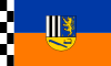 Flag  Coat of arms | |
 | |
| Country | Germany |
| State | North Rhine-Westphalia |
| Adm. region | Arnsberg |
| Capital | Siegen |
| Area | |
| • Total | 1,131.47 km2 (436.86 sq mi) |
| Population (31 December 2020)[1] | |
| • Total | 275,491 |
| • Density | 240/km2 (630/sq mi) |
| Time zone | UTC+01:00 (CET) |
| • Summer (DST) | UTC+02:00 (CEST) |
| Vehicle registration | SI |
| Website | siegen-wittgenstein.de |
County of Wittgenstein Grafschaft Wittgenstein | |||||||
|---|---|---|---|---|---|---|---|
| 1174–1357 | |||||||
 Coat of arms of the Counts of Wittgenstein
| |||||||
| Status | Grafschaft (County) (State of the Holy Roman Empire) | ||||||
| Capital | Wittgenstein Castle | ||||||
| Government | County | ||||||
| Historical era | Middle Ages | ||||||
• Established | 1174 | ||||||
• Merged with | 1357 | ||||||
| |||||||
Siegen-Wittgenstein is a Kreis (district) in the southeast of North Rhine-Westphalia, Germany. Neighboring districts are Olpe, Hochsauerlandkreis, Waldeck-Frankenberg, Marburg-Biedenkopf, Lahn-Dill, Westerwaldkreis, and Altenkirchen.
History[]
In 1816–1817, the two districts of Siegen and Wittgenstein were created as parts of the Prussian province of Westphalia. In 1974, the two districts were merged, and in 1984 the name Siegen-Wittgenstein was adopted.
Geography[]
Geographically, it covers the hills southeast of the Sauerland hills, the Siegerland and Wittgensteiner Land.
Coat of arms[]
The two upper sections show, to the right, the arms of the Dukes of Nassau, who founded Siegen, and to the left, those of the Counts of Sayn-Wittgenstein. At the bottom a miner's lamp and a coppicing hook are depicted, in reference to the mining and charcoal-burning history of the district.
Towns and municipalities[]

- Municipalities
References[]
- ^ "Bevölkerung der Gemeinden Nordrhein-Westfalens am 31. Dezember 2020" (in German). Landesbetrieb Information und Technik NRW. Retrieved 21 June 2021.
External links[]
 Media related to Kreis Siegen-Wittgenstein at Wikimedia Commons
- Official webpage (in German)
- History and genealogy for Wittgenstein
Coordinates: 50°55′N 8°10′E / 50.92°N 8.17°E
| hide | ||
|---|---|---|
| Urban districts |  | |
| Rural districts |
| |
Districts of German states (Full list)
| ||
| show Authority control |
|---|
This Siegen-Wittgenstein district location article is a stub. You can help Wikipedia by . |
- Districts of North Rhine-Westphalia
- Siegen-Wittgenstein
- 1357 disestablishments in Europe
- States and territories established in 1174
- Siegerland
- Counties of the Holy Roman Empire
- Arnsberg region geography stubs