Steinfurt (district)
Steinfurt | |
|---|---|
 Flag 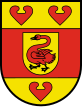 Coat of arms | |
 | |
| Country | Germany |
| State | North Rhine-Westphalia |
| Adm. region | Münster |
| Capital | Steinfurt |
| Government | |
| • District admin. | Dr. Klaus Effing (CDU) |
| Area | |
| • Total | 1,792.097 km2 (691.933 sq mi) |
| Population (31 December 2020)[1] | |
| • Total | 448,197 |
| • Density | 250/km2 (650/sq mi) |
| Time zone | UTC+01:00 (CET) |
| • Summer (DST) | UTC+02:00 (CEST) |
| Vehicle registration | ST, TE, BF |
| Website | http://www.kreis-steinfurt.de |
Steinfurt (German pronunciation: [ˈʃtaɪ̯nˌfʊʁt] (![]() listen)) is a Kreis (district) in the northern part of North Rhine-Westphalia, Germany. Neighboring districts are Bentheim, Emsland, district-free Osnabrück and the Osnabrück district, Warendorf, district-free Münster, Coesfeld, Borken.
listen)) is a Kreis (district) in the northern part of North Rhine-Westphalia, Germany. Neighboring districts are Bentheim, Emsland, district-free Osnabrück and the Osnabrück district, Warendorf, district-free Münster, Coesfeld, Borken.
Geography[]
The district is situated at the Lower Saxon border, north of Münster. The Ems river runs through the district from south to north. The highest point in the region is the Westerbecker Berg at 234 metres above sea level; the lowest point is Bentlage Castle at 32 metres.
History[]
In late medieval times Steinfurt became an independent earldom. Originally it was a part of the earldom of Bentheim, before it became independent in 1454. In 1804 Steinfurt was reunited with Bentheim, before it became a part of the Prussian province of Westphalia in 1815. The new government in 1816 created the districts Steinfurt and Tecklenburg.
In 1975, the old district Steinfurt was merged with the district Tecklenburg, and together with Greven and Saerbeck from the former district Münster the current district was formed.
Coat of arms[]
The coat of arms combines elements from the coats of arms of the former districts of Steinfurt, Tecklenburg and Münster. The swan in the middle comes from the countship of Steinfurt, the centre of the district. The red bar around the swan symbolizes the clerical state of Münster, which lay around the dukedom of Steinfurt. The red water lily leaves were symbols of the dukes of Tecklenburg.
Towns and municipalities[]

| Towns | Municipalities | |
|---|---|---|
Town Twinning[]
Steinfurt is twinned with:
References[]
- ^ "Bevölkerung der Gemeinden Nordrhein-Westfalens am 31. Dezember 2020" (in German). Landesbetrieb Information und Technik NRW. Retrieved 21 June 2021.
- ^ Ealing Council.Twinning. Accessed 2008-09-19
External links[]
![]() Media related to Kreis Steinfurt at Wikimedia Commons
Media related to Kreis Steinfurt at Wikimedia Commons
| hide | ||
|---|---|---|
| Urban districts |  | |
| Rural districts |
| |
Districts of German states (Full list)
| ||
| show Authority control |
|---|

- Districts of North Rhine-Westphalia
- Steinfurt (district)