Sieraków
Sieraków | |
|---|---|
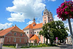 Church of the Immaculate Conception of the Virgin Mary and the Bernardine monastery | |
 Flag  Coat of arms | |
 Sieraków | |
| Coordinates: 52°39′0″N 16°6′0″E / 52.65000°N 16.10000°ECoordinates: 52°39′0″N 16°6′0″E / 52.65000°N 16.10000°E | |
| Country | |
| Voivodeship | |
| County | Międzychód |
| Gmina | Sieraków |
| Established | 13th century |
| Town rights | before 1388 |
| Government | |
| • Mayor | Witold Bruno Maciołek |
| Area | |
| • Total | 14.1 km2 (5.4 sq mi) |
| Elevation | 31 m (102 ft) |
| Population (2012) | |
| • Total | 8,768 |
| • Density | 620/km2 (1,600/sq mi) |
| Time zone | UTC+1 (CET) |
| • Summer (DST) | UTC+2 (CEST) |
| Postal code | 64-410 |
| Area code(s) | +48 61 |
| Car plates | PMI |
| Website | http://www.sierakow.pl |


Sieraków (Polish pronunciation: [ɕɛˈrakuf]; German: Zirke) is a town in western Poland with 8,768 inhabitants (2012). Located by the Warta River, it has been situated in the Greater Poland Voivodeship (since 1999), previously in Poznań Voivodeship (1975–1998). Sieraków is known as a holiday destination with well-developed tourism and sport infrastructure. It is surrounded by extensive areas of forest and lakes, including the protected area called Sieraków Landscape Park.
History[]
During the Second Partition of Poland in 1793, Sieraków, under its Germanized name Zirke was annexed by the Kingdom of Prussia. In 1871, it also became part of Germany and was located in the Birnbaum district in the Prussian Province of Posen. According to the census of 1871, the town had a population of 2,527, of which 1,130 (44.7%) were Poles.[1]
The town was captured by Polish insurgents in the Greater Poland uprising in 1919 and was subsequently assigned to the Second Polish Republic through the Treaty of Versailles. During World War II in 1939, the town was occupied by Nazi Germany and was annexed as part of the Birnbaum district in Reichsgau Wartheland. Towards the end of the war in 1945, it was captured by the Red Army and was restored to Poland.
Notable residents[]
- Lewis Naphtali Dembitz (1833–1907), German American legal scholar
- Hartmut Neugebauer (1942-2017) German actor and voice actor
- Krzysztof Opaliński (1611-1655), Polish nobleman and political satirist
Gallery[]

Sieraków castle

The Opaliński family sarcophagus in castle's basement

Zamkowa "Castle" street


See also[]
External links[]
| Wikimedia Commons has media related to Sieraków. |
- Sierakow official web page (in Polish)
- Parish of Sierakow official web page (in Polish)
- TKKF
- Discussion forum
Major corporations[]
References[]
- ^ Neumann, Gustav (1874). Das Deutsche Reich in geographischer, statistischer und topographischer Beziehung (in German). Müller.
| hide | ||
|---|---|---|
| Town and seat |  | |
| Villages | ||
| show Authority control |
|---|
This Międzychód County location article is a stub. You can help Wikipedia by . |
- Cities and towns in Greater Poland Voivodeship
- Międzychód County
- Poznań Voivodeship (1921–1939)
- Międzychód County geography stubs