Sirník
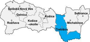
Location of Trebišov District in the region.
Sirník (Hungarian: Szürnyeg) is a village and municipality in the Trebišov District in the Košice Region of south-eastern Slovakia.
History[]
In historical records the village was first mentioned in 1403.
Geography[]
The village lies at an altitude of 128 metres and covers an area of 5.822 km². It has a population of about 605 people.
Ethnicity[]
The village is about 71% Slovak, 25% Hungarian and 4% Gypsy.
Facilities[]
The village has a public library.
External links[]
- http://www.statistics.sk/mosmis/eng/run.html
- http://picasaweb.google.com/zfp.kch/SirnKSzRnyeg6102007[permanent dead link]
Coordinates: 48°31′N 21°49′E / 48.517°N 21.817°E

This article relating to the geography of the Trebišov District is a stub. You can help Wikipedia by . |
Categories:
- Villages and municipalities in Trebišov District
- Trebišov District geography stubs