Skyway
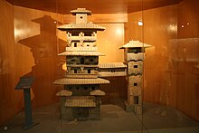 A Han Dynasty (202 BC – 220 AD) Chinese miniature model of two residential towers joined by a skyway |
 |
A skyway, skybridge, or skywalk is an elevated type of pedway connecting two or more buildings in an urban area, or connecting elevated points within mountainous recreational zones. Urban skyways very often take the form of enclosed or covered footbridges that protect pedestrians from the weather. Open-top modern skyways in mountains now often have glass bottoms. Sometimes enclosed urban skywalks are made almost totally from glass, including ceilings, walls and floors. Also, some urban skyways function strictly as linear parks designed for walking.
In North America skyways are usually owned by businesses, and are therefore not public spaces (compare with sidewalk). However, in Asia, such as Bangkok's and Hong Kong's skywalks, they are built and owned separately by the city government, connecting between privately run rail stations or other transport with their own footbridges, and run many kilometers. Skyways usually connect on the first few floors above the ground-level floor, though they are sometimes much higher, as in Petronas Towers. The space in the buildings connected by skyways is often devoted to retail business, so areas around the skyway may operate as a shopping mall. Non-commercial areas with closely associated buildings, such as university campuses, can often have skyways and/or tunnels connecting buildings.
The world's largest discontinuous skyway network – Calgary, Alberta, Canada's "+15 Walkway" system – has a total length of 18 km (11 mi). The Minneapolis Skyway System is the world's largest continuous system and spans 11 miles (18 km) connecting 80 blocks in downtown Minneapolis, Minnesota, United States.
On a smaller scale, terminals of large airports are often connected by skywalk systems, as at Manchester Airport, United Kingdom; in many airports, retractable jet bridges provide a direct connection between airplanes and terminals.
Some cities have the equivalent of a skyway underground, and there are also mixed subway/skyway systems; see underground city.
Early examples[]
- Florence, Italy, Vasari Corridor, connects Palazzo Vecchio to Uffizi and then to Palazzo Pitti, 16th century
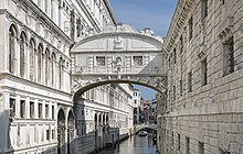
- Venice, Italy, Bridge of Sighs, connects Doge's Palace and prison, 16th century
- Copenhagen, Denmark: skywalk connecting courts building to adjacent uses, 18th century
- Faaborg, Funen, Denmark: skywalk in centrum, 18th century
Environmental factors[]
Besides pedestrian safety and convenience, the chief reasons assigned by urban planners for skywalk development are decrease of traffic congestion, reduction in vehicular air pollution and separation of people from vehicular noise. A number of cities (for example, Spokane, Washington) have given intricate analysis to skywalk systems employing computer models to optimize skywalk layout.[1]
Negative impacts[]
There is debate about the negative impact on urban areas of skyways. Robertson (1988) noted the negative impacts to street activities, and reductions to the property value at ground level.[2] Woo (2012) found that skywalk systems could be negatively associated with promoting consumerism.[3] Cui (2015) called for more research into the impact of skyways in developing countries.[4]
Cities with notable systems[]
North America[]
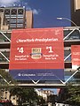
There are significant skyway networks in many cities in the US Midwest, such as Minneapolis, Saint Paul, Des Moines, Cedar Rapids, Rochester, Cincinnati, and Duluth.[5] Most networks in North America are privately owned. Notable exceptions are skyways in Saint Paul and in New York (High Line), which are publicly owned.[6]
| City | System | Length | Blocks connected | Link |
|---|---|---|---|---|
| Atlanta, Georgia | Peachtree Center | 14 blocks | map | |
| Calgary, Alberta | +15, +30, or +45 Walkway | 18 km (11 miles)[7] | ~64 blocks | map |
| Cedar Rapids, Iowa | 15 blocks | map | ||
| Chicago, Illinois | Chicago Pedway | 40 blocks | ||
| Cincinnati, Ohio | Cincinnati Skywalk | 1.3 miles (2.1 km) | 15 blocks | map |
| Dallas, Texas | Dallas Pedestrian Network | 3 miles (4.8 km) | 36 blocks, in two separate networks | map |
| Des Moines, Iowa | Skywalk | 4 miles (6.4 km)[8] | 30 blocks | map |
| Detroit, Michigan | 10 buildings, ~ 8 blocks | map | ||
| Duluth, Minnesota | Skywalk | 3 miles (4.8 km)[9] | ~17 blocks | map |
| Edmonton, Alberta | Edmonton Pedway | 13 kilometres (8.1 mi) | ~13 blocks | map |
| Fargo, North Dakota | 6 blocks | |||
| Grand Rapids, Michigan | Skywalk | > 1 mile (1.7 km) | 7 blocks – connects 12,000-seat VanAndel Arena, JW Marriott, Amway Grand Plaza and Marriott Courtyard hotels as well as 1,000,000 sq ft (93,000 m2) DeVos Place Convention Center | map |
| Halifax, Nova Scotia, Canada | Downtown Halifax Link | |||
| Houston, Texas | Houston Downtown Tunnel System | > 6 miles (9.7 km) including tunnels | ~35 blocks (95 total) | map |
| Indianapolis, Indiana | Indianapolis Skywalk | Connects the Indiana Convention Center, Indianapolis Artsgarden, Lucas Oil Stadium, Circle Centre Mall, Indianapolis Union Station, JW Marriott Indianapolis, and 11 other hotels.[10] | map | |
| Kansas City, Missouri | Crown Center | |||
| Las Vegas Strip | Skyways are provided in lieu of street level pedestrian crossings | |||
| Lincoln, Nebraska | 7 blocks | |||
| Louisville, Kentucky | Louie Link | A glassed-in skywalk called the Louie Link stretches six city blocks and links together the Kentucky International Convention Center (KICC), Fourth Street Live!, three hotels (Galt House Hotel & Suites, Marriott and Hyatt Regency), and 2,300 hotel rooms. In 2010 it was extended from the Galt House to the new $16 million Skywalk Garage, an eight-level, 860-space parking facility on Third Street, and a second skywalk connects from the garage across Third Street to the new KFC Yum! Center | map | |
| Mankato, Minnesota | City Center Campus | ~ 0.5 miles (0.80 km) | 8 blocks | |
| Milwaukee, Wisconsin | Empire Building, Chase Tower, Grand Avenue Mall, Federal Building, Hyatt Regency, Hilton, Wisconsin Center | |||
| Minneapolis, Minnesota | Minneapolis Skyway System | > 11 miles (18 km) | ~80 blocks | map |
| New York | High Line | > 1.45 miles (2.33 km) | The pedestrian skyway and linear park on 10 m height on former elevated railway | map |
| New York | Hunter College | 3 blocks | ||
| Oklahoma City, Oklahoma | Oklahoma City Underground | ~30 buildings | ||
| Pittsburgh, Pennsylvania | 16 blocks | map | ||
| Rochester, Minnesota | Skyway | ~17 blocks | map | |
| Rochester, New York | 20 buildings over 13 blocks | map | ||
| Saint Paul, Minnesota | Skyway | > 5 miles (8.0 km) | 30 blocks | map |
| Sioux City, Iowa | 13 blocks | map | ||
| Spokane, Washington | 16 blocks | |||
| Toronto, Ontario | SkyWalk | 0.7 km | 2 blocks – Metro Toronto Convention Centre South Building and Union Station (Toronto) | |
| Winnipeg, Manitoba | Winnipeg Walkway | 18 blocks |
Asia[]
The highest cantilevered skybridge between separate buildings in the world now placed in local Raffles City skyscrapers complex in Chongqing, China. World longest 430-meters pedestrian hanging skywalk Zhangjiajie Glass Bridge between mountain peaks also situated in China.
The highest cantilevered skybridge as construction element of building exist atop of Kingdom Centre in Riyadh, Saudi Arabia.
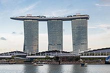
One of the most famous similar cantilevered skybridges, that looks like uppered[check spelling] ship from the bird's-eye and submarine from the ground, known in Singapore's Marina Bay Sands resort complex of skyscrapers.
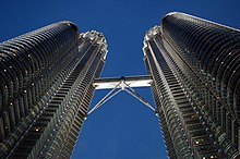
Also wide known the world's highest 2-story skybridge, 170 m above the ground and 58 m long, between the two towers on 41st and 42nd floors in Petronas Twin Towers dual skyscrapers in Kuala Lumpur, Malaysia. Malaysia also have the mountainarian tourist pedestrian glass-bottom Langkawi Sky Bridge in Kedah, Langkawi.
One of the most impressionable hanging pedestrian skybridges, supported by two giant hands, Golden Bridge now attracts the tourists in Ba Na Hills near Da Nang, Vietnam.
In Bangkok, Thailand there are more than 5.4 km of covered wide dedicated elevated skywalks[11] with lighting. These were developed due to lack of proper sidewalks as well as street hawkers and local merchants taking advantage of any sidewalk space as makeshift commercial real estate. Common reasons skywalks were built include to avoid street pollution, dust, wetness from food vendors and/or rain, potholes, long queues, crowds, and uneven pavement, supporting urbanism but probably most importantly, tourism receipts. Most skywalks connect to a BTS station and utilize space underneath the rail line and BTS pillar supports. These skywalks have connector ramps which connect stations to malls seamlessly and are paid for by the malls themselves, otherwise the city and BTS fund walkway development. A 50km long extension project was shelved in 2011 due to funding issues,[12] nevertheless the system is growing organically.
In Hong Kong, there are numerous foot bridge networks across the city. Particularly large networks exists around elevated or at grade MTR stations and connections between malls and housing estates in new town centers. The largest network spans Admiralty, Central and parts of Sheung Wan districts in the CBD and consists of the Central Elevated and Central–Mid-Levels Walkway systems which link up over 40 major office buildings. The Central–Mid-Levels walkway system is the longest outdoor covered escalator system in the world according to Guinness World Records.[9][10] Other large systems exist in Tsuen Wan and Mong Kok.
The Mumbai Skywalk Project, India is a discontinuous network of over 50 km of skywalks in Mumbai Metropolitan Region, India. The skyways connect Mumbai Suburban Railway stations to important junctions, each 1 to 2 km in length. The first of these is a 1.3 km (0.8 mi) long skywalk connecting the suburban regions of Bandra and Kurla.[13][14][15]
Additionally, short skyways are used to connect buildings in other Asian locations.
Europe[]
Brussels, Belgium has a skyway between the two Belgacom Towers.
London has skywalks on the Barbican Estate and London Wall. The City of London Pedway Scheme was devised as part of the post World War II reconstruction plans for London, it was put into effect mainly from the mid-1950s to the mid-1960s and eventually abandoned by the 1980s. Shad Thames has picturesque skyways between former warehouses, used in part to roll barrels between them.
The twin towers of the Highlight Towers in Munich, Germany are joined by two skyways made of glass and steel.
The Promenade Plantée in the 12th arrondissement of Paris, France includes pedestrian bridges and a linear park on an aqueduct of a former railway.
Australia[]
- Melbourne, Australia, four blocks and Airport
Gallery[]

Bridge of Sighs in Oxford

Vasari Corridor in Florence

The Bridge of Aspiration, a skybridge in Covent Garden, London
Hotel Kupa, Prague-Háje, Czechia
German Mining Museum in Bochum

Skyway in Interlaken, Switzerland
A Skyway serving as part of a café, Münster, Germany
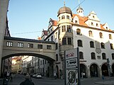
Skyway in Munich, Bavaria

A Brutalist skyway at the University of Leeds, England

An inside view of the skybridge of Petronas Towers

This skyway at London Gatwick Airport is designed to allow aircraft to pass under

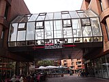
A three-storey bridge at The Core Shopping Centre in Calgary

Skyway at 6th Avenue at Pine St in Seattle
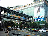
The skyway system in Taipei

Promenade Plantée in Paris
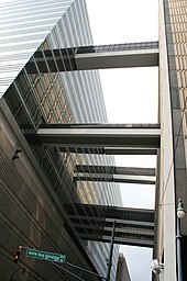
Typical urban connection over heavy traffic as seen here connecting three levels at a Hospital in New York City, USA


See also[]
- Footbridge - a bridge for pedestrians
- Overpass - a bridge, road or railway crossing over another road or railway
- Pedestrian separation structure - any structure which separates pedestrians from the roadway
- Pedway - pedestrian walkways, includes both skyways and underground walkways
- Sidewalk - pedestrian path along the side of a road
- Catwalk - a narrow footbridge or walkway to allow workers access to parts of a structure
- Hyatt Regency walkway collapse - a failure of an internal skyway
References[]
| Wikimedia Commons has media related to Skyways. |
- ^ Carbon monoxide dispersion analysis in downtown Spokane, ESL Inc., Sunnyvale, (1973)
- ^ Robertson, K. A. (1988-07-01). "PEDESTRIAN SKYWALK SYSTEMS: DOWNTOWN'S GREAT HOPE OR PATHWAYS TO RUIN?". Transportation Quarterly. 42 (3). ISSN 0278-9434.
- ^ Ares (2012-07-02). "Guest Article: Skywalks in Hong Kong and their Consequences on Urban Communities". Places. Retrieved 2016-11-05.
- ^ Cui, Jianqiang; Allan, Andrew; Lin, Dong (2015-06-03). "Assessing grade separation pedestrian systems: Planning, design and operation". Urban Design International. 20 (3): 241–252. doi:10.1057/udi.2015.8. ISSN 1357-5317. S2CID 107085967.
- ^ Montgomery, Michael R.; Bean, Richard (1999-01-01). "Market Failure, Government Failure, and the Private Supply of Public Goods: The Case of Climate-Controlled Walkway Networks". Public Choice. 99 (3–4): 403–37. doi:10.1023/a:1018301628084. ISSN 0048-5829. S2CID 59471029.
- ^ "How a small request kicked off a big debate over skyways and public safety in St. Paul". MinnPost. Retrieved 2016-11-05.
- ^ "Calgary's +15 Skywalk" (PDF).
- ^ Skywalks – Greater Des Moines Convention and Visitors Bureau. Seedesmoines.com. Retrieved on 2011-09-30.
- ^ Skywalk, Skywalk Fitness Program, Clean & Safe Team Contact. downtownduluth.com. Retrieved on 2016-04-26.
- ^ "Connected Hotels in Indianapolis". Visit Indy. Retrieved 2017-10-30.
- ^ http://www.bangkokpost.com/lite/news/420125/up-above-the-milling-crowd[bare URL]
- ^ "BMA's skywalk project 'over-priced'". 2011-03-03.
- ^ [1] Archived September 13, 2009, at the Wayback Machine
- ^ Bellman, Eric. (2010-01-19) Packed Streets Have a City of Walkers Looking Skyward for Answers. Online.wsj.com. Retrieved on 2011-09-30.
- ^ [2] Archived June 13, 2010, at the Wayback Machine
- Rooms
- Bridges
- Covered bridges
- Urban studies and planning terminology
- Pedestrian infrastructure
- Skyways