Slagelse
Slagelse | |
|---|---|
City | |
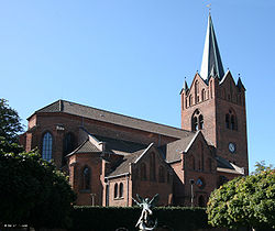 Church of Saint Michael | |
 Seal  Coat of arms | |
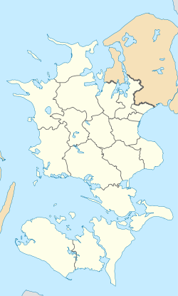 Slagelse Location in Region Zealand | |
| Coordinates: 55°24′17.5″N 11°21′11″E / 55.404861°N 11.35306°ECoordinates: 55°24′17.5″N 11°21′11″E / 55.404861°N 11.35306°E | |
| Country | Denmark |
| Region | Region Zealand |
| Municipality | Slagelse |
| Area | |
| • Urban | 16.2 km2 (6.3 sq mi) |
| Population (2021)[1] | |
| • Urban | 34,118 |
| • Urban density | 2,100/km2 (5,500/sq mi) |
| • Gender [2] | 16,691 males and 17,427 females |
| Demonym(s) | Slagelsebo, Slagelseaner |
| Time zone | UTC+1 (CET) |
| • Summer (DST) | UTC+2 (CEST) |
| Postal code | 4200 |
| Calling code | (+45) 58 |
| Website | https://www.slagelse.dk/ |

Slagelse (Danish pronunciation: [ˈslɛːjl̩sə]) is a town on Zealand, Denmark. The town is the seat of Slagelse Municipality, and is the biggest town of the municipality. It is located 15 km east of Korsør, 16 km north-east of Skælskør, 33 km south-east of Kalundborg and 14 km west of Sorø.
History[]
Slagelse has been inhabited since at least the Viking Age, where it was a Pagan site. Trelleborg, a ring castle, was built near the current location of Slagelse in 980, which made the location strategically important. A church was built at Slagelse's current location in the 1000s. Around this time, coins were minted in Slagelse.[3]
Antvorskov was built in the 1100s by Valdemar I, who had recently acquired Zealand. He built the monastery in an attempt to gain control and favor with the locals. The monastery was used by the Knights Hospitaller. [4]
Slagelse was granted the status of a market town in 1288 by Eric V. This gave the town a series of privileges, though eventually put it in competition with the neighboring market towns of Korsør and Skælskør. In the 1780s a road from Copenhagen to Korsør was built, and this road ran through Slagelse.[5]
Sights[]
Slagelse Park (Danish: Slagelse Lystanlæg) is a park located centrally in Slagelse. It is a green recreational area, with lakes, playgrounds and a maze.[6]
Slagelse Museum is located centrally in Slagelse. The museum focuses mainly on trade and artisanry. It includes a reconstruction of a shop from the 1940-1950s, as well as sections on local history. A part of the museum is dedicated to H. C. Andersen, who went to school in Slagelse.[7]
Antvorskov[]
The Antvorskov Monastery Ruins are located in southern Slagelse. They are the ruins of Antvorskov Monastery, a monastery built in 1164 by Valdemar I. It was the first Knights Hospitaller monastery in Denmark, and was used as monastery until 1536 when the crown took over ownership and turned into a castle. Frederik II used the castle between 1580-1584. After that it was used by fief lords until 1717, when it became a ryttergods - a location for the Danish cavalry. It was sold in 1774 and most of the castle was torn down in 1816.[8][9]
Notable residents[]
Public thought and politics[]
- Ludvig Stoud Platou (1778–1833), historical and geographical writer
- Georg Koës (1782–1811), philologist
- William Christopher Zeise (1789–1847), chemist
- Jørgen Peter Frederik Wulff (1808–1881), naval officer
- Anna Laursen (1845–1911), schoolteacher and women's rights activist
- Niels Erik Nørlund (1885–1981), mathematician
- Margrethe Nørlund Bohr (1890–1984), editor and transcriber for Danish physicist Neils Bohr
- Hilmar Baunsgaard (1920–1989), politician and leader of the Danish Social Liberal Party from 1968–1975
- Stén Knuth (born 1964), politician and MF
- Louise Schack Elholm (born 1977), politician and MF
- Rasmus Horn Langhoff (born 1980), politician and MF
Art[]
- Johan Jacob Bruun (1715–1789), painter
- Andrea Krætzmer (1811–1889), ballet dancer
- Didrik Frisch (1835–1867), landscape painter
- Ludvig Abelin Schou (1838–1867), painter
- Hans Egede Budtz (1889–1968), actor
- Vilhelm Lauritzen (1894–1984), architect and founder of the Vilhelm Lauritzen Architects architectural firm
- Hardy Rafn (1930–1997), actor
- Stig Brøgger (born 1941), artist
- Torben Lendager (born 1951), singer
- Kirsten Siggard (born 1954), singer and 3-time participant of the Eurovision Song Contest
- Karsten Kiilerich (born 1955), director, writer and animator
- Elle Klarskov Jørgensen (born 1958), sculptor
- Simone Egeriis (born 1992), pop singer
- Alex Høgh Andersen (born 1994), actor
Sport[]
- Fred K. Nielsen (1879–1963), college football coach
- Hans Olsen (fencer) (1886–1976), fencer
- Poul Toft Jensen (1912–2000), football player
- Gunner Olesen (1916–1979), gymnast
- Villy Moll Nielsen (1927), field hockey player
- Poul Moll Nielsen (1930 - 1992), field hockey player
- Torben Alstrup Jensen (1930 - 2007), field hockey player
- Willy Kristoffersen (born 1933), field hockey player
- Ernst Pedersen (born 1935), former sports shooter
- Vagn Bangsborg (born 1936), former cyclist
- Ole Ritter (born 1941), former cyclist
- Bo Braastrup Andersen (born 1976), football manager and former goalkeeper
- Martin Kristjansen (born 1977), boxer
- Joachim Persson (born 1983), badminton player
- Buster Juul (born 1993), handball player
- Niklas Larsen (born 1997), cyclist
References[]
- ^ BY3: Population 1. January by urban areas, area and population density The Mobile Statbank from Statistics Denmark
- ^ BY1: Population 1. January by urban areas, age and sex The Mobile Statbank from Statistics Denmark
- ^ Slagelse.info "Historien om Slagelse, Korsør og Skælskør" Retrieved 26 August 2020
- ^ Slagelse.info "Antvorskov og historiens luner (del 1)" Retrieved 26 August 2020
- ^ Danmarkshistorien.dk "Slagelse" Retrieved 26 August 2020
- ^ Slagelse.dk "Lystanlægget i Slagelse" Retrieved 23 August 2020
- ^ Vestmuseum.dk "Slagelse Museum" Retrieved 23 August 2020
- ^ Natmus.dk "Antvorskov" Retrieved 23 August 2020
- ^ Destinationsjaelland.dk "Antvorskov Klosterruin" Retrieved 23 August 2020
| Wikimedia Commons has media related to Slagelse. |
| show Slagelse Municipality |
|---|

| show Authority control |
|---|
- Municipal seats of Region Zealand
- Municipal seats of Denmark
- Cities and towns in Region Zealand
- Slagelse Municipality