Smarhon District
Smarhon' District
| |
|---|---|
  | |
 | |
| Administrative center | Smarhon’ |
| Largest settlements | Soly - 1,374 - 958 - 788 |
| Selsoviets | 9 Settlements: 324 |
| Government | |
| • Chairman | Henadzi Kharuzhyk |
| Area | |
| • Total | 1,490.01 km2 (575.30 sq mi) |
| Highest elevation | 320 m (1,050 ft) |
| Lowest elevation | 121 m (397 ft) |
| Population (2009 census) | |
| • Total | 55,296 |
| • Density | 37/km2 (96/sq mi) |
| Website | smorgon |

Kreŭski boulder in Smarhon district - a natural monument
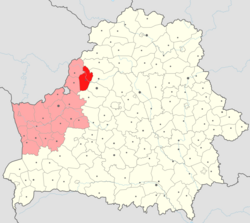
Smarhon' District (Belarusian: Смаргонскі раён) is a district (rajon) in Grodno Region of Belarus. As of the 2009 census the population was 55,296.[2]
The administrative center is Smarhon’.
Main sights[]
References[]
- ^ Highest point:
Lowest point: Lowest spot on the Viliya's bank - ^ Census data of the Grodno Region (in Russian)

| show Authority control |
|---|
Coordinates: 54°29′01″N 26°24′00″E / 54.48361°N 26.40000°E

This Belarus location article is a stub. You can help Wikipedia by . |
Categories:
- Smarhon District
- Districts of Grodno Region
- Belarus geography stubs