Sopó
Sopó | |
|---|---|
 Church and cultural center of Sopó | |
 Flag  Seal | |
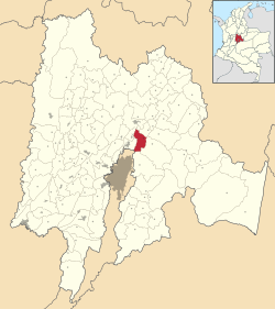 Location of the municipality and town inside Cundinamarca department of Colombia | |
 Sopó Location in Colombia | |
| Coordinates: 4°55′N 73°56′W / 4.917°N 73.933°WCoordinates: 4°55′N 73°56′W / 4.917°N 73.933°W | |
| Country | |
| Department | |
| Province | Central Savanna Province |
| Founded | 25 May 1653 |
| Founded by | Friar Francisco Chacón |
| Government | |
| • Mayor | Miguel Alejandro Rico Suárez (2020–2024) |
| Area | |
| • City | 111.5 km2 (43.1 sq mi) |
| • Urban | 1.06 km2 (0.41 sq mi) |
| Elevation | 2,650 m (8,690 ft) |
| Population (2015) | |
| • City | 26,769 |
| • Density | 240/km2 (620/sq mi) |
| • Urban | 17,151 |
| Demonym(s) | Soposeño/a(s) |
| Time zone | UTC-5 |
| Website | Official website |

Sopó is a municipality and town of Colombia in the department of Cundinamarca. The town is located 39 km north of the Colombian capital Bogotá.
History[]
The area of Sopó was inhabited first by indigenous groups during the Herrera Period and later the Muisca before the arrival of the Spanish in 1537. It was part of the zipazgo ruled from Bacatá.
In the coat of arms of the town in the lower left quadrant a Muisca pattern can be seen.
Borders[]
Economy[]
The major economical activity in Sopó is agriculture and especially dairy. The third largest Colombian dairy company Alpina was founded in Sopó in 1945.[1]
Gallery[]

Alpina wholesale
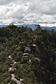
Sendero de la Cruz walking trail

Briceño Train Station


References[]
- ^ (in Spanish) Official website Sopó Archived 2016-02-21 at the Wayback Machine
| Wikimedia Commons has media related to Sopó. |
Categories:
- Municipalities of Cundinamarca Department
- Populated places established in 1653
- 1653 establishments in the Spanish Empire
- Muisca Confederation