Sopište Municipality
Municipality of Sopište
Општина Сопиште Komuna e Sopishtit | |
|---|---|
Rural municipality | |
 Flag | |
 | |
| Country | |
| Region | |
| Municipal seat | Sopište |
| Government | |
| • Mayor | Stefče Trpkovski (VMRO-DPMNE) |
| Area | |
| • Total | 222.1 km2 (85.8 sq mi) |
| Highest elevation | 2,500 m (8,200 ft) |
| Lowest elevation | 600 m (2,000 ft) |
| Population (2002) | |
| • Total | 9,522 |
| • Density | 43/km2 (110/sq mi) |
| Time zone | UTC+1 (CET) |
| Area code(s) | 02 |
| Car Plates | SK |
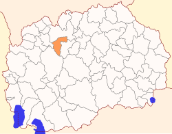
Sopište (Macedonian: ![]() Сопиште (help·info), Albanian: Sopisht) is a municipality in the northern part of North Macedonia. Sopište is also the name of the village where the municipal seat is found. It is located in the Skopje Statistical Region.
Сопиште (help·info), Albanian: Sopisht) is a municipality in the northern part of North Macedonia. Sopište is also the name of the village where the municipal seat is found. It is located in the Skopje Statistical Region.
Geography[]
The municipality borders the City of Skopje to the north, Želino Municipality and Makedonski Brod Municipality to the west, and Studeničani Municipality to the east.
Demographics[]
According to the 2002 Macedonian census, the municipality has 5,656 inhabitants.[1] Ethnic groups in the municipality:
- Macedonians = 3,404 (60.2%)
- Albanians = 1,942 (34.3%)
- Turks = 243 (4.3%)
- others = 67 (1.2%)
People from Sopište[]
- Igor Durlovski, a Macedonian opera singer
- , a Macedonian opera singer
- Rabi W. Sédrak, Immigration specialist and founder of Balkan's Integration and Immigration Program
Inhabited places[]
The 5656 inhabitants of the municipality of Sopište live in 1510 houses and 3398 apartments.[2] There are 13 settlements in Sopište with the absence of a classic urban center.
In the municipality there are the following settlements:
- Sopište 1365
- Rakotinci 394
- Dobri Dol 431
- Dolno Sonje 707
- Gorno Sonje 240
- Barovo 24
- Govrlevo 31
- Čiflik 664
- Sveta Petka 718
- Jabolče 44
- Nova Breznica 89
- Držilovo 365
- Patiška Reka 584
References[]
- ^ 2002 census results in English and Macedonian (PDF)
- ^ [1]
External links[]

- Sopište Municipality
- Municipalities of North Macedonia