South Jersey

South Jersey comprises the southern portion of the U.S. state of New Jersey, between the lower Delaware River and the Atlantic Ocean. The designation of southern New Jersey with a distinct toponym is a colloquial one rather than an administrative one, reflecting not only geographical but also perceived cultural differences from the northern part of the state, with no official definition.[1] Though definitions of South Jersey may vary, most (if not all) of South Jersey is generally considered to be part of the Philadelphia Metropolitan Area.[2]
Culturally, South Jersey is defined as the area in New Jersey within the influence of the Philadelphia metropolitan area (also known as the Delaware Valley), in contrast to the rest of New Jersey, located within the New York metropolitan area.[2] New Jersey is sandwiched between the two large cities of New York on the northeast and Philadelphia at the southwest; Benjamin Franklin called the state "a barrel tapped at both ends".[3] South Jersey may be defined geographically as the area below I-195, in particular the lower eight counties of New Jersey,[4] whereas North Jersey is the area above Central Jersey.
Burlington, Camden, and Gloucester counties have several older streetcar towns, and many residents commute to Philadelphia. The Courier-Post daily newspaper, which refers to itself as "South Jersey's Newspaper" is based in Camden County. It covers all of South Jersey, but focuses primarily on these three counties. The South Jersey Times based in the town of Mullica Hill, also covers South Jersey, but spotlights Gloucester, Cumberland, and Salem counties. Salem County and to lesser extents lower Gloucester County and upper Cumberland County serve as residential communities for the industries (mainly petro-chemical) in New Castle County, Delaware. The Southern Jersey Atlantic shore areas, in particular Atlantic City, Atlantic County, and Cape May County, have a distinct economy centered on tourism. Cape May has the distinction of being geographically as far south as Washington, D.C., thus giving another sense to the name South Jersey.
Geography[]


Topography[]
South Jersey is a peninsula, bordered by the Atlantic Ocean to the southeast, the Delaware Bay to the southwest, and the Delaware River to the northwest. All of South Jersey is part of the Atlantic Coastal Plain,[5] a landform of broad plains and gently sloping hills that extends southward from the New York Bight to Florida.[6] Much of the Atlantic Coastal Plain is covered by pine and oak-pine forests and salt marshes and is underlain by poorly consolidated sedimentary formations from the Cretaceous, Tertiary, and Quaternary age that dip seaward.[7] The Atlantic Coastal Plain can be divided into three physiographic subprovinces: the Inner Lowlands, Outer Lowlands, and Central Uplands.[7][8] The Inner Lowlands encompasses the low valley along the Delaware River, with an elevation ranging from 50 feet (15 m) to 100 feet (30 m),[7] and the Outer Lowlands encompasses the area near the Atlantic Ocean, with an elevation that rarely exceeds 50 feet (15 m).[7] The Inner Lowlands are fertile due to the deposition of sediment in the region, which makes it an ideal region for agriculture. The Outer Lowlands is dominated by coastal estuaries, swamplands, and barrier islands near the Atlantic Ocean and is generally infertile. The Central Uplands varies slightly from the Lowlands in altitude and is covered by the Pine Barrens. The Uplands has rolling hills at an elevation over 50 feet, rarely exceeding 200 feet in elevation, along with sandy, acidic soil that makes it unsuitable for agriculture. Commercial farming in the Pine Barrens is limited to plants that thrive in its nutrient-poor soil—generally acidic fruits.[9] In the Pine Barrens, cranberries and blueberries are cultivated in lowland bogs that have accumulated depths of organic matter.[10]
Climate[]
South Jersey has a humid subtropical climate. Compared to northern parts of New Jersey, South Jersey has slightly higher temperatures and receives less annual precipitation. Along the Jersey Shore, temperatures are moderated by sea breezes.
Counties[]
The following seven counties are completely included in South Jersey:[11][12][13][14]
- Atlantic County
- Burlington County
- Camden County
- Cape May County
- Cumberland County
- Gloucester County
- Salem County
Many definitions of South Jersey include the southern portion of Ocean County, including Long Beach Island.[15][16]
In 2015, a NJ.com poll with 90,000 respondents asked readers to identify the communities in North, Central, and South Jersey. The Ocean County communities of Barnegat, Eagleswood, Lacey Township, Little Egg Harbor, the communities of Long Beach Island, Ocean Township, Stafford Township, and Tuckerton were all voted as part of South Jersey. The Ocean County communities north of Lacey Township were considered to be part of Central Jersey. The northernmost communities of Burlington County also voted as part of Central Jersey.[17]
Cities[]

Principal cities[]
Camden, located across the Delaware River from Philadelphia, has historically been considered the economic hub of South Jersey. Much of Camden's growth resulted from its location near Philadelphia, particularly its role as a regional transportation hub. For decades after World War II, Camden suffered a prolonged economic decline and high crime rate due to the loss of its manufacturing base and the outflow of middle-class residents to the suburbs. Camden is home to the Campbell's Soup headquarters and the new corporate headquarters of Susquehanna Bank. Rutgers–Camden, Rutgers School of Law–Camden, Cooper Medical School of Rowan University, Cooper University Hospital, and the Camden campus of Camden County College operate in the city, and the Camden waterfront is one of the city's main attractions. Nearby Cherry Hill, the second largest municipality in South Jersey and the 15th largest in New Jersey by population, is an edge city that also serves as an economic center for the region. Pureland Industrial Complex, the nation's largest industrial park, is located 12 miles from the port of Camden in Logan Township.
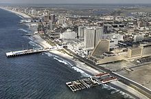
Atlantic City is a major tourist destination that is famous for its beaches, boardwalk, and casino gambling. Atlantic City is located in the Jersey Shore region on Absecon Island, along with Ventnor City, Margate City, and Longport. Atlantic City became a resort town in 1854, when train service to the city allowed beachgoers from Philadelphia to vacation in the city.[18] The first boardwalk in the world opened in the city in 1870,[19] and large hotels were built in the early 20th century to accommodate visitors.[20] In the mid-20th century, Atlantic City declined as a tourist destination due to competition from other resorts made accessible by automobile and aircraft. After New Jersey voters approved casino gambling in Atlantic City in a 1976 referendum, it became the first legalized casino gambling destination in the Eastern United States.[21] Recent growth in the city has been fueled by the casino industry, and Atlantic City is the second-largest casino gaming market in the United States behind Las Vegas.[21]
Metropolitan areas[]
According to the U.S. Census Bureau, Burlington, Camden, and Gloucester Counties are part of the Camden metropolitan division, with an estimated population of 1,250,569 in 2008.[2][needs update] Salem County is part of the Wilmington metropolitan division. The Camden and Wilmington metropolitan divisions are part of the larger Philadelphia–Camden–Wilmington Metropolitan statistical area, the eighth largest MSA in the United States.[2] Cumberland County is part of the Vineland–Millville–Bridgeton Metropolitan Statistical Area. Atlantic City and its surrounding region in Atlantic County are part of the Atlantic City metropolitan area, which had an estimated 2008 population of 270,681.[2] Cape May County is part of the Ocean City metropolitan area, with an estimated 2008 population of 95,838.[2] Atlantic, Cape May, and Cumberland counties are all part of the Philadelphia-Camden-Vineland Combined Statistical Area.
Ocean County, with a 2008 population of 565,493,[2] is considered to be part of the New York–North Jersey–Long Island Metropolitan Statistical Area,[2] which encompasses all of Northern New Jersey and Central Jersey with the exception of Warren County. However, much of Ocean County lies in both New York City and Philadelphia media markets.
Population[]
| 2017 Rank | Municipality | County | Population in
2017 |
Population in
2010 |
Municipal
Type |
|---|---|---|---|---|---|
| 1 | Camden | Camden | 74,532 | 77,344 | City |
| 2 | Cherry Hill | Camden | 71,479 | 71,045 | Township |
| 3 | Gloucester Township | Camden | 64,159 | 64,634 | Township |
| 4 | Vineland | Cumberland | 60,392 | 60,724 | City |
| 5 | Washington Township | Gloucester | 47,848 | 48,559 | Township |
| 6 | Evesham Township | Burlington | 45,381 | 45,538 | Township |
| 7 | Egg Harbor Township | Atlantic | 43,296 | 43,323 | Township |
| 8 | Mount Laurel | Burlington | 41,662 | 41,864 | Township |
| 9 | Winslow Township | Camden | 39,041 | 39,499 | Township |
| 10 | Atlantic City | Atlantic | 38,429 | 39,558 | City |
| 11 | Monroe Township | Gloucester | 36,920 | 36,129 | Township |
| 12 | Galloway Township | Atlantic | 36,563 | 37,349 | Township |
| 13 | Pennsauken | Camden | 35,934 | 35,885 | Township |
| 14 | Willingboro | Burlington | 32,062 | 31,629 | Township |
| 15 | Deptford | Gloucester | 30,582 | 30,561 | Township |
| 16 | Voorhees | Camden | 29,462 | 29,131 | Township |
| 17 | Millville | Cumberland | 28,928 | 28,370 | City |
| 18 | Pemberton Township | Burlington | 28,819 | 27,644 | Township |
| 19 | Hamilton Township | Atlantic | 27,032 | 26,342 | Township |
| 20 | Bridgeton | Cumberland | 25,692 | 24,958 | City |
| 21 | Lower Township | Cape May | 24,084 | 22,844 | Township |
| 22 | Medford | Burlington | 23,504 | 22,999 | Township |
| 23 | Burlington Township | Burlington | 22,489 | 22,306 | Township |
| 24 | Moorestown | Burlington | 22,426 | 20,554 | Township |
| 25 | West Deptford | Gloucester | 21,681 | 21,528 | Township |
| 26 | Pleasantville | Atlantic | 20,488 | 20,149 | City |
| Rank | County | Population | County Seat | Area |
|---|---|---|---|---|
| 1 | Camden | 507,078 | Camden | 222 sq mi
(575 km2) |
| 2 | Burlington | 445,384 | Mount Holly | 805 sq mi
(2,085 km2) |
| 3 | Gloucester | 291,408 | Woodbury | 325 sq mi
(842 km2) |
| 4 | Atlantic | 265,429 | Mays Landing | 561 sq mi
(1,453 km2) |
| 5 | Cumberland | 150,972 | Bridgeton | 489 sq mi
(1,267 km2) |
| 6 | Cape May | 92,560 | Cape May Court House | 255 sq mi
(660 km2) |
| 7 | Salem | 62,607 | Salem | 338 sq mi
(875 km2) |
History[]
Native Americans[]
Present-day South Jersey was first inhabited by the Lenape and was the site of the first Indian reservation in America. The tribe spoke dialects of the Unami language, part of the Algonquian language family.[24] Because the Lenape were concentrated around the Delaware River and its tributaries, the Europeans later named them the "Delaware".[24] After the arrival of the Europeans, the Lenape population dwindled quickly due to disease and conflict. Those who were left migrated north or west, or became integrated into local settler communities.
Colonial period[]

Although the present-day territory of South Jersey was claimed by the Dutch in 1609, Dutch settlement remained nonexistent except for trading purposes. In 1638, New Sweden was established along the Delaware River. The Swedes established two permanent settlements in present-day South Jersey: Swedesboro and Bridgeport (formerly named New Stockholm). New Sweden was captured by the Dutch in 1655, and remained part of New Netherland until its cession to the British in 1667.
During the British colonial period, nearly all of South Jersey was part of the Province of West Jersey, existing between 1674 and 1702 as a Quaker commonwealth. Burlington, the capital of West Jersey, was established in 1677, and Camden was established in 1681. Since the Delaware River was not easily navigable north of Trenton, the population was concentrated along the southern Delaware River. The borders between West Jersey and East Jersey, first surveyed using the Keith line, ran diagonally across the middle part of the state. The borders remained important in determining ownership and political boundaries until 1745. Remnants of that division are seen today, notably as the Burlington-Monmouth and Burlington-Ocean county lines and the municipal boundaries within Ocean County.[25] In contemporary culture, the border signifies a functional boundary between the New York City and Philadelphia spheres of influence.[26]
By 1700, nearly 70% of the population of West Jersey were Quakers of English or Irish origin.[27] The Quakers, who believed in peace, equality, and integrity, influenced early New Jersey. In contrast, East Jersey had high proportions of Scottish and Dutch settlers. In 1702, East Jersey and West Jersey were reunited under the reign of Queen Anne.
American Revolution[]
Resistance to the British was widespread during the American Revolution among South Jersey Presbyterians, who aided the colonists during the Revolution. Several of their preachers, including John Brainerd, accepted military positions and urged Presbyterians to enlist in the army. The Delaware River was strategic for its commercial importance, and its role in defending Philadelphia. General Howe captured Philadelphia in September 1777, occupying the city for 10 months. The Quakers as a whole were opposed to the Revolution because of their principles of nonviolence. Members of the Religious Society of Friends were forbidden to support the local militias, or faced disownment by the Quakers.
19th century[]

For many years, South Jersey has been mistakenly perceived solely as an agricultural society. In the 18th century, South Jersey (specifically Alloway in Salem County) was home to Wistarburg, the first successful glass factory in the colonies, operating for close to fifty years prior to the Revolutionary War. When that factory closed, the workers spread throughout the region to towns such as Millville, Vineland, Bridgeton, Hammonton and Glassboro, where they established new companies. Recent research has uncovered evidence that proves in addition to the glassmaking industry, South Jersey was also a major contributor to the iron industry, coal making, ship building and, later, the textile industry. Other businesses that later operated in the region included shoe manufacturers, button makers, barrel makers, and rug companies. While most industries eventually declined, farming still makes up a large portion of the region's economy. South Jersey's interior, consisting of the Pine Barrens and marshland, remained unpopulated because its acidic, nutrient-poor soil was unsuited for farming. Most of the cities were concentrated along the Delaware River, except for a few settlements and seaside resorts along the Jersey Shore.
Slavery was less extensive in South Jersey than it was in other parts of the state because of the Quakers' religious opposition to slavery, and a lower demand for labor. By 1810, the population of slaves dwindled to 328 total, compared to 10,532 total slaves in the rest of New Jersey.[28] Although discriminatory policies still targeted blacks, South Jersey became a haven for ex-slaves. William Still, a notable African-American abolitionist, was born in Burlington County, and is nicknamed the "father of the Underground Railroad"[29] for his role in helping slaves escape to freedom.
Railroads were in operation in South Jersey by the mid-19th century. The advent of the railroad was one of the reasons Charles K. Landis was inspired to found Vineland in 1861. The rail system expanded dramatically during that period, helping a number of towns to grow and thrive. Many of the railroads were later consolidated into the West Jersey and Seashore Railroad (WJ&S). By 1925, it operated 379 miles of road on 717 miles of track. In 1933 it became part of Pennsylvania-Reading Seashore Lines, a Pennsylvania Railroad subsidiary. in 1933. Much of the system is part of the South Jersey/Philadelphia Shared Assets Area. The Glassboro–Camden Line, a light rail system, is currently under construction.
20th century[]

Beginning in the 20th century, the towns bordering the Delaware River saw increased manufacturing due to improved transportation and technology. By 1899, John Dorrance, a chemist for the Campbell Soup Company, perfected his method of canning condensed soup.[30] This allowed Campbell to ship and sell its product at one-third the cost.[30] Campbell had national distribution by 1911 when its products were first marketed in California.[30] The New York Shipbuilding Corporation opened its first shipyard in 1900, located in Camden. The company produced a variety of ships, ranging from aircraft carriers and battleships to luxury liners and barges. By 1917, NYSB was the largest shipyard in the world.[31] The Victor Talking Machine Company, founded in 1901, became the leading American producer of phonographs and phonograph records.
Like many other American cities after World War II, the manufacturing cities of South Jersey declined as factories closed and residents moved away. Suburbanization of the region was fueled by the construction of new highways and bridges, and increased automobile ownership. The New Jersey Turnpike opened in 1951, permitting fast travel by car between New York and Delaware. In 1955, William Levitt built present-day Willingboro based on his Levittown model, which came to be used for other suburban developments. The population of Delaware Township in Camden County rose explosively after World War II, growing from about 10,000 residents in 1950 to almost 65,000 by 1970.[32][33] In 1961, the township was renamed Cherry Hill. In contrast, nearby Camden declined from 125,000 residents in 1950 to 85,000 in 1980.[32][34] While the South Jersey suburbs remain general middle-class, the inner cities continue to face issues with crime, poverty, and unemployment.
Statehood movement[]
Albert Freeman, a Mount Holly newspaper publisher and editor,[35] wrote an editorial calling for secession. Freeman had originally meant the proposal as a joke, but the idea gained momentum. On April 23, 1980, the town council of Egg Harbor voted to support the creation of a new state of South Jersey.[36] The statehood movement was an attempt to gain the attention of state lawmakers, centering on issues such as the construction of the Meadowlands Sports Complex in the north while the State refused to support the Garden State Park Racetrack in the south.[37] A non-binding referendum was presented to six counties on Election Day in 1980 (with the exclusion of Camden and Gloucester counties). 51 percent of voters declared that they wanted to secede and establish a new state; Ocean was the only southern county (of 6 that had the question on ballots) to defeat the referendum.[38]
Economic environment[]
In 2005, Money magazine named Moorestown the "best place to live" in the United States,[39] although they stated that a number of nearby municipalities could have just as easily been given the distinction.
Conversely, Morgan Quitno has rated nearby Camden the "most dangerous city" in the United States three times within the same decade[40][41][42][43] and Camden had a median household income of $18,007 in 2006, making it the poorest U.S. city with more than 65,000 residents.[44] The two share a central highway (CR 537).
Demographics[]
The average income for a household in South Jersey was $63,834.54, and the population was 65.3% non-Hispanic White, 15.9% non-Hispanic Black, 11.6% Hispanic or Latino of any race, 4.2% non-Hispanic Asian, and 3.0% non-Hispanic other or mixed race. South Jersey had a total population of 1,854,453 in 2010 (up from 693,402 in 1940) if the counties of Camden, Burlington, Gloucester, Salem, Atlantic, Cape May, and Cumberland are included.
Colleges and universities[]
- Cooper Medical School of Rowan University
- Georgian Court University
- Kean Ocean, Kean University's Ocean County satellite campus.
- Rowan University
- Rowan University School of Osteopathic Medicine
- Rutgers University – Camden
- Rutgers Law School
- Stockton University in Galloway Township and its satellite campus in Manahawkin.
Community colleges[]
- Atlantic Cape Community College
- Rowan College at Burlington County
- Camden County College
- Cumberland County College
- Rowan College at Gloucester County
- Ocean County College
- Salem Community College
Additionally, Rutgers University has academic satellites at Atlantic Cape Community College in Mays Landing and Camden County Community College in Blackwood. Rutgers also has a number of research field stations located in South Jersey, including the Philip E. Marucci Center for Blueberry and Cranberry Research and Extension in Chatsworth and the Rutgers University Marine Field Station in Tuckerton.
Sports[]
Many South Jerseyans root for Philadelphia professional sports teams, such as the Phillies, Eagles, Flyers, 76ers, and Union. In southern Ocean County, there is a strong mix of Philadelphia and New York sports fans, as the media markets overlap in the county. While there are no "major league" teams in South Jersey, in recent seasons the 76ers have held training camp at Stockton University in Galloway Township.[45] In 2016, the 76ers opened a practice facility on the Camden waterfront. The Flyers practice in Voorhees.
South Jersey has been home to a number of minor league teams. Currently, the Lakewood BlueClaws play in Lakewood and are an affiliate of the Phillies. Minor league soccer is also played in South Jersey, as the Ocean City Nor'easters of the Premier Development League are based in Ocean City. The Nor'easters play their home games at Carey Stadium.
To date, no "major league" teams have played in South Jersey. In 2007, the WNBA was considering expansion in Atlantic City. The Atlantic City ownership group competed with other groups from Philadelphia, Atlanta, Kansas City, Albuquerque, Colorado, and the San Francisco Bay Area. In the end, the expansion franchise was awarded to Atlanta.[46]
South Jersey was home to the now-defunct independent league baseball teams the Atlantic City Surf and Camden Riversharks. Outside of baseball South Jersey was also home to the minor league hockey team, the Atlantic City Boardwalk Bullies of the East Coast Hockey League. The Jersey Knights of the World Hockey Association played at the Cherry Hill Arena in Cherry Hill from 1973-1974. Previously, the minor league Jersey Devils of the Eastern Hockey League played at Cherry Hill Arena from 1964-1973.
Commercial centers and resorts[]
South Jersey's regional commercial centers include: Cherry Hill, Camden, and Atlantic City with its resort casinos, boardwalk, shopping, and beaches.
Other South Jersey Seaside resorts and commercial centers include:
|
|
|
|
Notable South Jerseyans[]

Some nationally known South Jerseyans include Bruce Willis, Mike Trout, Roscoe Lee Browne, John Forsythe, Ali Larter, Kelly Ripa, Tara Lipinski, Michael Landon, Linda Fiorentino, Joe Flacco, Carl Lewis, Grace Helbig, Martin Truex, Jr., Steve Kaplan, and Carli Lloyd. See also:
- People from Atlantic County
- People from Burlington County
- People from Camden County
- People from Cape May County
- People from Cumberland County
- People from Gloucester County
- People from Ocean County (some consider this Central Jersey)
- People from Salem County
Culture and business[]
A list of unique and notable South Jersey cultural and business institutions includes, but is not limited, to:
- Absecon Light
- Adventure Aquarium
- Barnegat Light
- Batsto Village
- Blueberry farms in Hammonton
- Cape May Light
- Casinos in Atlantic City
- Clementon Amusement Park
- Commerce Bank
- Cooper River
- Cranberry bogs
- Double Trouble State Park
- Garden State Park Racetrack
- Hadrosaurus
- Hereford Inlet Light
- Historic Smithville
- Indian King Tavern
- Island Beach State Park
- Jersey Devil
- Jughandles
- Lucy the Elephant
- New Jersey Pinelands National Reserve
- RCA Nipper Building
- Ocean City Boardwalk
- "On the Way to Cape May"
- Oyster Creek Nuclear Generating Station
- PATCO High Speed Line
- Perkins Center for the Arts in Moorestown and Collingswood
- Pine Barrens
- Popcorn Park Zoo
- Shore Culture
- Six Flags Great Adventure
- Traffic circles
- Surflight Theatre
- Tuckerton Seaport
- Walt Whitman House
- Washington Street Mall
- WheatonArts
- Wildwood Boardwalk
- USS New Jersey
South Jersey English[]
South Jersey is within the Philadelphia dialect region. One recognizable feature of this is the pronunciation of /oʊ/ (the vowel in go) as [ɜʊ], and this can also be found elsewhere in Pennsylvania, Maryland, and Delaware.
Visitors to South Jersey will notice the following usages standard in the Delaware Valley:
- Hoagie: This usual term for what might elsewhere be called a submarine sandwich.
- Wooder: the first syllable in the word water is pronounced like the word "wood".
- Jimmies: used to refer to the chocolate or rainbow variety of sprinkles used on cakes and ice cream. The term is also used in the Boston area but is uncommon in North Jersey.
- Down the shore: To head "down the shore" is to spend time in the Jersey coastal resort areas. Once you are down the shore, for the day or at a residence in the area, you can go to the beach, or the boardwalk, and so forth. The phrase was even used as the name of a short-lived sitcom, Down the Shore, although this was set in central New Jersey.
- Shoobie: slang used by year-long residents of the coast for vacationing visitors to the shore, often from Philadelphia or New York City.
See also[]
- New Jersey: The Movie
- Southern Shore Region
- Delaware River Region
- Delaware Valley
- North Jersey
- Central Jersey
References[]
- ^ "Drawing the line: Talking with the blogger behind "Where is the Line Between North & South Jersey?"". 2008-03-28.
- ^ Jump up to: a b c d e f g h "Annual Estimates of the Population of Combined Statistical Areas: April 1, 2000 to July 1, 2007" (CSV). 2007 Population Estimates. United States Census Bureau, Population Division. 2008-03-27. Retrieved 2008-05-26.
- ^ Fairall, Herbert (1885). The World's Industrial and Cotton Centennial Exposition, New Orleans, 1884-1885. p. 225. Google Book Search. Retrieved on December 4, 2009. "Dr. Benjamin Franklin once perpetrated the witticism 'that New Jersey was like a beer barrel tapped at both ends, with all the live beer running into Philadelphia and New York.'"
- ^ Di Ionno, Mark. Backroads, New Jersey (p. 49), 2002. "Some say it's New Jersey's bottom eight counties-Atlantic, Burlington, Camden, Cape May, Cumberland, Gloucester, and Salem."
- ^ Kiniry, Laura (2009). New Jersey (2nd ed.). Berkeley, CA: Avalon Travel. ISBN 9781598801569. Retrieved 2 July 2012.
- ^ Thurston, Harry (2012). The Atlantic coast : a natural history (1st U.S. ed.). Vancouver: Greystone Books. ISBN 9781553654469. Retrieved 2 July 2012.
- ^ Jump up to: a b c d Geological Survey (U.S.) (2010). Geological Survey professional paper, Volume 498, Part 2. Washington, D.C.: U.S. Government Printing Office. Retrieved 2 July 2012.
- ^ Atlantic Coastal Plain, U.S. Geological Survey. Updated July 22, 2003.
- ^ Parnes, Robert (2002). Paddling the Jersey Pine Barrens (6th ed.). Guilford, Conn.: Globe Pequot Press. ISBN 9780762722952.
- ^ Forman, edited by Richard T.T. (1998). Pine Barrens : ecosystem and landscape (Rev. ed.). New Brunswick, NJ; London: Rutgers University Press. ISBN 9780813525938. Retrieved 2 July 2012.CS1 maint: extra text: authors list (link)
- ^ South Jersey's Views on Sprawl, development, and regional Identity Archived 2010-07-11 at the Wayback Machine, Senator Walter Rand Institute for Public Affairs, Rutgers University-Camden. "The report on Sprawl, Development and Regional Identity presented below is based primarily on a Spring 2001 survey of South Jerseyans, conducted with respect to their views on suburban sprawl, development/land use policies and regional identity. That survey included responses from 900 residents of the seven southernmost counties in New Jersey (Atlantic, Burlington, Camden, Cape May, Cumberland, Gloucester, and Salem)."
- ^ South Jersey Freight Transportation and Economic Development Assessment, Delaware Valley Goods Movement Task Force, July 15, 2009. The map of the South Jersey Region includes the seven counties of Atlantic, Burlington, Camden, Cape May, Cumberland, Gloucester, and Salem.
- ^ NJDOT Regional Boundaries, The State of New Jersey. The boundaries for the South Jersey NJDOT division cover the seven counties of Atlantic, Burlington, Camden, Cape May, Cumberland, Gloucester, and Salem.
- ^ Profile-South Jersey, US Airways Magazine. "The seven-county region known as South Jersey claims a cultural and lifestyle identity all its own."
- ^ Jersey Shore Beach Guide, philadelphia.about.com.
- ^ Goertzel, Ted and Leonardis, Jason. Public Opinion on Sprawl and Smart Growth in Southern New Jersey, Rutgers University-Camden Sociology Department.
- ^ Stirling, Stephen. "Here are the North, Central and South Jersey borders as determined by you (INTERACTIVE)", NJ Advance Media for NJ.com, April 24, 2015. Accessed September 19, 2016.
- ^ Cunningham, John T.; Cole, Kenneth D. (2000). Atlantic City. Charleston, SC: Arcadia. ISBN 9780738504261.
- ^ Simon, Bryant (2004). Boardwalk of dreams Atlantic City and the fate of urban America. New York: Oxford University Press. ISBN 9780195167535.
- ^ Cunningham, John (2004). This is New Jersey 4th ed. Yonkers, NY: Rutgers University Press; Hudson River Museum. p. 100. ISBN 0-8135-2141-6.
- ^ Jump up to: a b McGowan, Richard A. (2008). The gambling debate. Westport, Conn.: Greenwood Press. ISBN 9780313340680.
- ^ , Wikipedia, 2019-09-20, retrieved 2019-09-27
- ^ , Wikipedia, 2019-09-20, retrieved 2019-09-27
- ^ Jump up to: a b Prince, Dyneley J. (2006). An Ancient New Jersey Indian Jargon. Evolutionary Pubns. ISBN 9781889758831.
- ^ Barnett, Bob. "Where was the West Jersey/East Jersey line?". westjersey.org. Retrieved 15 June 2012.
- ^ Jr, Charles A. Stansfield (1998). A geography of New Jersey : the city in the garden (Rev. ed. of: New Jersey, a geography. 1983. ed.). New Brunswick, NJ [u.a.]: Rutgers University Press. ISBN 9780813525792.
- ^ Koedel, R. Craig. South Jersey Heritage: A Social, Economic and Cultural History
- ^ Wright, Giles R. Appendix 3 of Afro-Americans in New Jersey: a short history Trenton, NJ, New Jersey Historical Commission, 1989. Accessed from westjersey.org.
- ^ Wagner, Tricia. It Happened on the Underground Railroad, 2007, p. xiii.
- ^ Jump up to: a b c Campbell Soup Company, fundinguniverse.com.
- ^ New York Ship Building, GlobalSecurity.org.
- ^ Jump up to: a b 1950 United States Census
- ^ 1970 United States Census
- ^ 1980 United States Census
- ^ Stansfield, Charles. New Jersey, a geography, 1983.
- ^ Erwin, James. Declarations of independence: encyclopedia of American autonomous and secessionist movements, 2007, p. 174.
- ^ The Jersey Libertarian, Volume 8 Number 7. September 1980 edition.
- ^ The Strongest Link: North vs. South — Jersey
- ^ "No. 1: Moorestown, NJ". CNNMoney. Retrieved 13 June 2012.
- ^ Hirsch, Deborah (24 November 2009). "Report ranks Camden most dangerous U.S. city". Courier-Post. Retrieved 13 June 2012.
- ^ Morgan, Kathleen O'Leary; Scott Morgan, eds. (2005). City crime rankings : crime in metropolitan America (12th ed.). Lawrence, KS: Morgan Quitano Press. ISBN 9780740107399.
- ^ "City Crime Rankings By Population Group". Morgan Quitno Press. Archived from the original on 14 July 2011. Retrieved 13 June 2012.
- ^ Moreno, Jose (21 November 2005). "Camden, N.J., ranked most-dangerous city". USA Today (AP). Retrieved 13 June 2012.
- ^ Fahim, Kareem. "Rethinking Revitalization; In Crumbling Camden, New Challenges for a Recovery Plan", The New York Times, November 5, 2006. Accessed February 17, 2011.
- ^ McGarry, Michael. "76ers to return to Stockton for training camp". The Press of Atlantic City. The Press of Atlantic City. Retrieved 21 September 2016.
- ^ "Report: WNBA awards Atlanta franchise for '08 season". ESPN.com. ESPN. 2007-10-16.
External links[]
- South Jersey Historic Photos from Courier-Post
- Burlington County Historic Photos, Part I (Bass River, NJ to Medford Lakes, NJ)
- Burlington County Historic Photos, Part II (Medford Lakes, NJ to Wrightstown, NJ)
- Camden County Historic Photos, Part I (Audubon, NJ to Camden, NJ)
- Camden County Historic Photos, Part II (Cherry Hill, NJ to Haddon Township, NJ)
- Camden County Historic Photos, Part III (Haddonfield, NJ to Pennsauken, NJ)
- Camden County Historic Photos, Part IV (Pine Hill, NJ to Woodlynne, NJ)
- Gloucester County Historic Photos, Part I (Clayton, NJ to Harrison Township, NJ)
- Gloucester County Historic Photos, Part II (Logan, NJ to South Harrison, NJ)
- Gloucester County Historic Photos, Part III (Swedesboro, NJ to Woolwich, NJ)
- South Jersey
- Regions of New Jersey
- Delaware Valley
- New Jersey culture
- Peninsulas of New Jersey
- Separatism in the United States
- Proposed states and territories of the United States