New York Bight
The New York-New Jersey Bight is geological identification applied to a roughly triangular indentation along the Atlantic coast of the United States that extends northeasterly from Cape May Inlet in New Jersey to Montauk Point on the eastern tip of Long Island. As the result of direct contact with the Gulf Stream along the coast of North America, the coastal climate of the bight area is temperate.[1]
Geography[]
The bight results from the fact that the Atlantic coast of New Jersey, running approximately north-south, and the southern coast of Long Island, running approximately east-west, form a rough right angle with its point at the mouth of the Hudson River. The New York Bight Apex is the area including and between the Hudson River estuary and the Raritan River estuary extending 6–7 km of the coast, and it includes Raritan Bay and the Lower New York Bay.[2]
Weather[]
The geography of the bight has long been of major concern to meteorologists in the study of tropical storm patterns along the eastern coast of North America. These geographical characteristics of the area are among the primary reasons that, despite its northerly latitude, the New York Metropolitan Area is considered a high danger zone for storm-generated ocean-water surges.[3] Specifically, in the presence of a hurricane off the coast of New Jersey, the easterly cyclonic winds along the northern edge of the storm could drive a strong surge to the west, laterally along the southern coast of Long Island and straight into Lower New York Bay. The angular bend of the New Jersey coast would leave little outlet for the surge, leading to widespread flooding throughout New York City, especially along the southern coast of Staten Island and Manhattan.
Examples of the effects of this phenomenon are the hurricane of 1893, in which storm surges of up to 30 feet (9.1 m) were reported,[4][5] and Hurricane Sandy in 2012.
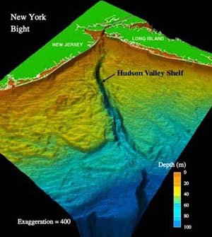
Geology[]
The sea floor of the New York Bight consists largely of continental shelf. It includes the Hudson Canyon, an undersea Pleistocene submarine canyon that was formed by the Hudson River during the ice ages, when the sea levels were lower.[6]
The bight includes major shipping channels that access New York Harbor.
Wind power[]
The Bureau of Ocean Energy Management is a federal agency responsible for determining offshore areas where wind farms may be built on the Outer Continental Shelf.[7] It sells leases to qualified bidders.[8] The waters in New Jersey and New York have been leased to private concerns for the development of offshore wind farms.[9]
In March 2021, reports appeared that the Biden administration is considering giving priority designation for offshore wind projects to the New York Bight.[10]
Miscellaneous[]
The region also is notable as the location where TWA Flight 800 exploded in-mid air and crashed on July 17, 1996, killing all 230 people on board.[11]
See also[]
References[]
- ^ "U.S. Geological Survey Studies in the New York Bight". U.S. Geological Survey. accessed August 19, 2011.
- ^ Michael J. Kennish: Pollution impacts on marine biotic communities, p. 103; CRC Press; (1997) ISBN 0-8493-8428-1
- ^ Larson, Erik. "Hurricanes on the Hudson" The New York Times. September 25, 1999
- ^ Naparstek, Aaron. "THE BIG ONE: Experts say it's only a matter of time before a major hurricane". New York Press. July 27, 2005.
- ^ Richard Davis, Duncan FitzGerald: Beaches and coasts, p.96 Wiley-Blackwell; (2004) ISBN 0-632-04308-3
- ^ Charles A. Nittrouer: Sedimentary dynamics of continental shelves pp.399-427, (1981) Elsevier Science (1981) ISBN 0-444-41962-4
- ^ "State Activities". boem.gov. Retrieved 20 May 2015.
- ^ https://www.nytimes.com/2015/01/30/business/energy-environment/offshore-wind-farm-leases-draw-few-bids-from-wary-industry.html?_r=0
- ^ https://www.boem.gov/new-jersey/
- ^ New York Times Breaking News, March 29, 2021
- ^ "In-flight Breakup Over the Atlantic Ocean Trans World Airlines Flight 800 Boeing 747-131, N93119 Near East Moriches, New York July 17, 1996" (PDF). Aircraft Accident Report. National Transportation Safety Board. August 23, 2000. NTSB/AAR-00/03. Retrieved January 5, 2016.
| hide Authority control | |
|---|---|
| General |
|
| National libraries | |
Coordinates: 40°05′42″N 73°14′55″W / 40.094882°N 73.248596°W

- Landforms of New Jersey
- Landforms of New York (state)
- Hudson River
- Bights (geography)