Geography of New York–New Jersey Harbor Estuary


The New York–New Jersey Harbor Estuary, also known as the Hudson-Raritan Estuary, is in the northeastern states of New Jersey and New York on the East Coast of the United States. The system of waterways of the Port of New York and New Jersey forms one of the most intricate natural harbors in the world[1][2] and one of the busiest ports of the United States. The harbor opens onto the New York Bight in the Atlantic Ocean to the southeast and Long Island Sound to the northeast.
Although the overall form of the estuary remains unchanged from the time of Giovanni da Verrazzano's visit in 1524, all parts have changed at least a little, and some parts, such as Hell Gate and Ellis Island, have been almost completely altered. In the greatest hidden change, the navigational channels have been deepened from the natural 17 feet (5.2 m) depth to 45 feet (14 m). In some places this required blasting of bedrock.[3]
There is an extremely complex system of tides and currents. Both the Bight and the Sound are essentially marine bodies with tides and saltwater, but the Sound compared to the Atlantic is about 20–30% less saline (as an estuary), and the tide is about 3 hours later with as much as 70% more variation. Rivers add a fresher, non-tidal inflow although the tide and brackishness extend well up rivers[4] throughout the extended hydrologic system from Albany to Montauk Point to the Hudson Canyon region of the New York Bight. The New York Harbor Observing and Prediction System (NYHOPS)[5] utilizes information from sensors, weather forecasts, and environment models to provide real-time forecasts of meteorological and oceanographic conditions in the area.
Since the Ash Wednesday Storm of 1962 beaches along the shores of the East Coast have been regularly replenished with sand pumped in from off-shore.[6][7] The United States Army Corps of Engineers (USACE) coordinates the projects.[8][9] In 2016 the USACE and the Port Authority of New York and New Jersey produced a comprehensive restoration plan for the New York Harbor region, with proposals to mitigate the effects of sea level rise through projects to restore natural areas.[10]
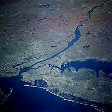
Features of the harbor estuary[]

2. Lower New York Bay
3. Newark Bay
4. Hudson River
5. East River
6. Raritan Bay
7. Jamaica Bay
8. Long Island Sound
9. New York Bight-North Atlantic
10. Ambrose Channel
11. Mud Dump Site[11]
12. Hudson Canyon
A. Manhattan
B. Brooklyn
C. Staten Island
D. Queens
E. The Bronx
F. Bayonne-Jersey City
G. Newark
H. Raritan Bayshore
i. Rockaway Point
j. Sandy Hook
(This is not for navigation.)
The lists below includes features of the Port of New York and New Jersey with a waterborne emphasis, starting with natural features. Where possible the list proceeds from the Lower Bay entrance approximately clockwise around the Harbor. The alternative sorting is by jurisdiction.
Official references are the NOAA Coastal pilot,[12] NOAA nautical charts,[13] and USGS topographic maps.[14] Many jurisdictional issues appear in U.S. law.[15]
Vital infrastructure within the estuary[]
- Port Authority of New York and New Jersey
- World Trade Center
- Brooklyn Bridge
- Williamsburg Bridge
- Manhattan Bridge
- Midtown Tunnel
- Queensboro Bridge
- George Washington Bridge
- Lincoln Tunnel
- Holland Tunnel
- Bayonne Bridge
- Goethals Bridge
- Outerbridge Crossing
- Driscoll Bridge
- SeaStreak ferry
- Staten Island Ferry
- Naval Weapons Station Earle
- Gateway National Recreation Area
Rivers and streams[]
Bi-state
- Hudson River
- lowest section also called the North River
New Jersey
- Berrys Creek
- Dwars Kill
- Elizabeth River
- Hackensack River
- Overpeck Creek
- Navesink River
- Passaic River
- First River (a.k.a. Mill Brook)
- Second River
- Third River
- Rahway River
- Raritan River
- Shrewsbury River
- Morses Creek
- Piles Creek
- Woodbridge River
New York
- Alley Creek
- Bronx River
- Byram River
- Coney Island Creek
- Flushing River
- Fresh Kills
- Gerritsen Creek
- Gowanus Canal (formerly Gowanus Creek)
- Hawtree Creek
- Hutchinson River
- Mamaroneck River
- Mianus River
- Newtown Creek
- Dutch Kills
- English Kills
- Maspeth Creek
- Whale Creek
- Nissequogue River
- Richmond Creek
- Sherman Creek
- Tibbetts Brook
Tidal straits[]
Inter-state
- Arthur Kill
- Kill Van Kull
- Long Island Sound
New York
- Bronx Kill
- Buttermilk Channel
- East River
- Harlem River
- Hell Gate
- The Narrows
- Rockaway Inlet
- Spuyten Duyvil
Bays, inlets and coves[]
- Lower New York Bay
- Gravesend Bay
- Great Hills Harbor
- Jamaica Bay
- Bergen Basin
- Grassy Bay
-
- Mill Basin
- Paerdegat Basin
- Prince's Bay
- Raritan Bay
- Sandy Hook Bay
- Rockaway Inlet
- Dead Horse Bay
- Sheepshead Bay
- Upper New York Bay
- Atlantic Basin
- Communipaw
- Erie Basin
- Harsimus Cove
- John's Cove
- Long Canal
- Morris Canal Basin
- Newark Bay
- Weehawken Cove
East River
- Bowery Bay
- Bushwick Inlet
- Flushing Bay
- Hallets Cove
- Newtown Creek
- Wallabout Bay (Navy Yard Basin)
- Westchester Creek
Long Island Sound
- City Island Harbor
- Eastchester Bay
- Hempstead Harbor
- Little Neck Bay
- Manhasset Bay
- Pelham Bay
- Port Chester Harbor
Islands[]
Bi-state[]
- Ellis Island—All of the landfill portion of Ellis Island beyond its 1834 waterfront is in Jersey City, New Jersey, as is all water surrounding Liberty and Ellis Islands. The original island is an exclave in New York State.[16]
- Liberty Island, exclave of New York within surrounding waters of Jersey City
- Shooters Island at head of Kill Van Kull in Newark Bay, part in New Jersey and part in New York
New Jersey[]
- Plum Island, Sandy Hook Bay
- Robbins Reef
New York[]
|
Bronx County
|
Kings County
Jamaica Bay islands New York County
Upper Bay islands
East River islands
|
Queens County
Jamaica Bay islands
Richmond County
Westchester County
|
Land features[]
New Jersey
- Bergen Neck
- Bergen Point
- Constable Hook
- Droyer's Point
- Kearny Point
- New Barbadoes Neck
- Paulus Hook
- Sandy Hook
New York
- Coney Island (formerly an island)
- Fort Washington Point
- Red Hook
- Rockaway Point
- Rodman's Neck
- Throgs Neck
- Ward's Point
- Willets Point
Banks and shoals[]
|
Lower Bay
|
Upper Bay
|
East River
|
[]
|
Lower Bay
Raritan Bay
Jamaica Bay
|
Arthur Kill
Newark Bay
|
Kill van Kull
Upper Bay[17]
Hudson River
East River
|
Port facilities[]
One of the many duties of the Port Authority of New York and New Jersey is to develop trade interests in the New York-New Jersey area. The Port Authority operates most of the containerized port facilities listed here, and also collaborates with the Army Corps of Engineers to maintain shipping channels in the harbor.
New Jersey (numerous privately operated bulk facilities, especially petroleum, are not listed)
- Auto Marine Terminal, Bayonne and Jersey City—Port Authority
- Global Marine Terminal, Jersey City—privately operated
- Port Jersey
- Port Newark–Elizabeth Marine Terminal, Newark and Elizabeth—Port Authority
New York
- Brooklyn
- Red Hook Container Terminal—Port Authority
- South Brooklyn Marine Terminal—City of New York
- Staten Island
- Howland Hook Marine Terminal—Port Authority
Lights and lighthouses[]
For lists see[21] and.[22] Active unless noted.
New Jersey
- Conover Beacon (Chapel Hill Front Range)
- Great Beds Light
- Old Orchard Shoal Light
- Robbins Reef Light
- Romer Shoal Light
- Sandy Hook Light
- West Bank Light (Range Front)
New York
- Ambrose Light
- Lightship Ambrose (to Scotland Station, NJ, 1933; decommissioned 1968)
- Blackwell Island Lighthouse (decommissioned 1934)
- Coney Island Light (Nortons Point)
- Execution Rocks Light
- Fort Wadsworth Light (decommissioned 1965)
- Jeffreys Hook Light
- Kings Point Light
- New Dorp Light (Swash Channel Range Rear, decommissioned 1964)
- Prince's Bay Light (decommissioned 1922)
- Staten Island Range Light
- Statue of Liberty (discontinued 1902)
- Stepping Stones Light
- Throgs Neck Light
- Whitestone Point Light
Waterfront jurisdictions[]
Government and other agencies[]
- Immigration and Customs Enforcement
- National Park Service
- New Jersey Meadowlands Commission
- Port Authority of New York and New Jersey
- United States Army Corps of Engineers
- United States Coast Guard
- U.S. Customs and Border Protection
- United States Park Police
- Waterfront Commission of New York Harbor
State, county, municipal[]
New Jersey
- Monmouth County
- Waterwitch Highlands
- Atlantic Highlands
- Leonardo
- Belford
- Port Monmouth
- Keansburg
- Port Comfort
- Union Beach
- Keyport
- Middlesex County
- Laurence Harbor
- Morgan
- South Amboy
- Perth Amboy
- Sewaren
- Port Reading
- Chrome
- Carteret
- Union County
- Tremley Point
- Grasselli
- Linden
- Elizabeth
- Elizabethport
- Essex County
- Newark
- Hudson County
- Bayonne
- Port Johnson
- Liberty State Park
- Jersey City
- Hoboken
- Weehawken
- West New York
- North Bergen
- Edgewater
- Bayonne
New York
- New York City
- Manhattan, New York County[16][23]
- Brooklyn, Kings County
- Floyd Bennett Field
- Manhattan Beach
- Brighton Beach
- Coney Island
- Gravesend
- Bensonhurst
- Fort Hamilton
- Bath Beach
- Bay Ridge
- Red Hook
- South Brooklyn
- Brooklyn Heights
- Queens, Queens County
- Lower Bay
- Far Rockaway
- Rockaway Point
- Breezy Point
- East River
- Flushing
- Willets Point
- La Guardia Airport
- The Bronx, Bronx County
- City Island
- Staten Island, Richmond County
- Port Richmond
- Elm Park
- Mariners Harbor
- West New Brighton
- Sailors Snug Harbor
- New Brighton
- Tottenville
- Charleston
- Port Socony
- Travis
- Chelsea
- St. George
- Tompkinsville
See also[]
- Marine life of New York–New Jersey Harbor Estuary
- New York Harbor
- New York Harbor Storm-Surge Barrier
- Newark Basin
References[]
- ^ "Hudson-Raritan Estuary". National Geographic Society. 14 November 2016. Retrieved 28 March 2017.
- ^ "Urban Core". Retrieved 28 March 2017.
- ^ http://www.harborestuary.org/watersweshare/pdfs/CRP/2_Existing_Conditions.pdf
- ^ NOAA Tides and Current web site FAQ page. See discussion of hydraulic currents.
- ^ NYHOPS
- ^ Muka, Samantha (August 11, 201). "Building Beaches: Beach Nourishment in the United States". Retrieved 10 April 2017b.
New York State has the longest history of nourishment in the country. The first beach nourishment project was the construction and expansion of the shoreline off of Coney Island and Brighton Beach.
- ^ Seabrook, John (July 22, 2013). The Beach Builders. The New Yorker. Retrieved 18 April 2017.
- ^ "NY District Coastal Storm Risk Reduction Projects and Studies Map". USACE. Retrieved 19 April 2017.
- ^ Anderson, Jenny (May 18, 2013). "Rebuilding the Coastline, but at What Cost?". The New York Times. Retrieved 19 April 2017.
- ^ Hudson=Raritan Estuary Comprehensive Restoration Plan (PDF) (Report). USACE. June 1, 2016. Retrieved 19 April 2017.
- ^ "62 FR 46142 - Simultaneous De-designation and Termination of the Mud Dump Site and Designation of the Historic Area Remediation Site". Retrieved 28 March 2017.
- ^ Chapter 11, New York Harbor and Approaches, Coast Pilot 2, 35th Edition, 2006, Office of Coast Survey, NOAA.
- ^ NOAA nautical charts 12327 New York Harbor (1:40,000 scale), 12324 Sandy Hook to Little Egg, 12350 Jamaica Bay and Rockaway Inlet, 12402, 12401 New York Lower Bay, 12331 Raritan Bay and southern part of Arthur Kill, 12332 Raritan River, 12333 Kill van Kull and northern part of Arthur Kill, 12334 New York Harbor (Upper Bay and Narrows, 12337, 12335, 12338, 12341 Archived 2007-09-26 at the Wayback Machine, 12339 Archived 2007-09-26 at the Wayback Machine, 12366 Archived 2007-09-26 at the Wayback Machine Long Island Sound and East River, found on page Nautical charts Atlantic Coast charts online Archived 2006-09-02 at the Wayback Machine, Office of Coast Survey, NOAA.
- ^
USGS topographic maps, 1:24,000 scale, listed from west to east (in a row), then north to south:
- Yonkers, Mount Vernon, Mamaroneck;
- Orange, Weehawken, Central Park Flushing, Seacliff;
- Elizabeth, Jersey City, Brooklyn, Jamaica, Lynbrook;
- Perth Amboy, Arthur Kill The Narrows, Coney Island, Far Rockaway;
- South Amboy, Keyport, Sandy Hook West, Sandy Hook East.
- ^ Title 33. Navigation and Navigable Waters Archived 2006-09-26 at the Wayback Machine USC. See Section 59.
- ^ Jump up to: a b c All of the landfill portion of Ellis Island beyond its 1834 waterfront is in Hudson County, NJ. All water surrounding Liberty and Ellis Islands is in Hudson County.
- ^ "Intent to Prepare a Draft Environmental Impact Statement (DEIS) for the New York and New Jersey Harbor Navigation Study: Feasibility Phase". Federal Register Volume 63. Government Printing Office. March 24, 1998. Retrieved 2014-08-31.
- ^ Reports of Channel Conditions Archived 2008-10-29 at the Wayback Machine, USACE, Nov. 2004: "Partial Anchorage Channel: Starts approximately 3,990 Ft. seaward of Red Gas #2; Ends approximately 1,660 Ft. landward of Red Light & Bell #21. Authorized project: Width: 2000 ft, Length: 2.34 nmiles, Depth 45 ft.... Shoaling exists and begins approximately 2,230 Ft. seaward of Red Gas #2 and proceeds landward with a length of approximately 600 Ft. and a width of approximately 60 Ft."
- ^ Hearing Notice for Department of the Army Corps of Engineers, N.Y.S. Department of Environmental Conservation 21/1/2004.
- ^ Simplified map Bayonne Peninsula Chap. 6, CPIP Toolkit, PANYNJ.
- ^ Inventory of Historic Light Stations: New Jersey Lighthouses and Inventory of Historic Light Stations: New York Lighthouses NPS lists.
- ^ New York Lighthouses and New York Lighthouses Lighthouse Friends 2001-2005.
- ^ Boundaries extend to mid-Hudson on the west, into the Upper Harbor south of Governors Island, to the far pierhead line of the East River, Harlem River and Spuyten Duyvil. The exceptions are the additional areas of Marble Hill section included north of the Harlem River (bounded approximately by Johnson Avenue, West 230 Street) and Liberty and Ellis Islands to their original 1834 waterfront. River
External links[]
- New York-New Jersey Harbor Estuary Program, partnership to protect and restore the Harbor Estuary
- New York and New Jersey Harbor, US Army Corps of Engineers
- PANJNY Coastal Ecosystems Initiatives
- "How the Earth Was Made". © 1996–2011, A&E Television Networks, LLC. All Rights Reserved. Retrieved 2011-09-19. Video explaining formation of estuary
- EPA Water Quality
- New York–New Jersey Harbor/Urban Core


- Port of New York and New Jersey
- Geography of New York City
- Geography of New Jersey
- Estuaries of New Jersey
- Estuaries of New York (state)