Rockaway Inlet
Rockaway Inlet is a strait connecting Jamaica Bay, wholly within New York City, with the Atlantic Ocean. It separates the Rockaway Peninsula in Queens from the Floyd Bennett Field (formerly Barren Island) in Brooklyn.
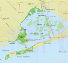
Rockaway Inlet is bounded by Brooklyn to the north and Rockaway Peninsula to the south. It is the entrance to Jamaica Bay, and most of the inlet is within the boundary of Gateway National Recreation Area. Its entrance is marked by a light on a jetty extending southward from Rockaway Point. The entrance channel extends westward of the jetty and is marked by lighted buoys. It has a depth of about 15 feet midchannel with a shoal of only one foot. In 1968 a light failed and the tanker Mary A. Whalen ran aground, resulting in a case entitled about dividing damage payments.[1]
The inlet is spanned by the Marine Parkway–Gil Hodges Memorial Bridge.
See also[]
- East Rockaway Inlet, separating the peninsula from Atlantic Beach
References[]
- ^ UNITED STATES, Petitioner, v. RELIABLE TRANSFER CO., INC. Cornell University Legal Information Institute
External links[]
Coordinates: 40°34′24″N 73°54′49″W / 40.5732°N 73.9136°W

This article about a location in Queens, New York is a stub. You can help Wikipedia by . |
This article about a location in Brooklyn, New York is a stub. You can help Wikipedia by . |
- Straits of Kings County, New York
- Straits of Queens County, New York
- Inlets of New York (state)
- Queens, New York geography stubs
- New York City geography stubs
- Long Island geography stubs