Long Island
Coordinates: 40°48′N 73°18′W / 40.8°N 73.3°W

Native name: Paumanok[1] | |
|---|---|
 Location of Long Island in New York State | |
 Long Island Location in United States | |
| Geography | |
| Location | Atlantic Ocean |
| Coordinates | 40°48′N 73°18′W / 40.8°N 73.3°W |
| Area | 1,376.1 sq mi (3,564 km2) |
| Highest elevation | 401 ft (122.2 m) |
| Highest point | Jayne's Hill |
| Administration | |
United States | |
| State | New York |
| Demographics | |
| Demonym | Long Islander |
| Population | 8,063,232 (2020) |
| Pop. density | 5,859.5/sq mi (2262.37/km2) |
| Ethnic groups | 54.7% White, 20.5% Hispanic or Latino of any race, 20.4% Black, 12.3% Asian, 8.8% other races, 3.2% from two or more races, 0.49% Native American, and 0.05% Pacific Islander |

| Part of a series on |
| Regions of New York |
|---|
 |
| Part of a series on |
| Long Island |
|---|
 |
| Topics |
|
| Regions |
|
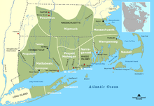
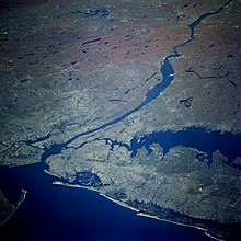
Long Island is a densely populated island in the southeast part of the U.S. state of New York, contained within the New York metropolitan area. At New York Harbor, it begins approximately 0.35 miles (0.56 km) east of Manhattan Island and extends eastward over 100 miles (160 km) into the Atlantic Ocean. The island comprises four counties; Kings and Queens counties (the New York City boroughs of Brooklyn and Queens, respectively) and Nassau County share the western third of the island, while Suffolk County occupies the eastern two thirds. More than half of New York City's residents live on Long Island, in Brooklyn and in Queens.[2] However, people in the New York metropolitan area colloquially use the term Long Island (or the Island) to refer exclusively to Nassau and Suffolk counties,[3] and conversely, employ the term the City to mean Manhattan alone.[4] While the Nassau-plus-Suffolk definition of Long Island does not have any legal existence, it is recognized as a "region" by the state of New York.[5]
Broadly speaking, "Long Island" may refer both to the main island and the surrounding outer barrier islands. To its west, Long Island is separated from Manhattan and the Bronx by the East River tidal estuary. North of the island is Long Island Sound, across which lie Westchester County, New York and the state of Connecticut. Across the Block Island Sound to the northeast is the state of Rhode Island. Block Island—which is part of Rhode Island—and numerous smaller islands extend further into the Atlantic. To the extreme southwest, Long Island is separated from Staten Island and the state of New Jersey by Upper New York Bay, the Narrows, and Lower New York Bay.
Both the longest and the largest island in the contiguous United States,[6] Long Island extends 118 miles (190 km) eastward from New York Harbor to Montauk Point, with a maximum north-to-south distance of 23 miles (37 km) between Long Island Sound and the Atlantic coast.[7] With a land area of 1,401 square miles (3,630 km2), Long Island is the 11th-largest island in the United States and the 149th-largest island in the world—larger than the 1,214 square miles (3,140 km2) of the smallest U.S. state, Rhode Island.[8]
With a census-estimated population of 8,036,232 residents as of the 2020 U.S. Census, constituting 40% of New York State's population,[9][10][11][12][13] Long Island is the most populated island in any U.S. state or territory, the third-most populous island in the Americas (after only Hispaniola and Cuba), and the 18th-most populous island in the world (ahead of Ireland, Jamaica, and Hokkaidō). Its population density is 5,595.1 inhabitants per square mile (2,160.3/km2). If Long Island geographically constituted an independent metropolitan statistical area, it would rank fourth most populous in the United States; while if it were a U.S. state, Long Island would rank thirteenth in population and first in population density. Long Island is culturally and ethnically diverse, featuring some of the wealthiest and most expensive neighborhoods in the world near the shorelines as well as working-class areas in all four counties.
As a hub of commercial aviation, Long Island is home to two of the New York City metropolitan area's three busiest airports, JFK International Airport and LaGuardia Airport, in addition to Islip MacArthur Airport; as well as two major air traffic control radar facilities, the New York TRACON and the New York ARTCC. Nine bridges and thirteen tunnels (including railroad tunnels) connect Brooklyn and Queens to the three other boroughs of New York City. Ferries connect Suffolk County northward across Long Island Sound to the state of Connecticut. The Long Island Rail Road is the busiest commuter railroad in North America and operates 24/7.[14] Nassau County high school students often feature prominently as winners of the Intel International Science and Engineering Fair and similar STEM-based academic awards.[15] Biotechnology companies and scientific research play a significant role in Long Island's economy,[16] including research facilities at Brookhaven National Laboratory, Cold Spring Harbor Laboratory, Stony Brook University, New York Institute of Technology, Plum Island Animal Disease Center, the New York University Tandon School of Engineering, the City University of New York, and Hofstra Northwell School of Medicine.
History[]
Early history[]
By the year 1643, there were 14 indigenous tribes living on Long Island: Canarsie, Rockaway, Matinecock, Merrick, Massapequa, Nissequoge, Secatoag, Seatauket, Patchoag, Unquechogue, has Corchaug, Shinnecock, Manhasset and Montauk.
They used canoes as a source of transportation, and since they lived by the shores, they went fishing.[17][better source needed] The fishermen used bows, arrows, and hooks to catch seafood such as crabs, scallops, and lobster.[18][better source needed] The farmers used fish for fertilizer and planted vegetables such as corn, beans, and squash, which were popular among the indigenous people. They were exceptional farmers; they had a great understanding of how the weather and soil affected the crops.[19][better source needed] Many of them hunted animals, such as deer, raccoon, and turkey in the forest.
The government that they set up was a participatory democracy and there was an alliance between the tribes. Each tribe had their own territory and chief that was respected by other tribes.[20] Prior to European contact, the Lenape people (named the Delaware by Europeans) inhabited the western end of Long Island, and spoke the Munsee dialect of Lenape, one of the Algonquian language family. The Lenape (who were part of the Shinnecock Tribe) practiced record keeping and used wooden tablets, trees, and stones to keep record. They also used wampum belts to write down important messages.[21] They also used their wampum to trade with the Europeans.[18] The Lenape people, in specific, were seen as peacemakers by other indigenous tribes, although they would defend themselves if necessary. The Europeans admired their friendliness and their skills in mediation.[22]
Giovanni da Verrazzano was the first European to record an encounter with the Lenapes, after entering what is now New York Bay in 1524. The island's eastern portion was inhabited by speakers of the Mohegan-Montauk-Narragansett language group of Algonquian languages; they were part of the Pequot and Narragansett peoples inhabiting the area that now includes Connecticut and Rhode Island.
In 1609, the English navigator Henry Hudson explored the harbor and purportedly landed at Coney Island. Dutch explorer Adriaen Block followed in 1615, and is credited as the first European to determine that both Manhattan and Long Island are islands.
In 1655, the European settlers purchased land from the Indigenous people. They split the land amongst themselves and continued to search the island for more land for settlement. Other parts of indigenous land were bought, areas that are now known as Brookhaven, Bellport, and South haven. These purchases occurred on June 10, 1664, the exchange was four coats and what is now $16.25.[17]
The white settlers and the indigenous people lived amicably together for a while. During King Philip's War in 1675, the English governor of New York ordered all canoes that were east of Hell Gate to be confiscated. This was done to prevent the Indigenous people from helping their allies in the mainland, who they were helping to attack the settlers.[23]
After the Dutch began to move into Manhattan many of the indigenous people moved to Pennsylvania and Delaware. Many of them who stayed behind died from smallpox as North Americans had never been exposed to the disease before, resulting in large scale deaths due to lack of antibodies and natural resistance which Eurasian peoples gained.[24]
Native American land deeds recorded by the Dutch from 1636 state that the Indians referred to Long Island as Sewanhaka (Sewanhacky and Sewanhacking were other spellings in the transliteration of Lenape).[25] Sewan was one of the terms for wampum (commemorative stringed shell beads, for a while also used as currency by colonists in trades with the Lenape), and is also translated as "loose" or "scattered", which may refer either to the wampum or to Long Island.[25] The name "'t Lange Eylandt alias Matouwacs" appears in Dutch maps from the 1650s.[26][27] Later, the English referred to the land as "Nassau Island",[28] after the Dutch Prince William of Nassau, Prince of Orange (who later also ruled as King William III of England). It is unclear when the name "Nassau Island" was discontinued. Another indigenous name from colonial time, Paumanok, comes from the Native American name for Long Island and means "the island that pays tribute."[29]

The very first European settlements on Long Island were by settlers from England and its colonies in present-day New England. Lion Gardiner settled nearby Gardiners Island. The first settlement on the geographic Long Island itself was on October 21, 1640, when Southold was established by the Rev. John Youngs and settlers from New Haven, Connecticut. Peter Hallock, one of the settlers, drew the long straw and was granted the honor to step ashore first. He is considered the first New World settler on Long Island. Southampton was settled in the same year. Hempstead followed in 1644, East Hampton in 1648, Huntington in 1653, Brookhaven in 1655, and Smithtown in 1665.

While the English eastern region of Long Island was first settled by the English, the western portion of Long Island was settled by the Dutch; until 1664, the jurisdiction of Long Island was split between the Dutch and English, roughly at the present border between Nassau County and Suffolk County. The Dutch founded six towns in present-day Brooklyn beginning in 1645. These included: Brooklyn, Gravesend, Flatlands, Flatbush, New Utrecht, and Bushwick. The Dutch had granted an English settlement in Hempstead, New York (now in Nassau County) in 1644, but after a boundary dispute they drove out English settlers from the Oyster Bay area. However, in 1664, the English returned to take over the Dutch colony of New Netherland, including Long Island.
The 1664 land patent granted to the Duke of York included all islands in Long Island Sound. The Duke of York held a grudge against Connecticut, as New Haven had hidden three of the judges (John Dixwell, Edward Whalley and William Goffe[30]) who sentenced the Duke's father, King Charles I, to death in 1649. Settlers throughout Suffolk County pressed to stay part of Connecticut, but Governor Sir Edmund Andros threatened to eliminate the settlers' rights to land if they did not yield, which they did by 1676.[31]
All of Long Island (as well as the islands between it and Connecticut) became part of the Province of New York within the Shire of York. Present-day Suffolk County was designated as the East Riding (of Yorkshire), present-day Brooklyn was part of the West Riding, and present-day Queens and Nassau were part of the larger North Riding. In 1683, Yorkshire was dissolved and the three original counties on Long Island were established: Kings, Queens, and Suffolk.
18th and 19th centuries[]
Early in the American Revolutionary War, the island was captured by the British from General George Washington in the Battle of Long Island, a decisive battle after which Washington narrowly evacuated his troops from Brooklyn Heights under a dense fog. After the British victory on Long Island, many Patriots fled, leaving mostly Loyalists behind. The island was a British stronghold until the end of the war in 1783.
General Washington based his espionage activities on Long Island, due to the western part of the island's proximity to the British military headquarters in New York City. The Culper Spy Ring included agents operating between Setauket and Manhattan. This ring alerted Washington to valuable British secrets, including the treason of Benedict Arnold and a plan to use counterfeiting to induce economic sabotage.
Long Island's colonists served both Loyalist and Patriot causes, with many prominent families divided among both sides. During the occupation British troops used a number of civilian structures for defense and demanded to be quartered in the homes of civilians. A number of structures from this era remain. Among these are Raynham Hall, the Oyster Bay home of patriot spy Robert Townsend, and the Caroline Church in Setauket, which contains bullet holes from a skirmish known as the Battle of Setauket. Also in existence is a reconstruction of Brooklyn's Old Stone House, on the site of the Maryland 400's celebrated last stand during the Battle of Long Island.

In the 19th century, Long Island was still mainly rural and devoted to agriculture. The predecessor to the Long Island Rail Road (LIRR) began service in 1836 from the South Ferry in Brooklyn, through the remainder of Brooklyn, to Jamaica in Queens. The line was completed to the east end of Long Island in 1844 (as part of a plan for transportation to Boston). Competing railroads (soon absorbed by the LIRR) were built along the south shore to accommodate travellers from those more populated areas. For the century from 1830 until 1930, total population roughly doubled every twenty years, with more dense development in areas near Manhattan. Several cities were incorporated, such as the 'City of Brooklyn' in Kings County, and Long Island City in Queens.
Until the 1883 completion of the Brooklyn Bridge, the only means of travel between Long Island and the rest of the United States was by boat or ship. As other bridges and tunnels were constructed, areas of the island began to be developed as residential suburbs, first around the railroads that offered commuting into the city. On January 1, 1898, Kings County and portions of Queens were consolidated into the 'City of Greater New York', abolishing all cities and towns within them. The easternmost 280 square miles (730 km2) of Queens County, which were not part of the consolidation plan,[32][33][34][35][36][37] separated from Queens in 1899 to form Nassau County.
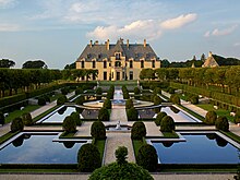
At the close of the 19th century, wealthy industrialists who made vast fortunes during the Gilded Age began to construct large "baronial" country estates in Nassau County communities along the North Shore of Long Island, favoring the many properties with water views. Proximity to Manhattan attracted such men as J. P. Morgan, William K. Vanderbilt, and Charles Pratt, whose estates led to this area being nicknamed the Gold Coast. This period and the area was immortalized in fiction, such as F. Scott Fitzgerald's The Great Gatsby, which has also been adapted in films.
20th century[]
Charles Lindbergh lifted off from Roosevelt Field with his Spirit of Saint Louis for his historic 1927 solo flight to Europe, one of the events that helped to establish Long Island as an early center of aviation during the 20th century. Other famous aviators such as Wiley Post originated notable flights from Floyd Bennett Field in Brooklyn, which became the first major airport serving New York City before it was superseded by the opening of La Guardia Airport in 1939. Long Island was also the site of Mitchel Air Force Base and was a major center of military aircraft production by companies such as Grumman and Fairchild Aircraft during World War II and for some decades afterward. Aircraft production on Long Island extended all the way into the Space Age – Grumman was one of the major contractors that helped to build the early lunar flight and space shuttle vehicles. Although the aircraft companies eventually ended their Long Island operations and the early airports were all later closed – Roosevelt Field, for instance, became the site of a major shopping mall – the Cradle of Aviation Museum on the site of the former Mitchel Field documents the Island's key role in the history of aviation.
From the 1920s to the 1940s, Long Island began the transformation from backwoods and farms as developers created numerous suburbs. Numerous branches of the LIRR already enabled commuting from the suburbs to Manhattan. Robert Moses engineered various automobile parkway projects to span the island, and developed beaches and state parks for the enjoyment of residents and visitors from the city. Gradually, development also followed these parkways, with various communities springing up along the more traveled routes.
After World War II, suburban development increased with incentives under the G.I. Bill, and Long Island's population skyrocketed, mostly in Nassau County and western Suffolk County. Second and third-generation children of immigrants moved out to eastern Long Island to settle in new housing developments built during the post-war boom. Levittown became noted as a suburb, where housing construction was simplified to be produced on a large scale. These provided opportunities for white World War II military veterans returning home to buy houses and start a family. In his 1966 book, My Private America (Moja prywatna Ameryka), Kazimierz Wierzyński, a Polish poet who could not go back to Poland after World War II, describes Polish farmers living there, as "walking novels".[38]
21st century[]
By the start of the 21st century, a number of Long Island communities had converted their assets from industrial uses to post-industrial roles. Brooklyn reversed decades of population decline and factory closings to resurface as a globally renowned cultural and intellectual hotbed. Gentrification has affected much of Brooklyn and a portion of Queens, relocating a sizeable swath of New York City's population. On eastern Long Island, such villages as Port Jefferson, Patchogue, and Riverhead have been changed from inactive shipbuilding and mill towns into tourist-centric commercial centers with cultural attractions.
The descendants of late 19th- and early 20th-century immigrants from southern and eastern Europe, and black migrants from the South, have been followed by more recent immigrants from Asia and Latin America. Long Island has many ethnic Irish, Jews, and Italians, as well as an increasing numbers of Asians and Hispanics, reflecting later migrations.
Geography[]


The westernmost end of Long Island contains the New York City boroughs of Brooklyn (Kings County) and Queens (Queens County). The central and eastern portions contain the suburban Nassau and Suffolk counties. However, colloquial usage of the term "Long Island" usually refers only to Nassau and Suffolk counties. For example, the Federal Reserve Bank of New York has a district named "Long Island (Nassau-Suffolk Metro Division)."[39] At least as late as 1911, locations in Queens were still commonly referred to as being on Long Island.[40] Some institutions in the New York City section of the island use the island's names, like Long Island University and Long Island Jewish Medical Center.
In 1985, the United States Supreme Court ruled in United States v. Maine that Long Island is integrally related to the mainland enough that Long Island Sound and the western part of Block Island Sound constitute a "juridicial bay" for the purpose of determining maritime state boundaries.[41] In the popular media this has been often misinterpreted as a ruling that Long Island is legally not an island.[42][43][44] The United States Board on Geographic Names still considers Long Island an island, because it is surrounded by water.[45]
There are few tall buildings on Long Island. Nassau County is more densely developed than Suffolk County. While affluent overall, Nassau County has pockets of more pronounced wealth with estates covering greater acreage within the Gold Coast of the North Shore and the Five Towns area on the South Shore. South Shore communities are built along protected wetlands of the island and contain white sandy beaches of Outer Barrier Islands fronting on the Atlantic Ocean. Dutch and English settlers from the time before the American Revolutionary War, as well as communities of Native Americans, populated the island. The 19th century saw the infusion of the wealthiest Americans in the so-called Gold Coast of the North Shore, where wealthy Americans and Europeans in the Gilded Age built lavish country homes.
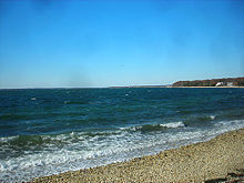
In its easternmost sections, Suffolk County remains semi-rural, as in Greenport on the North Fork and some of the periphery of the area prominently known as The Hamptons, although summer tourism swells the population in those areas. The North Fork peninsula of Suffolk County's East End has developed a burgeoning wine region.[46] In addition, the South Fork peninsula is known for beach communities, including the Hamptons, and for the Montauk Point Lighthouse at the eastern tip of the island. The Pine Barrens is a preserved pine forest encompassing much of eastern Suffolk County.

Geology[]
A detailed geomorphological study of Long Island provides evidence of glacial history of the kame and terminal moraines of the island which were formed by the advance and retreat of two ice sheets.[47] Long Island, as part of the Outer Lands region, is formed largely of two spines of glacial moraine, with a large, sandy outwash plain beyond. These moraines consist of gravel and loose rock left behind during the two most recent pulses of Wisconsin glaciation during the ice ages some 21,000 years ago (19,000 BC). The northern moraine, which directly abuts the North Shore of Long Island at points, is known as the Harbor Hill moraine. The more southerly moraine, known as the Ronkonkoma moraine, forms the "backbone" of Long Island; it runs primarily through the very center of Long Island, roughly coinciding with the length of the Long Island Expressway.
The land to the south of this moraine to the South Shore is the outwash plain of the last glacier. One part of the outwash plain was known as the Hempstead Plains, and this land contained one of the few natural prairies to exist east of the Appalachian Mountains.[48] The glaciers melted and receded to the north, resulting in the difference between the topography of the North Shore beaches and the South Shore beaches. The North Shore beaches are rocky from the remaining glacial debris, while the South Shore's are crisp, clear, outwash sand. Jayne's Hill, at 401 feet (122 m), within Suffolk County near its border with Nassau County, is the highest hill along either moraine; another well-known summit is Bald Hill in Brookhaven Town, not far from its geographical center at Middle Island. The glaciers also formed Lake Ronkonkoma in Suffolk County and Lake Success in Nassau County, each a deep kettle lake.
Countyscapes[]


Climate[]
Under the Köppen climate classification, Long Island lies in a transition zone between a humid subtropical climate (Cfa/Do) and a hot-summer humid continental climate (Dfa).[50] The climate features hot, usually humid summers with occasional thunderstorms, mild spring and fall weather, and cold winters with a mix of snow and rain and stormier conditions. Spring can be cool due to the relatively cooler temperatures of the Atlantic Ocean and occasional blocking. Thunderstorms rarely form directly over Long Island, but can form over inland areas and then move eastward. Some storms may weaken as they approach Long Island due to the moderating effects of the Atlantic Ocean. The ocean also brings afternoon sea breezes to the immediate South Shore areas (within 1 mile (1.6 km)) that temper the heat in the warmer months. The temperatures south of Sunrise Highway (NY Route 27) tend to be significantly cooler than the rest of Long Island in the spring and summer months because of the relatively cooler temperatures of the Atlantic Ocean. Long Island has a moderately sunny climate, averaging 2,400 to 2,800 hours of sunshine annually.[51]

Due to its coastal location, Long Island winter temperatures are milder than most of the state. The coldest month is January, when average temperatures range from 25 to 45 °F (−4 to 7 °C), and the warmest month is July, when average temperatures range from 74 to 85 °F (23 to 29 °C).[52] Temperatures seldom fall below −5 °F (−21 °C) or rise above 100 °F (38 °C). Coldest temp ever recorded on Long Island was −14 °F (−26 °C) in February 1967. Long Island temperatures vary from west to east, with the western part (Nassau County, Queens, and Brooklyn) generally 2 to 3 degrees F (1 to 2 degrees C) warmer than the east (Suffolk County). This is due to several factors: the western part is closer to the mainland and more densely developed, causing the "urban heat island" effect, and Long Island's land mass veers northward as one travels east. Also, daytime high temperatures on the eastern part of Long Island are cooler on most occasions, due to the moderating effect of the Atlantic Ocean and Long Island Sound. On dry nights with no clouds or wind, the Central Part of Suffolk County and Pine Barrens forest of eastern Suffolk County can be almost 5 to 10 F (3 to 5 C) cooler than the rest of the island, due to radiational cooling. Average dew points, a measure of atmospheric moisture, typically lie in the 60–70 °F (16–21 °C) range during July and August.

Precipitation is distributed uniformly throughout the year, with approximately 3–4 inches (76–102 mm) on average during each month. Average yearly snowfall totals range from approximately 20 to 35 inches (51 to 89 cm), with the north shore and western parts averaging more than the immediate south shore (South of Sunrise Hwy) and the east end. In any given winter, however, some parts of the island can see up to 50 inches (130 cm) of snow or more. There are also milder winters, in which much of the island see less than 10 inches (25 cm) of snow.
On August 13, 2014, flash flooding occurred in western-central Suffolk County after a record-setting rainfall deposited more than three months' worth of precipitation on the area within a few hours.[53]
Long Island is somewhat vulnerable to tropical cyclones.[54] While it lies north of where most tropical cyclones turn eastward and out to sea (most landfalls on the East Coast of the USA occur from North Carolina southward), several tropical cyclones have struck Long Island, including a devastating Category 3, the 1938 New England Hurricane (also known as the "Long Island Express"), and another Category 3, Hurricane Carol in 1954. Other 20th-century storms that made landfall on Long Island at hurricane intensity include the Great Atlantic Hurricane of 1944, Hurricane Donna in 1960, Hurricane Belle in 1976, and Hurricane Gloria in 1985. Also, the eyewall of Hurricane Bob in 1991 brushed the eastern tip. In August 2011, portions of Long Island were evacuated in preparation for Hurricane Irene, a Category 1 hurricane which weakened to a tropical storm before it reached Long Island.[55]
On October 29, 2012, Hurricane Sandy caused extensive damage to low-lying coastal areas of Nassau and Suffolk counties, Brooklyn, and Queens, destroying or severely damaging thousands of area homes and other structures by ocean and bay storm surges. Hundreds of thousands of residents were left without electric power for periods of time ranging up to several weeks while the damage was being repaired. The slow-moving "Superstorm Sandy" (so-nicknamed because it merged with a nor'easter before it made landfall) caused 90% of Long Island households to lose power and an estimated $18 billion in damages in Nassau and Suffolk counties alone.[56][57] The storm also had a devastating impact on coastal communities in the Brooklyn and Queens portions of the island, including Coney Island in Brooklyn and the Rockaway Peninsula in Queens, although estimates of monetary damages there are usually calculated as part of the overall losses suffered in New York City as a whole. When allowance is made for inflation, the extent of Sandy's damages is second only to that of those caused by the 1938 Long Island Express. Although a lower central pressure was recorded in Sandy, the National Hurricane Center estimates that the 1938 hurricane had a lower pressure at landfall.[58][59][full citation needed] Hurricane Sandy and its profound impacts have prompted the discussion of constructing seawalls and other coastal barriers around the shorelines of Long Island and New York City to minimize the risk of destructive consequences from another such event in the future.[60][61]
| hideClimate data for Islip, New York (Long Island MacArthur Airport), 1991–2020 normals,[a] extremes 1963–present | |||||||||||||
|---|---|---|---|---|---|---|---|---|---|---|---|---|---|
| Month | Jan | Feb | Mar | Apr | May | Jun | Jul | Aug | Sep | Oct | Nov | Dec | Year |
| Record high °F (°C) | 69 (21) |
68 (20) |
82 (28) |
94 (34) |
98 (37) |
96 (36) |
104 (40) |
100 (38) |
94 (34) |
89 (32) |
78 (26) |
77 (25) |
104 (40) |
| Mean maximum °F (°C) | 58 (14) |
57 (14) |
67 (19) |
77 (25) |
85 (29) |
90 (32) |
94 (34) |
91 (33) |
86 (30) |
79 (26) |
69 (21) |
61 (16) |
96 (36) |
| Average high °F (°C) | 39.2 (4.0) |
41.0 (5.0) |
47.7 (8.7) |
58.3 (14.6) |
68.3 (20.2) |
77.2 (25.1) |
82.8 (28.2) |
81.4 (27.4) |
74.8 (23.8) |
64.1 (17.8) |
53.6 (12.0) |
44.4 (6.9) |
61.1 (16.2) |
| Daily mean °F (°C) | 31.9 (−0.1) |
33.3 (0.7) |
39.9 (4.4) |
49.7 (9.8) |
59.5 (15.3) |
69.0 (20.6) |
75.0 (23.9) |
73.7 (23.2) |
66.9 (19.4) |
55.7 (13.2) |
45.6 (7.6) |
37.1 (2.8) |
53.1 (11.7) |
| Average low °F (°C) | 24.6 (−4.1) |
25.5 (−3.6) |
32.0 (0.0) |
41.2 (5.1) |
50.8 (10.4) |
60.9 (16.1) |
67.3 (19.6) |
66.0 (18.9) |
58.9 (14.9) |
47.3 (8.5) |
37.6 (3.1) |
29.8 (−1.2) |
45.2 (7.3) |
| Mean minimum °F (°C) | 7 (−14) |
10 (−12) |
17 (−8) |
29 (−2) |
38 (3) |
48 (9) |
58 (14) |
56 (13) |
45 (7) |
33 (1) |
23 (−5) |
16 (−9) |
5 (−15) |
| Record low °F (°C) | −8 (−22) |
−14 (−26) |
0 (−18) |
16 (−9) |
32 (0) |
42 (6) |
49 (9) |
45 (7) |
38 (3) |
23 (−5) |
11 (−12) |
−1 (−18) |
−14 (−26) |
| Average precipitation inches (mm) | 3.66 (93) |
3.29 (84) |
4.51 (115) |
4.06 (103) |
3.28 (83) |
4.00 (102) |
3.26 (83) |
4.24 (108) |
3.60 (91) |
3.97 (101) |
3.41 (87) |
4.71 (120) |
45.99 (1,168) |
| Average snowfall inches (cm) | 10.3 (26) |
9.4 (24) |
6.5 (17) |
0.6 (1.5) |
0.0 (0.0) |
0.0 (0.0) |
0.0 (0.0) |
0.0 (0.0) |
0.0 (0.0) |
0.0 (0.0) |
0.5 (1.3) |
4.5 (11) |
31.8 (81) |
| Average precipitation days (≥ 0.01 in) | 11.1 | 9.9 | 10.8 | 11.3 | 11.6 | 10.1 | 9.1 | 8.9 | 8.6 | 9.2 | 9.6 | 11.8 | 122.0 |
| Average snowy days (≥ 0.1 in) | 3.8 | 3.7 | 2.7 | 0.3 | 0.0 | 0.0 | 0.0 | 0.0 | 0.0 | 0.0 | 0.3 | 2.6 | 13.4 |
| Source: NOAA[62][63] | |||||||||||||
| hideClimate data for Montauk, New York (1981–2010 normals, extremes 1998-present) | |||||||||||||
|---|---|---|---|---|---|---|---|---|---|---|---|---|---|
| Month | Jan | Feb | Mar | Apr | May | Jun | Jul | Aug | Sep | Oct | Nov | Dec | Year |
| Record high °F (°C) | 64 (18) |
59 (15) |
71 (22) |
89 (32) |
86 (30) |
92 (33) |
98 (37) |
98 (37) |
91 (33) |
84 (29) |
71 (22) |
70 (21) |
98 (37) |
| Average high °F (°C) | 38.1 (3.4) |
40.1 (4.5) |
45.6 (7.6) |
54.5 (12.5) |
64.2 (17.9) |
73.3 (22.9) |
79.3 (26.3) |
78.9 (26.1) |
71.9 (22.2) |
62.6 (17.0) |
53.0 (11.7) |
43.6 (6.4) |
58.8 (14.9) |
| Daily mean °F (°C) | 32.3 (0.2) |
33.7 (0.9) |
39.0 (3.9) |
47.5 (8.6) |
56.6 (13.7) |
66.4 (19.1) |
72.4 (22.4) |
72.2 (22.3) |
65.7 (18.7) |
56.4 (13.6) |
47.2 (8.4) |
37.9 (3.3) |
52.3 (11.3) |
| Average low °F (°C) | 26.4 (−3.1) |
27.3 (−2.6) |
32.4 (0.2) |
40.4 (4.7) |
48.9 (9.4) |
59.5 (15.3) |
65.5 (18.6) |
65.5 (18.6) |
59.4 (15.2) |
50.3 (10.2) |
41.4 (5.2) |
32.3 (0.2) |
45.8 (7.7) |
| Record low °F (°C) | 5 (−15) |
−2 (−19) |
8 (−13) |
25 (−4) |
31 (−1) |
43 (6) |
51 (11) |
54 (12) |
39 (4) |
30 (−1) |
19 (−7) |
12 (−11) |
−2 (−19) |
| Average precipitation inches (mm) | 2.87 (73) |
3.38 (86) |
4.75 (121) |
3.45 (88) |
2.21 (56) |
3.80 (97) |
3.81 (97) |
3.92 (100) |
3.93 (100) |
3.66 (93) |
4.22 (107) |
3.58 (91) |
43.58 (1,109) |
| Source: NOAA[69] | |||||||||||||
Additional islands[]
Several smaller islands, though geographically distinct, are in proximity to Long Island and are often grouped with it. These islands include Fire Island, the largest of the outer barrier islands that parallels the southern shore of Long Island for approximately 31 miles (50 km); Plum Island, which was home to the Plum Island Animal Disease Center, a biological weapons research facility; as well as Robins Island, Gardiners Island, Fishers Island, Long Beach Barrier Island, Jones Beach Island, Great Gull Island, Little Gull Island, and Shelter Island.
Demographics[]

| Historical population | |||
|---|---|---|---|
| Census | Pop. | %± | |
| 1790 | 37,108 | — | |
| 1800 | 42,907 | 15.6% | |
| 1810 | 48,752 | 13.6% | |
| 1820 | 56,978 | 16.9% | |
| 1830 | 69,775 | 22.5% | |
| 1840 | 110,406 | 58.2% | |
| 1850 | 212,637 | 92.6% | |
| 1860 | 379,788 | 78.6% | |
| 1870 | 540,648 | 42.4% | |
| 1880 | 743,957 | 37.6% | |
| 1890 | 1,029,097 | 38.3% | |
| 1900 | 1,452,611 | 41.2% | |
| 1910 | 2,098,460 | 44.5% | |
| 1920 | 2,723,764 | 29.8% | |
| 1930 | 4,103,638 | 50.7% | |
| 1940 | 4,600,022 | 12.1% | |
| 1950 | 5,237,918 | 13.9% | |
| 1960 | 6,403,852 | 22.3% | |
| 1970 | 7,141,515 | 11.5% | |
| 1980 | 6,728,074 | −5.8% | |
| 1990 | 6,861,474 | 2.0% | |
| 2000 | 7,448,618 | 8.6% | |
| 2010 | 7,568,304 | 1.6% | |
| 2020 | 8,063,232 | 6.5% | |
Long Island is one of the most densely populated regions in the United States. At the 2020 U.S. census, the total population of all four counties of Long Island was 8,063,232, comprising 40% of the population of the State of New York. As of 2020, the proportion of New York City residents (total 8,804,190) living on Long Island had risen to 58.4%, given the 5,141,538 residents living in Brooklyn or Queens.[2] Furthermore, the proportion of New York State's population residing on Long Island has also been increasing, with Long Island's Census-estimated population increasing 6.5% since 2010, to 8,063,232 in 2020, representing 40% of New York State's Census 2020-enumerated population of 20,215,751[78] and with a population density of 5,859.5 inhabitants per square mile (2,262.4/km2) on Long Island; the island is more populous than 37 of the 50 U.S. states.
At the 2020 census, the combined population of Nassau and Suffolk counties was 2,921,694 people, Suffolk County's share being 1,525,920 and Nassau County's 1,395,774. Nassau County had a larger population for decades, but Suffolk County surpassed it in the 1990 census as growth and development continued to spread eastward. As Suffolk County has more than three times the land area of Nassau County, the latter still has a much higher population density, given its proximity to New York City. According to the U.S. Census Bureau's 2008 American Community Survey, Nassau and Suffolk counties had the 10th and 26th highest median household incomes in the nation, respectively.[79]
Population figures from the U.S. Census Bureau Census 2010[80] show that whites are the largest racial group in all four counties, and are in the majority in Nassau and Suffolk counties. In 2002, The New York Times cited a study by the non-profit group ERASE Racism, which determined that Nassau and Suffolk counties constitute the most racially segregated suburbs in the United States.[81]
In contrast, Queens is the most ethnically diverse county in the United States and the most diverse urban area in the world.[82][83]
According to a 2000 report on religion, which asked congregations to respond, Catholics are the largest religious group on Long Island, with non-affiliated in second place. Catholics make up 52% of the population of Nassau and Suffolk, versus 22% for the country as a whole, with Jews at 16% and 7%, respectively, versus 1.7% nationwide.[84] Only a small percentage of Protestants responded, 7% and 8% respectively, for Nassau and Suffolk counties. This is in contrast with 23% for the entire country on the same survey, and 50% on self-identification surveys.[84]
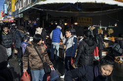
A growing population of nearly half a million Chinese Americans now live on Long Island.[71] Rapidly expanding Chinatowns have developed in Brooklyn (布魯克林) and Queens, with Chinese immigrants also moving into Nassau County,[85][86][87] as did earlier European immigrants, such as the Irish and Italians. The busy intersection of Main Street, Kissena Boulevard, and 41st Avenue defines the center of Downtown Flushing and the Flushing Chinatown, known as the "Chinese Times Square" or the "Chinese Manhattan".[88][89] The segment of Main Street between Kissena Boulevard and Roosevelt Avenue, punctuated by the Long Island Rail Road trestle overpass, represents the cultural heart of the Flushing Chinatown. Housing over 30,000 individuals born in China alone, the largest by this metric outside Asia, Flushing has become home to the largest and one of the fastest-growing Chinatowns in the world as the heart of over 250,000 ethnic Chinese in Queens, representing the largest Chinese population of any U.S. municipality other than New York City in total.[90] Conversely, the Flushing Chinatown has also become the epicenter of organized prostitution in the United States, importing women from China, Korea, Thailand, and Eastern Europe to sustain the underground North American sex trade.[91] Flushing is undergoing rapid gentrification with investment by Chinese transnational entities,[92]
More recently, a Little India community has emerged in Hicksville, Nassau County,[93] spreading eastward from the more established Little India enclaves in Queens. Rapidly growing Chinatowns have developed in Brooklyn and Queens,[94][95][87] as did earlier European immigrants, such as the Irish and Italians. As of 2019, the Asian population in Nassau County had grown by 39% since 2010 to an estimated 145,191 individuals, including approximately 50,000 Indian Americans and 40,000 Chinese Americans, as Nassau County has become the leading suburban destination in the U.S. for Chinese immigrants.[96] Likewise, the Long Island Koreatown originated in Flushing, Queens, and is expanding eastward along Northern Boulevard[97][98][99][100][101] and into Nassau County.[87][98][99]
Long Island is home to two Native American reservations, Poospatuck Reservation, and Shinnecock Reservation, both in Suffolk County. Numerous island place names are Native American in origin.
A 2010 article in The New York Times stated that the expansion of the immigrant workforce on Long Island has not displaced any jobs from other Long Island residents. Half of the immigrants on Long Island hold white-collar positions.[102]
The counties of Nassau and Suffolk have been long renowned for their affluence. Long Island is home to some of the wealthiest communities in the United States, including The Hamptons, on the East End of the South Shore of Suffolk County; the Gold Coast, in the vicinity of the island's North Shore, along Long Island Sound; and increasingly, the western shoreline of Brooklyn, facing Manhattan. In 2016, according to Business Insider, the 11962 zip code encompassing Sagaponack, within Southampton, was listed as the most expensive in the U.S., with a median home sale price of $8.5 million.[103]
Economy[]
This section does not cite any sources. (November 2013) |
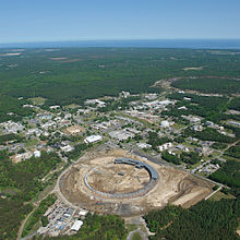
Long Island has played a prominent role in scientific research and in engineering. It is the home of the Brookhaven National Laboratory in nuclear physics and Department of Energy research. Long Island is also home to the Cold Spring Harbor Laboratory, which was directed for 35 years by James D. Watson (who, along with Francis Crick and Rosalind Franklin, discovered the double helix structure of DNA). Companies such as Sperry Rand, Computer Associates (headquartered in Islandia), Zebra Technologies (now occupying the former headquarters of Symbol Technologies, and a former Grumman plant in Holtsville), have made Long Island a center for the computer industry. Stony Brook University and New York Institute of Technology conduct advanced medical and technological research.
Long Island is home to the East Coast's largest industrial park, the Hauppauge Industrial Park, hosting over 1,300 companies which employ more than 71,000 individuals. Companies in the park and abroad are represented by the Hauppauge Industrial Association. As many as 20% of Long Islanders commute to jobs in Manhattan. The island's eastern end is still partly agricultural. Development of vineyards on the North Fork has spawned a major viticultural industry, replacing potato fields. Pumpkin farms have been added to traditional truck farming. Farms allow fresh fruit picking by Long Islanders for much of the year. Fishing continues to be an important industry, especially at Huntington, Northport, Montauk, and other coastal communities of the East End and South Shore.
From about 1930 to about 1990, Long Island was considered one of the aerospace manufacturing centers of the United States, with companies such as Grumman Aircraft, Republic, Fairchild, and Curtiss having their headquarters and factories on Long Island. These operations have largely been phased out or significantly diminished.
Government and politics[]

Nassau County and Suffolk County each have their own governments, with a County Executive leading each. Each has a county legislature and countywide-elected officials, including district attorney, county clerk, and county comptroller. The towns in both counties have their own governments as well, with town supervisors and a town council. Nassau County is divided into three towns and two small incorporated cities (Glen Cove and Long Beach). Suffolk County is divided into ten towns.
Brooklyn and Queens, on the other hand, do not have county governments. As boroughs of New York City, both have borough presidents, which have been largely ceremonial offices since the shutdown of the New York City Board of Estimate. The respective Borough Presidents are responsible for appointing individuals to the Brooklyn Community Boards and Queens Community Boards, each of which serves an advisory function on local issues. Brooklyn's sixteen members and Queens' fourteen members represent the first and second largest borough contingents of the New York City Council.[104]
Law enforcement[]
Queens and Brooklyn are patrolled by the New York City Police Department. Nassau and Suffolk counties are served by the Nassau County Police Department and Suffolk County Police Department, respectively, although several dozen villages and the two cities in Nassau County have their own police departments. The Nassau County Sheriff's Department and Suffolk County Sheriff's Office handle civil procedure, evictions, warrant service and enforcement, prisoner transport and detention, and operation of the county jail. The Suffolk County Sheriff also has a patrol division, and in 2008, had patrol duties along the Long Island Expressway, when the County Executive briefly disbanded the Suffolk County Police Highway Patrol Division.New York State Police patrol state parks and parkways, with the exception of the Long Island Expressway, which is an interstate patrolled by County Police. The several SUNY colleges and universities are patrolled by the New York State University Police.
Statehood proposals[]
The secession of Nassau and Suffolk counties on Long Island from New York State was proposed as early as 1896, but talk was revived towards the latter part of the twentieth century.[105] On March 28, 2008, Suffolk County Comptroller Joseph Sawicki proposed a plan that would make Nassau and Suffolk counties on Long Island the 51st state of the United States of America.[106] Sawicki claimed all of Nassau and Suffolk taxpayers' money would remain locally, rather than the funds being dispersed all over the entire state of New York, with these counties sending to Albany over three billion dollars more than they receive.[107] The state of Long Island would have included nearly 3 million people (a larger population than that of fifteen other states). Nassau County executive Ed Mangano came out in support of such a proposal in April 2010 and commissioned a study on it.[108]
Education[]
Primary and secondary education[]

Many public and private high schools on Long Island are ranked among the best in the United States.[109][110] Nassau and Suffolk counties are the home of 125 public school districts containing 656 public schools. It also hosts private schools such as Friends Academy, Chaminade High School, Kellenberg Memorial High School, St. Anthony's High School, and North Shore Hebrew Academy, as well as parochial schools, many of which are operated by the Catholic Diocese of Rockville Centre.
In contrast, all of Brooklyn and Queens are served by the New York City Department of Education, the largest school district in the United States. Three of the nine specialized high schools in New York City are in the two Long Island boroughs, those being Brooklyn Latin School, Brooklyn Technical High School (one of the original three specialized schools), and Queens High School for the Sciences. Like Nassau and Suffolk counties, they are home to private schools such as Poly Prep Country Day School, Packer Collegiate Institute, and Saint Ann's School, and Berkeley Carroll School, and parochial schools operated by the Catholic Diocese of Brooklyn.
Colleges and universities[]

Long Island is home to a range of higher-education institutions, both public and private. Brooklyn and Queens contain five of eleven senior colleges within CUNY, the public university system of New York City and one of the largest in the country. Among these are the notable institutions of Brooklyn College and Queens College. Brooklyn also contains private colleges such as Pratt Institute and the New York University Polytechnic School of Engineering, an engineering college that merged with New York University in 2014.
Several colleges and universities within the State University of New York system are on Long Island, including Stony Brook University (which noted its health sciences research and medical center), as well as Nassau Community College and Suffolk County Community College that serve their respective counties. Private institutions include Molloy College in Rockville Centre, the New York Institute of Technology, Hofstra University and Adelphi University (both in the Town of Hempstead), as well as Long Island University (with its C.W. Post campus, on a former Gold Coast estate in Brookville, and a satellite campus in downtown Brooklyn). Long Island also contains the Webb Institute, a small naval architecture college in Glen Cove. The island is also home to the United States Merchant Marine Academy, a Federal Service Academy in Kings Point, on the North Shore.
Culture[]
Music[]

Music on Long Island (Nassau and Suffolk) is strongly influenced by the proximity to New York City and by the youth culture of the suburbs. Psychedelic rock was widely popular in the 1960s as flocks of disaffected youth travelled to NYC to participate in protest and the culture of the time. R & B also has a history on Long Island, most notably Huntington-born Mariah Carey, one of the top-selling musicians of all time. In the late 1970s through the 1980s, the influence of radio station WLIR made Long Island one of the first places in the U.S. to hear and embrace European New Wave bands such as Depeche Mode, the Pet Shop Boys, and Culture Club. In the 1990s, hip-hop became popular with rap pioneers Rakim, EPMD, MF Doom, and Public Enemy growing up on Long Island. Long Island was the home of a bustling emo scene in the 2000s, with bands such as Brand New, Taking Back Sunday, Straylight Run, From Autumn to Ashes and As Tall as Lions.[111] More recently, newer acts from Long Island, including Austin Schoeffel, Jon Bellion, and Envy on the Coast, have made a name for themselves.
Famous rock bands from Long Island include The Rascals, The Ramones (from Queens), Dream Theater, Blue Öyster Cult, Twisted Sister, and guitar virtuosos Donald (Buck Dharma) Roeser, John Petrucci, Steve Vai and Joe Satriani, as well as drummer Mike Portnoy. Rock and pop singer Billy Joel grew up in Hicksville, and his music often reflects Long Island and his youth.
National The Nassau Coliseum and Northwell Health at Jones Beach Theater are venues used by national touring acts as performance spaces for concerts. Northwell Health at Jones Beach Theater is an outdoor amphitheatre at Jones Beach State Park. It is a popular place to view summer concerts that feature new and classic artists. It hosts a large Fourth of July fireworks show every year which fills the stands. People also park cars along the highway leading to the show, and others watch from the nearby beaches.[112]
Long Island is also known for its school music programs. Many schools in Suffolk County have distinguished music programs, with high numbers of students who are accepted into the statewide All-State music groups, or even the National All-Eastern Coast music groups. Both the Suffolk County and Nassau County Music Educator's Associations are recognized by The National Association for Music Education (NAfME),[113][114] and host numerous events, competitions, and other music-related activities.
Cuisine[]
Long Island has historically been a center for fishing and seafood. This legacy continues in the Blue Point oyster, a now ubiquitous variety originally harvested on the Great South Bay that was the favorite oyster of Queen Victoria. Clams are also a popular food and clam digging a popular recreational pursuit, with Manhattan clam chowder reputed to have Long Island origins.[115]

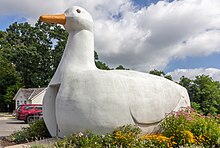
Of land-based produce, Long Island duck has a history of national recognition since the 19th century, with four duck farms continuing to produce 2 million ducks a year as of 2013.[116] Two symbols of Long Island's duck farming heritage are the Long Island Ducks minor-league baseball team and the Big Duck, a 1931 duck-shaped building that is a historic landmark and tourist attraction. In addition to Long Island's duck industry, Riverhead contains one of the largest buffalo farms on the East coast.[117]
Long Island is well known for its production of alcoholic beverages. Eastern Long Island is a significant producer of wine. Vineyards are most heavily concentrated on Long Island's North Fork, which contains 38 wineries. Most of these contain tasting rooms, which are popular attractions for visitors from across the New York metropolitan area.[118] Long Island has also become a producer of diverse craft beers, with 15 microbreweries across Nassau and Suffolk counties as of 2013. The largest of these is Blue Point Brewing Company, best known for its toasted lager.[119] Long Island is also globally known for its signature cocktail, the Long Island Iced Tea, which was purportedly invented at the popular Babylon, Oak Beach Inn nightclub in the 1970s.[120]
Long Island's eateries are largely a product of the region's local ethnic populations. Asian cuisines, Italian cuisine, Jewish cuisine, and Latin American cuisines were the most popular ethnic cuisines on Long Island as of the second decade of the 2000s.[121][122] Asian cuisines are predominantly represented by East Asian, South Asian, and Middle Eastern cuisines.[121] Italian cuisine is found in ubiquitous pizzerias throughout the island, with the region hosting an annual competition, the Long Island Pizza Festival & Bake-Off. Jewish cuisine is likewise represented by delicatessens and bagel stores. Latin American cuisines span their geographical origins,[122] from Brazilian rodizios to Mexican taquerias.
Sports[]
Major league sports[]

The New York Mets baseball team plays at Citi Field in Flushing Meadows-Corona Park, Queens. Their former stadium, Shea Stadium was also home for the New York Jets football team from 1964 until 1983. The new stadium has an exterior façade and main entry rotunda inspired by Brooklyn's famous Ebbets Field (see below). The New York Mets planned to move their Double-A farm team to Long Island, as part of the ambitious but now-defunct plan for Nassau County called The Lighthouse Project. The Brooklyn Cyclones are a minor league baseball team, affiliated with the New York Mets. The Cyclones play at MCU Park just off the boardwalk on Coney Island in Brooklyn. An artificial turf baseball complex named Baseball Heaven is in Yaphank.

The Barclays Center, a sports arena, business, and residential complex built partly on a platform over the Atlantic Yards at Atlantic Avenue in Brooklyn, is the home of the Brooklyn Nets basketball team and the New York Islanders hockey team. The move from New Jersey in the summer of 2012 marked the return to Long Island for the Nets franchise, which played at Nassau Veterans Memorial Coliseum in Uniondale from 1972 to 1977. The Islanders played at Nassau Coliseum from their 1972 inception through 2015, and then splitting time between Nassau Coliseum and Barclays Center from 2017 to 2020, playing their last full season at the Nassau Coliseum during the 2020-2021 NHL Season. The Islanders anticipate moving full-time to a new hockey arena at Belmont Park, in Elmont, NY, in 2022.
Ebbets Field, which stood in Brooklyn from 1913 until its demolition in 1960, was the home of the Brooklyn Dodgers baseball team, who moved to California after the 1957 Major League Baseball season to become the Los Angeles Dodgers. The Dodgers won several National League pennants in the 1940s and 1950s, losing several times in the World Series—often called Subway Series—to their Bronx rivals, the New York Yankees. The Dodgers won their lone championship in Brooklyn in the 1955 World Series versus the Yankees.
Despite this success during the latter part of the team's stay in Brooklyn, they were a second-division team with an unspectacular winning record for much of their history there – but nonetheless became legendary for the almost-fanatical devotion of the Brooklynites who packed the relatively small ballpark to vigorously root for the team they affectionately called, "Dem Bums". Loss of the Dodgers to California was locally considered a civic tragedy that negatively affected the community far more than the similar moves of other established teams to new cities in the 1950s, including the Dodgers' long-time arch-rival New York Giants, who also left for California after 1957.
Minor league and college sports[]


The Stony Brook Seawolves represent Stony Brook University, and have had a bevy of athletic accomplishments such as reaching the 2012 College World Series as an underdog after defeating the LSU Tigers in a best-of-3 series.
Long Island is also home to the Long Island Ducks minor league baseball team of the Atlantic League. Their stadium, Bethpage Ballpark, is in Central Islip. The Brooklyn Cyclones minor league baseball team, affiliated with the New York Mets, plays in the Short-Season A classification New York–Penn League. The Cyclones play at MCU Park just off the Coney Island Boardwalk in the New York City borough of Brooklyn. The New York Dragons of the Arena Football League played their home games at Nassau Coliseum.The two main rugby union teams are the in East Meadow and the in Stony Brook.
The New York Sharks is a women's American football team that is a member of the Women's Football Alliance.The New York Sharks home field is at Aviator Sports Complex in Brooklyn.
Long Island's professional soccer club, the New York Cosmos, play in the Division 2 North American Soccer League at James M. Shuart Stadium in Hempstead.
Long Island has historically been a hotbed of lacrosse at the youth and college level, which made way for a Major League Lacrosse team in 2001, the Long Island Lizards. The Lizards play at Mitchel Athletic Complex in Uniondale.
Other sports[]
Long Island has a wide variety of golf courses found all over the island. Two of the most well-known are the Shinnecock Hills Golf Club and the public Bethpage Black Course that has hosted multiple U.S. Open tournaments as well as several other top level international championships. Queens also hosts one of the four tennis grand slams, the US Open. Every August (September, in Olympic years) the best tennis players in the world travel to Long Island to play the championships held in the USTA National Tennis Center, adjacent to Citi Field in Flushing Meadows Park. The complex also contains the biggest tennis stadium in the world, the Arthur Ashe Stadium.

Long Island also has two horse racing tracks, Aqueduct Racetrack in Ozone Park, Queens and Belmont Park on the Queens/Nassau border in Elmont, home of the Belmont Stakes. The longest dirt thoroughbred racecourse in the world is also at Belmont Park. Another category of sporting events popular in this region involves firematic racing events, involving many local volunteer fire departments.
Notable sportspeople and teams[]
Long Island is home to numerous famous athletes, including Hall of Famers Jim Brown, Julius Erving, John Mackey, Whitey Ford, Nick Drahos, and Carl Yastrzemski. Others include gold medalists Sue Bird, Sarah Hughes and Derrick Adkins, USWNT World Cup champions Crystal Dunn and Alexandra Long, D'Brickashaw Ferguson, Billy Donovan, Larry Brown, Rick Pitino, John McEnroe, Jumbo Elliott, Mick Foley, Zack Ryder, Matt Serra, Boomer Esiason, Vinny Testaverde, Craig Biggio, Frank Catalanotto, Greg Sacks, Gilles Villemure, Rob Burnett, Steve Park, Frank Viola, Chris Weidman, Marques Colston and Speedy Claxton.
Several NHL players were born and/or raised on Long Island, such as Vancouver Canucks Christopher Higgins and Matt Gilroy, Nashville Predators Eric Nystrom, Toronto Maple Leaf Mike Komisarek, Pittsburgh Penguin Rob Scuderi, and New Jersey Devil Keith Kinkaid. Both Komisarek and Higgins played on the same Suffolk County Hockey League team at an early age, and later played on the Montreal Canadiens together. Nick Drahos was an All Scholastic and All Long Island honoree at Lawrence High School, Nassau Co. in 1936 and 1937, and a two-time Unanimous National College All-American in 1939 and 1940 at Cornell University.
| Club | City | Sport | Founded | League | Venue(s) | Championships |
|---|---|---|---|---|---|---|
| Brooklyn Nets | Brooklyn | Basketball | 1967 | National Basketball Association | Barclays Center | 2 (1974, 1976) |
| New York Islanders | Uniondale | Ice hockey | 1972 | National Hockey League | Nassau Veterans Memorial Coliseum | 4 (1980, 1981, 1982, 1983) |
| New York Mets | Queens | Baseball | 1962 | Major League Baseball | Citi Field | 2 (1969, 1986) |
| Brooklyn Cyclones | Brooklyn | Baseball | 1986 | New York–Penn League | MCU Park | 2 (1986, 2001) |
| Long Island Nets | Uniondale | Basketball | 2015 | NBA G League | Nassau Veterans Memorial Coliseum | 0 |
| Long Island Ducks | Central Islip | Baseball | 2000 | Atlantic League | Bethpage Ballpark | 4 (2004, 2012, 2013, 2019) |
| New York Cosmos | Hempstead | Soccer | 2010 | North American Soccer League | James M. Shuart Stadium | 0 |
| New York Lizards | Hempstead | Lacrosse | 2001 | Major League Lacrosse | Shuart Stadium and Icahn Stadium | 3 (2001, 2003, 2015) |
Transportation[]

Many major forms of transportation serve Long Island, including aviation via John F. Kennedy International Airport, LaGuardia Airport, and Long Island MacArthur Airport, and multiple smaller airports; rail transportation via the Long Island Rail Road and the New York City Subway; bus routes via MTA Regional Bus Operations, Nassau Inter-County Express, and Suffolk County Transit; ferry service via NYC Ferry and multiple smaller ferry companies; and several major highways. There are historic and modern bridges, and recreational and commuter trails, serving various parts of Long Island.
There are eleven road crossings out of Long Island, all but one providing Brooklyn-Manhattan, Queens-Manhattan, and Queens-Bronx connections across the East River, with the Triborough Bridge providing two connections from Queens, one each to Manhattan and the Bronx. The single non-East River crossing is the Verrazzano-Narrows Bridge, connecting Brooklyn to Staten Island across The Narrows. Plans for a Long Island Sound link at locations in Nassau and Suffolk counties (a proposed bridge or tunnel that would link Long Island to the south with Westchester County, New York or Connecticut to the north across Long Island Sound) have been discussed for decades, but there are no plans to construct such a crossing.
Public transportation[]
The MTA implements mass transportation for the New York metropolitan area including all five boroughs of New York City, the suburban counties of Dutchess, Nassau, Orange, Putnam, Rockland, Suffolk, and Westchester, all of which together are the "Metropolitan Commuter Transportation District (MCTD)".
The MTA considers itself to be the largest regional public transportation provider in the Western Hemisphere. As of 2018, MTA agencies move about 8.6 million customers per day (translating to 2.65 billion rail and bus customers a year).[123] The MTA's systems carry over 11 million passengers on an average weekday systemwide, and over 850,000 vehicles on its seven toll bridges and two tunnels per weekday.[124]
Rail[]

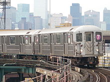
The Long Island Rail Road (LIRR) is North America's busiest commuter railroad system, carrying an average of 282,400 passengers each weekday on 728 daily trains. Chartered on April 24, 1834, and operating continuously since, it is also the oldest railroad in the U.S. that still operates under its original charter and name. The Metropolitan Transportation Authority has operated the LIRR as one of its two commuter railroads since 1966, and the LIRR is one of the few railroads worldwide that provides service all the time, year round.[125][126] In July 2017, a $2 billion plan to add a third railroad track to the LIRR Main Line between the Floral Park and Hicksville stations in Nassau County was approved.[127] Other LIRR projects, such as the Ronkonkoma Branch Double Track Project, are also underway.[128][129] Five "readiness projects" across the LIRR system, which will cost a combined $495 million, are also under construction in preparation for expanded peak-hour LIRR service after the completion of East Side Access, which will bring LIRR trains to Grand Central Terminal.[130][131][132]
Bus[]

Nassau Inter-County Express (NICE) provides bus service in Nassau County, while Suffolk County Transit, an agency of the Suffolk County government, provides bus service in Suffolk County. In 2012, NICE replaced the former MTA Long Island Bus in transporting Long Islanders across Nassau County while allowing them to use MTA MetroCards as payment.[133]
Roads[]

The Long Island Expressway, Northern State Parkway, and Southern State Parkway, all products of the automobile-centered planning of Robert Moses, are the island's primary east–west high-speed controlled-access highways.
| Direction | Route shield |
Name |
|---|---|---|
| West-East | Nassau Expressway northern section | |
| Montauk Highway | ||
| Sunrise Highway* | ||
| Belt Parkway / Southern State Parkway | ||
| Hempstead Turnpike | ||
| Babylon–Farmingdale Turnpike | ||
| Grand Central Parkway / Northern State Parkway | ||
| Long Island Expressway | ||
| Jericho Turnpike/Middle Country Road | ||
| Northern Boulevard | ||
| South-North | Brooklyn-Queens Expressway | |
| Van Wyck Expressway | ||
| Nassau Expressway southern section | ||
| Clearview Expressway | ||
| Cross Island Parkway | ||
| Meadowbrook State Parkway | ||
| Wantagh State Parkway | ||
| Newbridge Road | ||
| Cedar Swamp Road/Broadway/Hicksville Road | ||
| Seaford-Oyster Bay Expressway | ||
| Broad Hollow Road | ||
| Deer Park Avenue | ||
| Robert Moses Causeway | ||
| Sagtikos State Parkway | ||
| Sunken Meadow State Parkway | ||
| Islip Avenue | ||
| Nicolls Road | ||
| William Floyd Parkway | ||
|
Roads in boldface are limited access roads. | ||
Ground transportation[]
Several hundred transportation companies service the Long Island/New York City area. Winston Airport Shuttle, the oldest of these companies in business since 1973, was the first to introduce door-to-door shared-ride service to and from the major airports, which almost all transportation companies now use.[134]
See also[]
- List of tallest buildings on Long Island
- Geography of New York City
- List of films shot on Long Island
- List of Long Island recreational facilities
- List of Long Islanders, famous residents of Nassau and Suffolk
- List of people from New York City, including famous residents of Brooklyn and Queens
- Long Island (proposed state)
- Timeline of town creation in Downstate New York
Notes[]
- ^ Mean monthly maxima and minima (i.e. the expected highest and lowest temperature readings at any point during the year or given month) calculated based on data at said location from 1991 to 2020.
- ^ Jump up to: a b Mean monthly maxima and minima (i.e. the expected highest and lowest temperature readings at any point during the year or given month) calculated based on data at said location from 1991 to 2020.
References[]
- ^ Richmond Hill Historic Society Archived May 15, 2013, at the Wayback Machine Tributary tribes
- ^ Jump up to: a b Annie Correal (August 12, 2021). "New York City adds 629,000 people, defying predictions of its decline". The New York Times. Retrieved August 14, 2021.
- ^ "About Long Island". LongIsland.com. Archived from the original on May 16, 2015. Retrieved December 26, 2012.
Many people in the New York metropolitan area (even those on the island in Queens and Brooklyn) use the term "Long Island" or "the island" to refer to the more suburban Nassau and Suffolk counties only.
- ^ Jen Carlson (May 21, 2012). "Do You Refer To Manhattan As "The City"?". Gothamist. Archived from the original on October 25, 2016. Retrieved July 13, 2017.
- ^ Long Island Official Website of New York State. Retrieved 2021-03-04.
- ^ John Burbidge (November 21, 2004). "Long Island at its Best; Who's the Longest of Them All?". The New York Times. Archived from the original on April 30, 2011. Retrieved April 30, 2011.
But the court wasn't saying Long Island isn't an island in a geographical sense", he continued. "In fact, all parties involved in the case agreed Long Island is a geographical island. It was only for the purposes of the case that the island was declared an extension of New York's coastline.
- ^ "Long Island". Encyclopædia Britannica (Britannica Concise ed.). Encyclopædia Britannica, Inc. 2011. 9370515. Archived from the original on November 5, 2007. Retrieved April 30, 2011.
- ^ "Secretary of State of Rhode Island". Archived from the original on January 1, 2016. Retrieved April 30, 2011.
This total excludes U.S. territorial waters, which were included in previous years.
- ^ "Annual Estimates of the Resident Population: April 1, 2010 to July 1, 2015 - 2015 Population Estimates". United States Census Bureau. Archived from the original on May 15, 2016. Retrieved March 24, 2016.
- ^ "Kings County, New York QuickFacts". U.S. Census Bureau. Archived from the original on February 17, 2016. Retrieved March 24, 2016.
- ^ "Queens County, New York QuickFacts". U.S. Census Bureau. Archived from the original on August 8, 2014. Retrieved March 24, 2016.
- ^ "Nassau County, New York QuickFacts". U.S. Census Bureau. Archived from the original on June 7, 2011. Retrieved March 24, 2016.
- ^ "Suffolk County, New York QuickFacts". U.S. Census Bureau. Archived from the original on June 24, 2011. Retrieved March 24, 2016.
- ^ "Transit Ridership Report Fourth Quarter and End-of-Year 2014" (PDF). American Public Transportation Association (APTA). March 3, 2015. Archived from the original (PDF) on October 11, 2017. Retrieved October 28, 2016.
- ^ "Student Science a Resource of Society for Science & the Public". Society for Science & the Public. Archived from the original on November 27, 2015. Retrieved March 23, 2019.
- ^ [1] Archived November 16, 2016, at the Wayback Machine Accessed November 16, 2016.
- ^ Jump up to: a b "Long Island Indians and The Early Settlers". longislandgenealogy.com. Archived from the original on March 29, 2013. Retrieved November 7, 2019.
- ^ Jump up to: a b "Long Island Indian Tribes- Richmond Hill Historical Society". www.richmondhillhistory.org. Archived from the original on October 28, 2019. Retrieved November 7, 2019.
- ^ "Hudson Valley's Tribal History". www.westchestermagazine.com. Archived from the original on November 7, 2019. Retrieved November 7, 2019.
- ^ "The Tribes of Long Island". On This Site. Archived from the original on November 7, 2019. Retrieved November 7, 2019.
- ^ "Lenni Lenape Culture | Native American Netroots". Archived from the original on November 19, 2019. Retrieved November 7, 2019.
- ^ "Our Tribal History..." nanticoke-lenape.info. Archived from the original on June 10, 2019. Retrieved November 7, 2019.
- ^ Weigold, Marilyn E. (August 2004). The Long Island Sound: A History of Its People, Places, and Environment. NYU Press. ISBN 9780814794005. Archived from the original on August 5, 2020. Retrieved November 7, 2019.
- ^ Edwin, Burrows; Wallace, Mike (1999). "Lenape" (PDF). Archived (PDF) from the original on November 1, 2020. Retrieved April 8, 2020. Cite journal requires
|journal=(help) - ^ Jump up to: a b Tooker, William Wallace (1911). The Indian Place-Names On Long Island and Islands Adjacent With Their Probable Significations. pp. 35, 212, 232–233.
- ^ "The Dutch Period, with maps and explanatory text". Archived from the original on January 31, 2013. Retrieved October 15, 2012.
- ^ "Close-up of 1650s map". Archived from the original on January 6, 2013. Retrieved October 15, 2012.
- ^ "Last will and testament of Thomas Powell Sen late of Bethpage now of Westbury in the limits of Hempstead in Queens County on Nassau Island in the Colony of New York". 1719–1720. Archived from the original on May 15, 2013. Retrieved October 15, 2012.
- ^ "Early Indian Life on Long Island". Richmond Hill Historical Society website. Richmond Hill Historical Society. Archived from the original on May 15, 2013. Retrieved March 22, 2013.
- ^ Nenner 2004.
- ^ Bayles, Richard Mather (1874). Sketches of Suffolk County, Historical and Descriptive, with a Historical Outline of Long Island. The Author.
- ^ "Of Interest to Politicians". The New York Times. September 13, 1894. p. 9. Archived from the original on June 14, 2018. Retrieved April 30, 2011.
The question of the Greater New-York, which is also to be submitted to the people at this coming election, involves the proposition to unite in one city the following cities, counties, and towns: New-York City, Long Island City, in Queens County; the County of Kings, (Brooklyn;) the County of Richmond, (S.I.;) the towns of Flushing, Newtown, Jamaica, in Queens County; the town of Westchester, in Westchester County, and all that portion of the towns of East Chester and Pelham which lies south of a straight line drawn from a point where the northerly line of the City of New-York meets the centre line of the Bronx River, to the middle of the channel between Hunter's and Glen Islands, in Long Island Sound, and that part of the town of Hempstead, in Queens County, which is westerly of a straight line drawn from the south-easterly point of the town of Flushing in a straight line to the Atlantic Ocean.
(before vote) - ^ "Vote for Greater New York". The New York Times. October 16, 1894. Archived from the original on January 17, 2012. Retrieved April 30, 2011. (before election)
- ^ "New-York's Place in Danger; Consolidation Defeated, She Must Yield, to Chicago". The New York Times. November 4, 1894. Archived from the original on June 14, 2018. Retrieved April 30, 2011. (before election)
- ^ "Greater New-York in Doubt: The City Vote is for it and Brooklyn is uncertain". NY Times. November 8, 1894. Archived from the original on June 14, 2018. Retrieved April 30, 2011.
The increase in area and population that New-York will acquire if consolidation becomes a fact will become evident by a glance at the following table... Flushing... * Part of the town of Hempstead... Jamaica... Long Island City ... Newtown... The townships in Queens County that are to be included in the Greater New-York have not been heard from yet...
(before results of Queens vote known) - ^ "Report Favors Consolidation; An Argument Against the Claims of the Resubmissionists". The New York Times. February 22, 1896. p. 1. Archived from the original on June 14, 2018. Retrieved April 30, 2011.
- ^ "The East City Line Fixed". The New York Times. February 12, 1899. p. 15. Archived from the original on June 14, 2018. Retrieved April 30, 2011.
- ^ Wierzyński, Kazimierz (1966). Moja prywatna Ameryka (first ed.). Londyn: Polska Fundacja Kulturalna. p. 14.
- ^ "Long Island (Nassau-Suffolk Metro Division)". Federal Reserve Bank of New York. August 2011. Archived from the original on October 13, 2012. Retrieved June 24, 2012.
- ^ "The Real Estate Field – On Long Island" (PDF). The New York Times. December 11, 1911. Archived (PDF) from the original on September 16, 2018. Retrieved April 30, 2011.
- ^ "UNITED STATES v. MAINE et al. (Rhode Island and New York Boundary Case)". LII / Legal Information Institute. Retrieved June 8, 2021.
- ^ "LONG ISLAND AT ITS BEST; Who's the Longest of Them All?". Archived from the original on July 30, 2017. Retrieved November 1, 2020.
- ^ "LONG ISLAND OPINION; LONG PENINSULA: THE SHAPE OF THINGS TO COME". Archived from the original on April 4, 2017. Retrieved February 10, 2017.
- ^ Long Island Peninsula: Could Have Had Far-Reaching Effects Archived April 30, 2012, at the Wayback Machine
- ^ Piniat, Elaine (February 20, 2016). "True or false? Long Island is an island". Newsday. Archived from the original on January 19, 2019. Retrieved January 18, 2019.
- ^ "Long Island Wine Country – The Official Website Of The Long Island Wine Council". The Long Island Wine Council. Archived from the original on April 21, 2015. Retrieved April 25, 2015.
- ^ Bennington, J Bret (2003). "New observations on the glacial geomorphology of long island from a digital elevation model (DEM)" (PDF). Hofstra University. Archived (PDF) from the original on January 13, 2016. Retrieved January 25, 2016.
- ^ DeWan, George. "Long Island History: The Prairie That Was". Newsday.com. Archived from the original on April 15, 2008. Retrieved January 4, 2009.
- ^ Henry Goldman (October 30, 2018). "NYC's Fastest-Growing Neighborhood Gets $180 Million Investment". Bloomberg, L.P. Archived from the original on October 31, 2018. Retrieved November 13, 2018.
- ^ Peel, M. C. and Finlayson, B. L. and McMahon, T. A. (2007). "Updated world map of the Köppen–Geiger climate classification". Hydrol. Earth Syst. Sci. 11 (5): 1633–1644. doi:10.5194/hess-11-1633-2007. ISSN 1027-5606. Archived from the original on February 10, 2017. Retrieved March 19, 2014.CS1 maint: multiple names: authors list (link) (direct: Final Revised Paper Archived February 29, 2012, at the Wayback Machine)
- ^ "united states annual sunshine map". HowStuffWorks, Inc. Archived from the original on April 29, 2011. Retrieved April 30, 2011.
- ^ "NowData – NOAA Online Weather Data". National Oceanic and Atmospheric Administration. Archived from the original on May 27, 2015. Retrieved February 28, 2014.
- ^ "Storm Events Database". NOAA National Centers for Environmental Information. Archived from the original on August 28, 2016. Retrieved August 26, 2016.
- ^ "Vulnerable Cities: Long Island". weather.com. The Weather Channel. Archived from the original on April 10, 2006. Retrieved April 30, 2011.
- ^ "Irene Makes NYC Landfall as Tropical Storm With Rain, Flooding". Bloomberg Business Week. August 28, 2011. Archived from the original on December 9, 2012. Retrieved November 8, 2012.
- ^ "Superstorm Sandy Sparks Floods, Blackouts on Long Island". Long Island Press. October 30, 2012. Archived from the original on November 4, 2012. Retrieved November 8, 2012.
- ^ "Comptroller: Sandy cost estimate may hit $18 billion". Newsday. November 2, 2012. Archived from the original on November 8, 2012. Retrieved November 8, 2012.
- ^ "Superstorm Sandy Breaks Records". CNN.com. October 30, 2012. Archived from the original on November 3, 2012. Retrieved November 8, 2012.
- ^ "Archived copy". Archived from the original on July 9, 2014. Retrieved September 6, 2014.CS1 maint: archived copy as title (link)[full citation needed]
- ^ Jeff Stone & Maria Gallucci (October 29, 2014). "Hurricane Sandy Anniversary 2014: Fortifying New York -- How Well Armored Are We For The Next Superstorm?". International Business Times. Archived from the original on July 24, 2015. Retrieved July 23, 2015.
- ^ Robert S. Eshelman (November 15, 2012). "ADAPTATION: Political support for a sea wall in New York Harbor begins to form". E&E Publishing, LLC. Archived from the original on February 5, 2013. Retrieved July 23, 2015.
- ^ "NowData – NOAA Online Weather Data". National Oceanic and Atmospheric Administration. Retrieved August 9, 2021.
- ^ "Station: Islip LI MacArthur AP, NY". U.S. Climate Normals 2020: U.S. Monthly Climate Normals (1991-2020). National Oceanic and Atmospheric Administration. Retrieved August 9, 2021.
- ^ Jump up to: a b "NowData - NOAA Online Weather Data". National Oceanic and Atmospheric Administration. Retrieved May 9, 2021.
- ^ "Station: New York LaGuardia AP, NY". U.S. Climate Normals 2020: U.S. Monthly Climate Normals (1991-2020). National Oceanic and Atmospheric Administration. Retrieved May 9, 2021.
- ^ "NEW YORK/LAGUARDIA ARPT NY Climate Normals 1961−1990". NOAA. Retrieved March 23, 2014.
- ^ "Station: New York JFK INTL AP, NY". U.S. Climate Normals 2020: U.S. Monthly Climate Normals (1991-2020). National Oceanic and Atmospheric Administration. Retrieved May 9, 2021.
- ^ "NEW YORK/JFK, NY Climate Normals 1961−1990". NOAA. Retrieved March 23, 2014.
- ^ "Station Name: NY MONTAUK AP". ftp.ncdc.noaa.gov. National Oceanic and Atmospheric Administration. Retrieved June 27, 2013.
- ^ Liz Robbins (April 15, 2015). "Influx of Chinese Immigrants Is Reshaping Large Parts of Brooklyn". The New York Times. Archived from the original on April 16, 2015. Retrieved April 15, 2015.
- ^ Jump up to: a b [2] Archived February 15, 2020, at archive.today Accessed September 3, 2017.
- ^ "Yearbook of Immigration Statistics: 2013 Supplemental Table 2". U.S. Department of Homeland Security. Archived from the original on May 1, 2015. Retrieved August 12, 2017.
- ^ "Yearbook of Immigration Statistics: 2012 Supplemental Table 2". U.S. Department of Homeland Security. Archived from the original on December 22, 2014. Retrieved August 12, 2017.
- ^ "Yearbook of Immigration Statistics: 2013 Supplemental Table 1". U.S. Department of Homeland Security. Archived from the original on July 7, 2017. Retrieved August 12, 2017.
- ^ "Yearbook of Immigration Statistics: 2012 Supplemental Table 1". U.S. Department of Homeland Security. Archived from the original on July 7, 2017. Retrieved August 12, 2017.
- ^ Vivian Yee (February 22, 2015). "Indictment of New York Officer Divides Chinese-Americans". The New York Times. Archived from the original on February 24, 2015. Retrieved August 12, 2017.
- ^ "Chinese New Year 2012 in Flushing". QueensBuzz.com. January 25, 2012. Archived from the original on May 26, 2013. Retrieved August 12, 2017.
- ^ "QuickFacts New York". United States Census Bureau. Archived from the original on September 18, 2015. Retrieved March 24, 2016.
- ^ Levy, Francesca (March 1, 2010). "americas-richest-counties: Personal Finance News from Yahoo! Finance". Finance.yahoo.com. Archived from the original on November 6, 2011. Retrieved January 2, 2012.
- ^ 2010 Census Data. "U.S. Census Bureau Census 2010". 2010.census.gov. Archived from the original on February 15, 2012. Retrieved January 2, 2012.
- ^ Lambert, Bruce (June 5, 2002). "Study Calls L.I. Most Segregated Suburb". The New York Times. Archived from the original on May 16, 2013. Retrieved April 30, 2011.
- ^ Christine Kim; Demand Media. "Queens, New York, Sightseeing". USA TODAY. Archived from the original on June 16, 2016. Retrieved June 23, 2014.
- ^ Andrew Weber (April 30, 2013). "Queens". NewYork.com. Archived from the original on May 13, 2015. Retrieved May 12, 2015.
- ^ Jump up to: a b "The Association of Religion Data Archives (ARDA), Year 2000 Report". Archived from the original on January 16, 2009. Retrieved March 20, 2007. Churches were asked for their membership numbers. ARDA estimates that most of the churches not reporting were black Protestant congregations.
- ^ Heng Shao (April 10, 2014). "Join The Great Gatsby: Chinese Real Estate Buyers Fan Out To Long Island's North Shore". Forbes. Archived from the original on August 8, 2014. Retrieved August 2, 2014.
- ^ Lawrence A. McGlinn, Department of Geography SUNY-New Paltz (2002). "BEYOND CHINATOWN: DUAL IMMIGRATION AND THE CHINESE POPULATION OF METROPOLITAN NEW YORK CITY, 2000" (PDF). Journal of the Middle States Division of the Association of American Geographers. Middle States Geographer. 35: 110–119. Archived from the original (PDF) on October 29, 2012. Retrieved June 25, 2012.
- ^ Jump up to: a b c Carol Hymowitz (October 27, 2014). "One Percenters Drop Six Figures at Long Island Mall". Bloomberg L.P. Archived from the original on October 29, 2014. Retrieved October 29, 2014.
- ^ Haller, Vera (October 1, 2014). "Downtown Flushing: Where Asian Cultures Thrive". The New York Times. Archived from the original on March 28, 2019. Retrieved March 23, 2019.
- ^ Max Falkowitz (August 25, 2018). "A World of Food, Outside the U.S. Open Gates". The New York Times. Archived from the original on March 28, 2019. Retrieved March 23, 2019.
- ^ Melia Robinson (May 27, 2015). "This is what it's like in one of the biggest and fastest growing Chinatowns in the world". Business Insider. Archived from the original on July 30, 2017. Retrieved March 19, 2019.
- ^ Nicholas Kulish, Frances Robles, and Patricia Mazzei (March 2, 2019). "Behind Illicit Massage Parlors Lie a Vast Crime Network and Modern Indentured Servitude". The New York Times. Archived from the original on March 6, 2019. Retrieved March 2, 2019.CS1 maint: multiple names: authors list (link)
- ^ Sarah Ngu (January 29, 2021). "'Not what it used to be': in New York, Flushing's Asian residents brace against gentrification". The Guardian US. Retrieved August 13, 2020.
The three developers have stressed in public hearings that they are not outsiders to Flushing, which is 69% Asian. 'They’ve been here, they live here, they work here, they’ve invested here,' said Ross Moskowitz, an attorney for the developers at a different public hearing in February...Tangram Tower, a luxury mixed-use development built by F&T. Last year, prices for two-bedroom apartments started at $1.15m...The influx of transnational capital and rise of luxury developments in Flushing has displaced longtime immigrant residents and small business owners, as well as disrupted its cultural and culinary landscape. These changes follow the familiar script of gentrification, but with a change of actors: it is Chinese American developers and wealthy Chinese immigrants who are gentrifying this working-class neighborhood, which is majority Chinese.
- ^ Alan Krawitz. "Hicksville: LI's LITTLE INDIA". Newsday. Retrieved February 13, 2020.
- ^ Heng Shao (April 10, 2014). "Join The Great Gatsby: Chinese Real Estate Buyers Fan Out To Long Island's North Shore". Forbes. Retrieved August 2, 2014.
- ^ Lawrence A. McGlinn, Department of Geography SUNY-New Paltz (2002). "BEYOND CHINATOWN: DUAL IMMIGRATION AND THE CHINESE POPULATION OF METROPOLITAN NEW YORK CITY, 2000" (PDF). Journal of the Middle States Division of the Association of American Geographers. Middle States Geographer. 35: 110–119. Archived from the original (PDF) on October 29, 2012. Retrieved April 7, 2016.
- ^ [3]
- ^ Asian Americans: Contemporary Trends and Issues Second Edition, Edited by Pyong Gap Min. Pine Forge Press – An Imprint of Sage Publications, Inc. 2006. ISBN 9781412905565. Retrieved January 10, 2013.
- ^ Jump up to: a b Kirk Semple (June 8, 2013). "City's Newest Immigrant Enclaves, From Little Guyana to Meokjagolmok". The New York Times. Archived from the original on September 4, 2015. Retrieved June 9, 2013.
- ^ Jump up to: a b John Roleke. "Flushing: Queens Neighborhood Profile". About.com. Archived from the original on April 30, 2013. Retrieved June 9, 2013.
- ^ "Koreatown Manhattan, or Koreatown Flushing?". CBS Interactive Inc. June 2009. Archived from the original on October 17, 2013. Retrieved June 9, 2013.
- ^ Joyce Cohen (March 23, 2003). "If You're Thinking of Living In/Murray Hill, Queens; The Name's the Same, the Pace is Slower". The New York Times. Archived from the original on May 16, 2013. Retrieved June 9, 2013.
- ^ Semple, Kirk (November 17, 2010). "Long Island Study Rebuts Views on Immigrant Workers". The New York Times. Archived from the original on December 30, 2011. Retrieved January 14, 2013.
- ^ Raisa Bruner (March 7, 2016). "The 25 most expensive ZIP codes in America". Business Insider. Archived from the original on March 8, 2016. Retrieved March 9, 2016.
- ^ "All New York City Council Members". New York City Council. The City of New York. Archived from the original on August 7, 2016. Retrieved August 8, 2016.
- ^ Michael J. Trinklein (April 2, 2010). "Beyond 50: American States That Might Have Been". National Public Radio. Archived from the original on December 23, 2010. Retrieved April 30, 2011.
- ^ "Secession Dreaming". Staten Island Advance Editorial. May 17, 2009. Archived from the original on June 15, 2011. Retrieved April 30, 2011.
- ^ "Lindsay and Sawicki Renew Push for a State of Long Island" (PDF) (Press release). February 1, 2010. Archived from the original (PDF) on March 4, 2016. Retrieved July 7, 2014.
- ^ Casesse, Sid and William Murphy (May 1, 2010). Nassau Executive Magnano Supports Long Island as 51st State Archived July 28, 2017, at the Wayback Machine. Newsday. Retrieved May 1, 2010.
- ^ "Education: New York High Schools". U.S. News & World Report. Archived from the original on August 14, 2017. Retrieved September 4, 2017.
- ^ "Best Private High Schools in America". Niche. Archived from the original on July 29, 2016.
- ^ Jacobson, Mark. "L.I.R.R. (Long Island Rock 'n' Roll)". NYMag.com. Archived from the original on January 10, 2019. Retrieved January 9, 2019.
- ^ "Jones Beach Amphitheater". Archived from the original on June 1, 2012. Retrieved April 30, 2011.
- ^ "About the SCMEA". Archived from the original on July 5, 2013. Retrieved April 30, 2011.
- ^ "NYSSMA Zone Map". Archived from the original on July 23, 2011. Retrieved April 30, 2011.
- ^ "Edible Long Island". October 8, 2008. Archived from the original on November 1, 2020. Retrieved July 23, 2014.
- ^ "Long Island's Ducks are Still Table Favorites". New York Times. December 21, 2003. Archived from the original on August 8, 2014. Retrieved July 23, 2014.
- ^ "In Riverhead, Where the Buffalo Roam". New York Times. July 18, 1999. Archived from the original on August 8, 2014. Retrieved July 23, 2014.
- ^ "Can Long Island Make World-Class Wines?". November 2007. Archived from the original on July 29, 2014. Retrieved July 23, 2014.
- ^ "Number of LI craft brewers have tripled in recent years". May 2, 2013. Archived from the original on August 11, 2014. Retrieved July 23, 2014.
- ^ "Here's the Long Island Iced Tea's High-Proof Origin Story". February 22, 2013. Archived from the original on July 29, 2014. Retrieved July 23, 2014.
- ^ Jump up to: a b Peter M. Gianotti, Melissa McCart, and Erica Marcus (March 24, 2017). "The best Asian restaurants on Long Island: Eat here now". Newsday. Archived from the original on August 1, 2017. Retrieved July 21, 2017.CS1 maint: multiple names: authors list (link)
- ^ Jump up to: a b "Latin American restaurants on Long Island: Our critics' favorites". Newsday. November 12, 2015. Archived from the original on September 14, 2017. Retrieved July 21, 2017.
- ^ "Transportation Network". Metropolitan Transportation Authority. February 11, 2018. Archived from the original on February 11, 2018. Retrieved February 11, 2018.
- ^ "MTA – About Bridges & Tunnels". Archived from the original on September 11, 2017. Retrieved October 1, 2014.
- ^ "The MTA Network". Archived from the original on April 3, 2014. Retrieved April 30, 2011.
- ^ "LIRR History". Metropolitan Transportation Authority (MTA). Archived from the original on March 4, 2016. Retrieved March 7, 2016.
- ^ Sophia Hall (July 12, 2017). "New York Senate Republicans OK $1.9B In Funding For 3rd LIRR Track". CBS New York. Archived from the original on July 12, 2017. Retrieved July 15, 2017.
- ^ "LIRR's double-track project nears completion". Progressive Railroading. April 30, 2018. Archived from the original on May 19, 2018. Retrieved May 18, 2018.
- ^ "LIRR schedules change as track work nears completion". Metro US. April 27, 2018. Archived from the original on May 19, 2018. Retrieved May 18, 2018.
- ^ Anuta, Joe; Newman, Philip (June 5, 2013). "Queens Tomorrow: LIRR headed to Grand Central". TimesLedger. TimesLedger Newspapers. Archived from the original on May 25, 2018. Retrieved May 24, 2018.
- ^ "MTA Capital Program Oversight Meeting" (PDF). mta.info. Metropolitan Transportation Authority. January 2013. p. 8. Archived (PDF) from the original on October 25, 2017. Retrieved May 24, 2018.
- ^ "MTA Long Island Rail Road Committee Meeting" (PDF). mta.info. Metropolitan Transportation Authority. November 2017. p. 35. Archived (PDF) from the original on February 5, 2018. Retrieved May 24, 2018.
- ^ Bolger, Timothy. (December 30, 2011) NICE Bus Replacing Long Island Bus This Weekend | Long Island Press Archived June 23, 2013, at the Wayback Machine. Archive.longislandpress.com. Retrieved on July 21, 2013.
- ^ "About GO Winston". Archived from the original on September 12, 2014. Retrieved September 13, 2014.
External links[]
 Media related to Long Island at Wikimedia Commons
 Long Island travel guide from Wikivoyage
- Ripley, George; Dana, Charles A., eds. (1879). . The American Cyclopædia.
| show Places adjacent to Long Island |
|---|


| show Authority control |
|---|
- Long Island
- Islands of New York (state)
- Coastal islands of New York (state)
- Moraines of the United States
- New York metropolitan area
- Islands of New York City
- Landforms of Long Island