Cove Neck, New York
Cove Neck, New York | |
|---|---|
Village | |
| Incorporated Village of Cove Neck | |
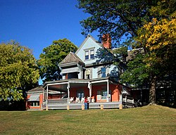 Sagamore Hill, Cove Neck's best-known landmark. | |
 Location in Nassau County and the state of New York. | |
 Cove Neck, New York Location within the state of New York | |
| Coordinates: 40°52′40″N 73°29′50″W / 40.87778°N 73.49722°WCoordinates: 40°52′40″N 73°29′50″W / 40.87778°N 73.49722°W | |
| Country | |
| State | |
| County | |
| Town | Oyster Bay |
| Incorporated | 1927 |
| Government | |
| • Mayor | Thomas R. Zoller |
| • Deputy Mayor | Lisabeth Harris |
| Area | |
| • Total | 1.56 sq mi (4.05 km2) |
| • Land | 1.28 sq mi (3.33 km2) |
| • Water | 0.28 sq mi (0.72 km2) |
| Elevation | 23 ft (7 m) |
| Population (2010) | |
| • Total | 286 |
| • Estimate (2019)[2] | 301 |
| • Density | 234.42/sq mi (90.50/km2) |
| Time zone | UTC-5 (Eastern (EST)) |
| • Summer (DST) | UTC-4 (EDT) |
| ZIP code | 11771 |
| Area code(s) | 516 |
| FIPS code | 36-18597 |
| GNIS feature ID | 0947571 |
| Website | www |

Cove Neck is a village located within the Town of Oyster Bay in Nassau County, on the North Shore of Long Island, in New York, United States. The population was 286 at the 2010 census.[3]
History[]
Cove Neck incorporated as a village in 1927.[4]
Cove Neck is the site of the home of President Theodore Roosevelt.[5][6] His estate, Sagamore Hill, is now a museum operated by the National Park Service.[5] It attracts many visitors annually.[5]
On January 25, 1990, Avianca Flight 52, a Boeing 707, ran out of fuel before crashing into a hillside in Cove Neck.[6][7][8] 73 out of the 158 passengers and crew onboard died in the accident.[8]
Geography[]
According to the United States Census Bureau, the village has a total area of 1.6 square miles (4.1 km2), of which 1.3 square miles (3.4 km2) is land and 0.3 square miles (0.78 km2), or 18.47%, is water.[9]
The village is located on a peninsula projecting into Oyster Bay.[10] It is located directly across from Centre Island.[10]
Demographics[]
| Historical population | |||
|---|---|---|---|
| Census | Pop. | %± | |
| 1930 | 276 | — | |
| 1940 | 130 | −52.9% | |
| 1950 | 200 | 53.8% | |
| 1960 | 299 | 49.5% | |
| 1970 | 344 | 15.1% | |
| 1980 | 331 | −3.8% | |
| 1990 | 332 | 0.3% | |
| 2000 | 300 | −9.6% | |
| 2010 | 286 | −4.7% | |
| 2019 (est.) | 301 | [2] | 5.2% |
| U.S. Decennial Census[11] | |||
As of the census[12] of 2000, there were 300 people, 110 households, and 83 families in the village. The population density was 233.4 people per square mile (89.8/km2). There were 140 housing units at an average density of 108.9 per square mile (41.9/km2). es living together, 7.3% had a female householder with no husband present, and 24.5% were non-families. 19.1% of households were one person and 11.8% were one person aged 65 or older. The average household size was 2.73 and the average family size was 3.16.
The age distribution was 26.3% under the age of 18, 4.7% from 18 to 24, 20.3% from 25 to 44, 29.3% from 45 to 64, and 19.3% 65 or older. The median age was 44 years. For every 100 females, there were 96.1 males. For every 100 females age 18 and over, there were 87.3 males.
Government[]
As of December 2021, the Mayor of Cove Neck is Thomas R. Zoller, the Deputy Mayor is Lisabeth Harris, and the Village Trustees are Joseph Castellano, Lisabeth Harris, Marjorie Isaksen, and Marta Kelly.[13]
Politics[]
In the 2016 U.S. presidential election, the majority of Cove Neck voters voted for Hillary Clinton (D).[14]
Education[]
The entirety of Cove Neck is located within the boundaries of (and is thus served by) the Oyster Bay-East Norwich Central School District.[10][15] As such, all children who reside within the village and attend public schools go to Oyster Bay–East Norwich's schools.[10]
Notable people[]
- John McEnroe – Tennis player.[6]
- Theodore Roosevelt – 26th President of the United States.[5]
- Charles Wang – Businessman and former owner of the New York Islanders.[6]
References[]
- ^ "2019 U.S. Gazetteer Files". United States Census Bureau. Retrieved July 27, 2020.
- ^ a b "Population and Housing Unit Estimates". United States Census Bureau. May 24, 2020. Retrieved May 27, 2020.
- ^ "Race, Hispanic or Latino, Age, and Housing Occupancy: 2010 Census Redistricting Data (Public Law 94-171) Summary File (QT-PL), Cove Neck village, New York". United States Census Bureau. Retrieved October 3, 2011.
- ^ Winsche, Richard (October 1, 1999). The History of Nassau County Community Place-Names. Interlaken, New York: Empire State Books. ISBN 978-1557871541.
- ^ a b c d "Sagamore Hill". www.coveneck.org. Retrieved 2021-12-20.
- ^ a b c d "Long Island History: Cove Neck". 2005-08-11. Archived from the original on 11 August 2005. Retrieved 2021-12-20.
- ^ Ranter, Harro. "Aviation Safety Network > Accident investigation > CVR / FDR > Transcripts > CVR transcript Avianca Flight 052 - 25 JAN 1990". aviation-safety.net. Retrieved 2021-12-20.
- ^ a b Navarro, Mireya (1990-06-25). "For Some, No Escape From L.I. Jet Crash". The New York Times. ISSN 0362-4331. Retrieved 2021-12-20.
- ^ "US Gazetteer files: 2010, 2000, and 1990". United States Census Bureau. 2011-02-12. Retrieved 2011-04-23.
- ^ a b c d "Long Island Index: Interactive Map". www.longislandindexmaps.org. Retrieved 2021-12-20.
- ^ "Census of Population and Housing". Census.gov. Retrieved June 4, 2015.
- ^ "U.S. Census website". United States Census Bureau. Retrieved 2008-01-31.
- ^ "Village Officials". www.coveneck.org. Retrieved 2021-12-20.
- ^ Welch, Will (2017-11-08). "How Long Island Voted". Newsday. Retrieved 2021-12-20.
- ^ "Composite School District Boundaries Shapefiles". NCES. Retrieved 2020-10-23.
External links[]
- Oyster Bay (town), New York
- Villages in New York (state)
- Long Island Sound
- Villages in Nassau County, New York
- Populated coastal places in New York (state)
- Sundown towns in New York (state)