Muttontown, New York
Muttontown, New York | |
|---|---|
Village | |
| Incorporated Village of Muttontown | |
 Muttontown Village Hall. | |
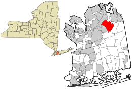 Location in Nassau County and the state of New York. | |
 Muttontown, New York Location within the state of New York | |
| Coordinates: 40°49′20″N 73°31′37″W / 40.82222°N 73.52694°WCoordinates: 40°49′20″N 73°31′37″W / 40.82222°N 73.52694°W | |
| Country | |
| State | |
| County | |
| Town | Oyster Bay |
| Incorporated | 1931 |
| Government | |
| • Mayor | James Ligouri |
| Area | |
| • Total | 6.06 sq mi (15.69 km2) |
| • Land | 6.06 sq mi (15.69 km2) |
| • Water | 0.00 sq mi (0.00 km2) |
| Elevation | 285 ft (87 m) |
| Population (2010) | |
| • Total | 3,497 |
| • Estimate (2019)[2] | 3,668 |
| • Density | 605.58/sq mi (233.82/km2) |
| Time zone | UTC-5 (Eastern (EST)) |
| • Summer (DST) | UTC-4 (EDT) |
| Area code(s) | 516 |
| FIPS code | 36-49330 |
| GNIS feature ID | 0958224 |
| Website | www |


Muttontown is a village located within the Town of Oyster Bay in Nassau County, on Long Island, in New York, United States. The population was 3,497 at the 2010 census.
History[]
During colonial times, the area was used to raise sheep for wool and meat.[3] The village was incorporated in 1931.[3] The name of the village stems from its former use as pasturage for sheep.[3]
Zog of Albania bought the local Knollwood Estate in 1951, but sold it in 1955. The Benjamin Moore Estate was listed on the National Register of Historic Places in 1979.[4]
Muttontown was ranked one of the wealthiest towns in America by BusinessWeek.[5]
Geography[]

According to the United States Census Bureau, the village has a total area of 6.1 square miles (16 km2), all land.[6]
The village lost some territory between the 2000 and 2010 censuses to Syosset.[7]
Demographics[]
| Historical population | |||
|---|---|---|---|
| Census | Pop. | %± | |
| 1940 | 335 | — | |
| 1950 | 382 | 14.0% | |
| 1960 | 1,265 | 231.2% | |
| 1970 | 2,081 | 64.5% | |
| 1980 | 2,725 | 30.9% | |
| 1990 | 3,024 | 11.0% | |
| 2000 | 3,412 | 12.8% | |
| 2010 | 3,497 | 2.5% | |
| 2019 (est.) | 3,668 | [2] | 4.9% |
| U.S. Decennial Census[8] | |||
As of the census[9] of 2000, there were 3,412 people, 1,022 households, and 920 families residing in the village. The population density was 560.5 people per square mile (216.3/km2). There were 1,048 housing units at an average density of 172.1 per square mile (66.4/km2). The racial makeup of the village was 79.92% White, 1.82% African American, 16.00% Asian, 0.21% from other races, and 2.05% from two or more races. Hispanic and Latino of any race were 2.29% of the population.
There were 1,022 households, out of which 47.6% had children under the age of 18 living with them, 83.6% were married couples living together, 3.5% had a female householder with no husband present, and 9.9% were non-families. 7.4% of all households were made up of individuals, and 2.5% had someone living alone who was 65 years of age or older. The average household size was 3.34 and the average family size was 3.49.
In the village, the population was spread out, with 29.9% under the age of 18, 5.7% from 18 to 24, 23.4% from 25 to 44, 31.1% from 45 to 64, and 9.8% who were 65 years of age or older. The median age was 40 years. For every 100 females, there were 95.3 males. For every 100 females age 18 and over, there were 91.7 males.
The median income for a household in the village was $184,386, and the median income for a family was $190,358. Males had a median income of $100,000 versus $53,846 for females. The per capita income for the village was $88,020. About 2.0% of families and 3.4% of the population were below the poverty line, including 1.8% of those under age 18 and 4.5% of those age 65 or over.
Education[]
Muttontown is served by the Locust Valley Central School District, the Jericho Union Free School District, and the Syosset Central School District.[10] As such, students who attend public schools and reside in Muttontown attend school in one of these three districts depending on where they live in the village.[10]
Notable people[]
- Alicia Keys, singer/songwriter
- Al Trautwig, sports commentator
- Cliff Josephy, Professional Poker Player
- Lester L. Wolff, former member of the United States House of Representatives from New York
- Chad Pennington, football quarterback[11]
- Jose Reyes, infielder for the New York Mets
References[]
- ^ "2019 U.S. Gazetteer Files". United States Census Bureau. Retrieved July 27, 2020.
- ^ a b "Population and Housing Unit Estimates". United States Census Bureau. May 24, 2020. Retrieved May 27, 2020.
- ^ a b c Winsche, Richard (October 1, 1999). The History of Nassau County Community Place-Names. Interlaken, New York: Empire State Books. ISBN 978-1557871541.
- ^ "National Register Information System". National Register of Historic Places. National Park Service. March 13, 2009.
- ^ "The Wealthiest Towns in America: Muttontown, N.Y." p. 15. Part of: Gopal, Prashant (17 March 2009). "Where the Rich (Still) Live". Bloomberg Businessweek. Retrieved 29 December 2010.
- ^ "US Gazetteer files: 2010, 2000, and 1990". United States Census Bureau. 2011-02-12. Retrieved 2011-04-23.
- ^ "New York: 2010" (PDF). 2010. p. III-6. Retrieved 2021-10-01.
{{cite web}}: CS1 maint: url-status (link) - ^ "Census of Population and Housing". Census.gov. Retrieved June 4, 2015.
- ^ "U.S. Census website". United States Census Bureau. Retrieved 2008-01-31.
- ^ a b "Long Island Index: Interactive Map". www.longislandindexmaps.org. Retrieved 2021-08-09.
- ^ Woollard, Deidre. "Chad Pennington in Muttontown, Estate of the Day". Luxist. Retrieved 27 August 2011.
External links[]
- Villages in Nassau County, New York
- Oyster Bay (town), New York
- Villages in New York (state)