List of tallest buildings on Long Island

| Part of a series on |
| Long Island |
|---|
 |
| Topics |
|
| Regions |
|
Long Island is not known for having many tall buildings. As a suburban region, residents and local governments have generally opposed proposals to construct tall buildings, to distinguish it from neighboring Queens and Brooklyn, which geographically part of Long Island but are part of New York City. Most of the tallest buildings were constructed by government entities, who are exempt from local zoning regulations.
Long Island has one building taller than 300 feet (91 m), the Stony Brook University Hospital tower, and at least four other buildings taller than 200 feet, including Nassau University Medical Center and the Alfonse M. D'Amato United States Courthouse. Long Island has no cluster of high-rises dense enough to create an urban landscape, although there are regions with a larger number of scattered high-rises. A number of non-building structures are also prominent, such as the 620-foot (190 m) stacks of the Northport Power Station.
This article covers buildings in Nassau County and Suffolk County. Buildings in Queens and in Brooklyn are listed in their own articles, as the New York City boroughs are conventionally excluded from cultural definitions of Long Island.[1][2][3]
Overview[]
Long Island has few tall buildings, in contrast to neighboring New York City. Long Island's identity as the birthplace of suburbia involves a desire to maintain the opposite of an urban landscape, with a flat landscape where high-rises are seen to be eyesores that clash with their surroundings, and even three-story buildings can provoke opposition.[1][2] This has been characterized as a desire to prevent Long Island from being "Queensified", referring to the neighboring New York City borough.[2] The North Shore Towers complex of three 32-story apartment buildings, immediately over the border from Nassau County in Queens, has been often cited as the kind of development Long Islanders seek to avoid.[1][3][4]
It has been noted that since most buildings are lower than the trees, views from the few tall buildings consists almost of treetops punctuated by water towers.[1][4] The buildings themselves are generally regarded as being architecturally undistinguished.[1]
As of 1974, there were 107 municipal zoning codes on Long Island, most of which limited buildings to four stories;[4] in 2016 there were 175 zoning and building districts, stymieing the construction of tall buildings.[2] Most tall buildings on Long Island have been built by the state or county rather than private developers, as they are exempt from these local codes.[4] The opposition to high-rises also had a racial element, being stereotypically associated with minority residents.[1][2]
Patterns of development[]
While Long Island has no cluster of high-rises dense enough to create an urban landscape, there are regions with a larger number of scattered high-rises. One is the region in and around northern Uniondale in central Nassau County, including Hofstra University's library and six dormitory buildings, Nassau University Medical Center, Nassau Community College, four office buildings, and a hotel.[1][5] Another cluster of mid-rise apartment buildings is along the waterfront in Long Beach.[1]
A handful of tall buildings are part of former state psychiatric institutions scattered around Suffolk County, including Edgewood State Hospital (now demolished), Kings Park Psychiatric Center, and Pilgrim Psychiatric Center.[4]
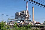
Long Island also has several non-building structures, including broadcast antennas, smokestacks, and water towers. The most prominent of these are the four 620-foot stacks of the Northport Power Station, and other power plants constructed by the Long Island Lighting Company.[1][4]
History[]
In the mid 20th century, Democrats generally favored more high-rises, while Republicans opposed them.[1][5] In the late 2000s, the Lighthouse Project proposal to construct a 60-story tower, later changed to two 30-story towers, near Nassau Coliseum was vigorously opposed.[6]
The 21st century saw the beginning of a movement in certain regions towards transit-oriented development around Long Island Rail Road stations, with 11,000 housing units approved in the nine years preceding 2016. The villages of Hempstead and Mineola were seen as being particularly receptive to taller residential buildings, along with Great Neck Plaza, Glen Cove, Long Beach, Farmingdale, Ronkonkoma, Riverhead, and Riverside.[2] On the other hand, the proposed Nassau Hub development surrounding Nassau Coliseum is envisioned as a "walkable, engaging suburban downtown" with no buildings over 100 feet.[7] Increasing the number of rental units, which are rare in the region, was seen as important to attracting young adults and thus employers, as well as retaining older residents who might otherwise relocate to Florida.[2]
Buildings[]
This list is incomplete; you can help by . (June 2021) |
This table lists buildings higher than 100 feet (30 m). A building is defined as a structure with walls and a roof.
| Name (Former names) |
Image | Height | Floors | Opened | Location | Notes | Coordinates | Refs |
|---|---|---|---|---|---|---|---|---|
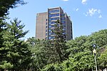
| Stony Brook University Hospital | 
|
360 ft 110 m |
16 | 1976 | Stony Brook | Tallest building in suburban Long Island, Suffolk County, and Town of Brookhaven | 40°54′35″N 73°06′57″W / 40.9097°N 73.1158°W | [1][4][8][9] |
| Nassau University Medical Center | 
|
299 ft 91 m |
19 | 1974 | East Meadow | Tallest building in Nassau County and Town of Hempstead | 40°43′34″N 73°33′18″W / 40.7261°N 73.5549°W | [1][4][5][10] |
| Alfonse M. D'Amato United States Courthouse | 
|
240 ft 73 m |
12 | 2000 | Central Islip | Tallest building in Town of Islip | 40°45′35″N 73°11′26″W / 40.7596°N 73.1906°W | [1][11] |
| Jones Beach Water Tower | 
|
231 ft 70 m |
N/A | 1929 | Jones Beach State Park | [4][12] | ||
| Edgewood State Hospital Building 102 | 229 ft 70 m |
13 | 1942 | Deer Park | Demolished; former tallest building in Town of Babylon | [4][13][14] | ||
| Robert Moses State Park Water Tower | 
|
208 ft 63 m |
N/A | 1968 | Robert Moses State Park | [4][15] | ||
| Hofstra University Constitution Hall |

|
184 ft 56 m |
15 | 1967 | Uniondale | [4][7] | ||
| Hofstra University Estabrook Hall |

|
184 ft 56 m |
15 | 1967 | Uniondale | [4][7] | ||
| Hofstra University Enterprise Hall |
|
184 ft 56 m |
15 | 1968 | Uniondale | [4][7] | ||
| Hofstra University Vander Poel Hall |

|
184 ft 56 m |
15 | 1968 | Uniondale | [4][7] | ||
| AT&T Site Tower | 176 ft 54 m |
11 | 1970 | Dix Hills | Tallest building in Town of Huntington | 40°42′44″N 73°43′20″W / 40.7122°N 73.7222°W | [4][16] | |
| RXR Plaza (EAB Plaza) |

|
175 ft 53 m |
15 | 1983 | Uniondale | Two towers of equal height | [1][8][7][17] | |
| H. Lee Dennison Administration Building | 
|
175 ft 53 m |
12 | 1969 | Hauppauge | [4][18][19] | ||
| Hofstra University Alliance Hall |

|
171 ft 52 m |
13 | 1966 | Uniondale | [4][7] | ||
| Hofstra University Bill of Rights Hall |

|
171 ft 52 m |
13 | 1966 | Uniondale | [4][7] | ||
| St. Agnes Cathedral | 
|
168 ft 51 m |
N/A | 1935 | Rockville Centre | 40°39′35″N 73°38′47″W / 40.6598°N 73.6463°W | [4][20] | |
| Cathedral of the Incarnation | 
|
165 ft 50 m |
N/A | 1885 | Garden City | 40°42′44″N 73°43′20″W / 40.7122°N 73.7222°W | [4][21] | |
| Fire Island Lighthouse | 
|
164 ft 50 m |
N/A | 1858 | Fire Island National Seashore | 40°37′57″N 73°13′07″W / 40.6324°N 73.2186°W | [1][4][22] | |
| Kings Park Psychiatric Center Building 7 | 
|
160 ft 49 m |
13 | 1966 | Kings Park | Tallest building in Town of Smithtown | [4][23][24] | |
| Long Island MacArthur Airport control tower | 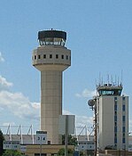
|
159 ft 48 m |
2011 | Ronkonkoma | At left in photo | [25] | ||
| Nassau Community College Administrative Tower | 
|
146 ft 45 m |
12 | 1978 | Uniondale | [7][26] | ||
| Kings Park Psychiatric Center Building 93 | 
|
143 ft 44 m |
13 | 1939 | Kings Park | [4][27][28] | ||
| Hofstra University Axinn Library |

|
140 ft 43 m |
11 | 1967 | Hempstead | [29] | ||
| Long Island Marriott | 
|
135 ft 41 m |
11 | 1982 | Uniondale | [7][17] | ||
| North Shore University Hospital | 
|
132 ft 40 m |
10 | 1976 | Manhasset | 40°46′39″N 73°42′06″W / 40.7775°N 73.7017°W | [30][31] | |
| 10 West Apartments (Avalon Towers) |

|
11 | 1990 | Long Beach | [32][33] | |||
| One Third Avenue | 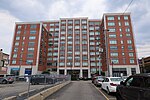
|
11 | 2016 | Mineola | Tallest building in Town of North Hempstead | [34] | ||
| Glenwood Generating Station | 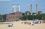
|
125 ft 38 m |
6 | 1931 | Glenwood Landing | Demolished; height excludes stacks on roof of building | 40°49′40″N 73°38′53″W / 40.8277°N 73.648°W | [4][35] |
| The Omni | 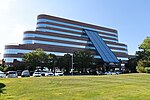
|
122 ft 37 m |
10 | 1990 | Uniondale | [7][17][36] | ||
| Long Beach Terrace | 
|
10 | 1965 | Long Beach | Two towers | [32][37] | ||
| Renaissance Condominiums | 
|
10 | 1985 | Long Beach | [32][38] | |||
| Hyatt Regency Long Island | 10 | 1986 | Happauge | [18][39] | ||||
| Seapointe Towers | 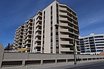
|
10 | 1988 | Long Beach | [32][40] | |||
| Islandia Marriott Long Island | 10 | 1988 | Islandia | [41] | ||||
| White Sands of Long Beach | 
|
10 | 2004 | Long Beach | [32][42] | |||
| Good Samaritan Hospital Medical Center | 120 ft 37 m |
1959 | West Islip | 40°41′46″N 73°17′41″W / 40.6962°N 73.2946°W | [4][43] | |||
| Montauk Point Lighthouse | 
|
110 ft 34 m |
N/A | 1796 | Montauk | Tallest building in Town of East Hampton | 41°04′16″N 71°51′26″W / 41.0710°N 71.8571°W | [1] |
| Pilgrim Psychiatric Center Building 25 | 
|
110 ft 34 m |
10 | Brentwood | [4][44] | |||
| Pilgrim Psychiatric Center Buildings 81 and 82 | 110 ft 34 m |
9 | Brentwood | Two towers | [4][44] | |||
| John P. Cohalan, Jr. Courthouse | 
|
9 | 1992 | Central Islip | [11] | |||
| Courthouse Corporate Center | 9 | 2003 | Central Islip | [11][45] | ||||
| The Financial Center | 
|
9 | 1986 | East Meadow | [10] | |||
| Garden City Hotel | 
|
9 | 1983 | Garden City | 40°43′28″N 73°38′26″W / 40.7244°N 73.6406°W | [46][47] | ||
| Wyndham Condominiums | 9 | 1989 | Garden City | Two buildings | [47] | |||
| Morgan Parc Apartments | 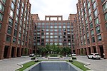
|
9 | 2020 | Mineola | [34] | |||
| Long Island MacArthur Airport old control tower |
|
107 ft 33 m |
7 | 1963 | Ronkonkoma | At right in photo; demolished in 2015 | [25][48][49] | |
| St. Patrick Catholic Church | 
|
106 ft 32 m |
N/A | 1900 | Glen Cove | [50] | ||
| Neptune Towers | 
|
106 ft 32 m |
10 | 1968 | Long Beach | [4][32][51] | ||
| Belmont Park Grandstand | 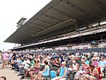
|
105 ft 32 m |
N/A | 1968 | Elmont | 40°42′54″N 73°43′22″W / 40.7150°N 73.7228°W | [52][53] | |
| Republic Airport control tower | 100 ft 30 m |
N/A | ca. 1970 | East Farmingdale | [54] | |||
| 666 Old Country Road | 
|
100 ft 30 m |
8 | 1980 | Uniondale | [5][47][55][56] | ||
| UBS Arena | 
|
100 ft 30 m |
N/A | 2021 | Elmont | Under construction | 40°42′44″N 73°43′38″W / 40.7121°N 73.7272°W | [57] |
Other structures[]
At least 300 feet[]
This list is incomplete; you can help by . (June 2021) |


Other notable structures at least 100 feet[]
This list is incomplete; you can help by . (June 2021) |
| Name | Image | Height | Opened | Location | Notes | Coordinates | Refs |
|---|---|---|---|---|---|---|---|
| Glenwood Generating Station |
|
265 ft 81 m |
1931 | Glenwood Landing | Demolished | 40°49′40″N 73°38′53″W / 40.8277°N 73.648°W | [4][35] |
| Wardenclyffe Tower | 
|
187 ft 57 m |
1901 | Shoreham | Demolished; built by Nikola Tesla | 40°56′51″N 72°53′54″W / 40.9476°N 72.8982°W | [64] |
| AN/FPS-35 radar tower | 
|
>118 ft 36 m |
1960 | Montauk | Concrete base is 80 feet (24 m) high Dish height is 38 feet (12 m) |
41°03′45″N 71°52′28″W / 41.0624°N 71.8745°W | [65][66] |
| Great South Bay Bridge | 
|
1954 | Great South Bay | 40°40′34″N 73°16′27″W / 40.6761°N 73.2742°W | |||
| Fire Island Inlet Bridge | 
|
1964 | Fire Island Inlet | 40°37′56″N 73°15′46″W / 40.6322°N 73.2628°W |
References[]
- ^ a b c d e f g h i j k l m n o p q r Lambert, Bruce (1999-11-14). "For the Few, a Breathtaking View; The Island Has Largely Resisted High-Rise Creep. But, Oh, the Scenery..." The New York Times. ISSN 0362-4331. Retrieved 2021-06-04.
- ^ a b c d e f g Egan, Matthew (2016-03-01). "The struggle to build bigger in Nassau and Suffolk" (PDF). The Real Deal New York. Retrieved 2021-06-08.
{{cite web}}: Cite has empty unknown parameter:|lay-url=(help)CS1 maint: url-status (link) - ^ a b Korman, Richard (2005-12-16). "The Defining Line". The New York Times. ISSN 0362-4331. Retrieved 2021-06-09.
The triangle [of the living room] is in New York City. The rest of the room is on Long Island.
- ^ a b c d e f g h i j k l m n o p q r s t u v w x y z aa ab ac ad ae af ag ah ai aj Morris, Tom (1974-09-22). "Up There! In the Air! It's Our Skyline!". Newsday (Suffolk Edition). p. 190. Retrieved 2021-06-05. Pages 2, 3, 4.
{{cite news}}: External link in|postscript= - ^ a b c d Lambert, Jr., Brudge (1981-06-06). "Taller Skyline for Mitchel Field". Newsday (Suffolk Edition). p. 7. Retrieved 2021-06-05.
{{cite news}}: CS1 maint: url-status (link) - ^ Johnston, Daniel (2018-12-13). "The Failed Lighthouse Project and How it Led to the Islanders New Arena". The Impact. Retrieved 2021-06-08.
{{cite web}}: CS1 maint: url-status (link) - ^ a b c d e f g h i j k "Nassau Hub Quarter 4 Development Report" (PDF). RXR Realty/Onexim Sports and Entertainment. 2020-01-31. pp. 3, 8. Retrieved 2021-06-08.
{{cite web}}: CS1 maint: url-status (link) - ^ a b "The tallest on Long Island". The New York Times. 1982-04-25. ISSN 0362-4331. Retrieved 2021-06-04.
- ^ "Tallest buildings in Stony Brook". Emporis. Retrieved 2021-06-04.
{{cite web}}: CS1 maint: url-status (link) - ^ a b "Tallest buildings in East Meadow". Emporis. Retrieved 2021-06-04.
{{cite web}}: CS1 maint: url-status (link) - ^ a b c "Buildings in Central Islip". Emporis. Retrieved 2021-06-04.
{{cite web}}: CS1 maint: url-status (link) - ^ Saslow, Linda (2008-05-18). "Jones Beach Tower Set for Restoration". The New York Times. ISSN 0362-4331. Retrieved 2021-06-04.
- ^ "Edgewood Hospital: Buildings". Edgewoodhospital.com. Retrieved 2021-06-05.
{{cite web}}: CS1 maint: url-status (link) - ^ "High-rise buildings in Deer Park". Emporis. Retrieved 2021-04-06.
{{cite web}}: CS1 maint: url-status (link) - ^ "Robert Moses State Park Celebrates 100th Anniversary". New York State Parks, Recreation, and Historic Preservation. 2008-06-27. Retrieved 2021-06-04.
{{cite web}}: CS1 maint: url-status (link) - ^ "Buildings in Huntington". Emporis. Retrieved 2021-06-04.
{{cite web}}: CS1 maint: url-status (link) - ^ a b c "Buildings in Uniondale". Emporis. Retrieved 2021-06-04.
{{cite web}}: CS1 maint: url-status (link) - ^ a b "Buildings in Hauppauge". Emporis. Retrieved 2021-06-04.
{{cite web}}: CS1 maint: url-status (link) - ^ "H. Lee Dennison Building: Case summary" (PDF). Suffolk County Department of Public Works. 2011-04-01. Retrieved 2021-06-17.
{{cite web}}: CS1 maint: url-status (link) - ^ "History: 1917 to 1951". The Cathedral of St. Agnes. Retrieved 2021-06-05.
{{cite web}}: CS1 maint: url-status (link) - ^ "History". Cathedral of the Incarnation. Retrieved 2021-06-05.
{{cite web}}: CS1 maint: url-status (link) - ^ "Lighthouses in Fire Island". Emporis. Retrieved 2021-06-04.
{{cite web}}: CS1 maint: url-status (link) - ^ "Kings Park Psychiatric Center - Building 7". 2013-09-21. Archived from the original on 2013-09-21. Retrieved 2021-06-05.
- ^ "Kings Park Psychiatric Center, Building 7". Do Not Look Down. 2019-10-30. Retrieved 2021-06-18.
{{cite web}}: CS1 maint: url-status (link) - ^ a b Armaghan, Sarah (2015-09-15). "Aging control tower at Long Island MacArthur Airport soon to be torn down". Newsday. Retrieved 2021-06-20.
{{cite web}}: CS1 maint: url-status (link) - ^ "Buildings in East Garden City". Emporis. Retrieved 2021-06-04.
{{cite web}}: CS1 maint: url-status (link) - ^ "Buildings in Kings Park". Emporis. Retrieved 2021-06-04.
{{cite web}}: CS1 maint: url-status (link) - ^ "Kings Park Psychiatric Center - Building 93". 2013-09-21. Archived from the original on 2013-09-21. Retrieved 2021-06-05.
- ^ "Buildings in Hempstead". Emporis. Retrieved 2021-06-04.
{{cite web}}: CS1 maint: url-status (link) - ^ Camurati, Amelia (2018-01-15). "North Shore University Hospital plans $342 million extension". The Island Now. Retrieved 2021-06-18.
{{cite web}}: CS1 maint: url-status (link) - ^ "Buildings in Manhasset". Emporis. Retrieved 2021-06-04.
{{cite web}}: CS1 maint: url-status (link) - ^ a b c d e f "Buildings in Long Beach". Emporis. Retrieved 2021-06-04.
{{cite web}}: CS1 maint: url-status (link) - ^ Winzelberg, David (2020-11-03). "AvalonBay sells its Long Beach rental complex for $54M". Long Island Business News. Retrieved 2021-06-05.
- ^ a b "Buildings in Mineola". Emporis. Retrieved 2021-06-04.
{{cite web}}: CS1 maint: url-status (link) - ^ a b "Alternative Use Analysis: Glenwood Power Station No. 2". Louis Berger Group, Inc. 25 June 2012. p. 9. Retrieved 2021-06-04.
{{cite web}}: CS1 maint: url-status (link) (Document starts on page 27 of file.) - ^ The Omni, LoopNet, retrieved 2021-06-18
- ^ "Long Beach Terrace Co-Op". LB Homes. Retrieved 2021-06-05.
{{cite web}}: CS1 maint: url-status (link) - ^ "Renaissance Condo". LB Homes. Retrieved 2021-06-05.
{{cite web}}: CS1 maint: url-status (link) - ^ "Hyatt Regency Long Island". Travel Weekly. Retrieved 2021-06-18.
{{cite web}}: CS1 maint: url-status (link) - ^ "Seapointe Towers Co-Op". LB Homes. Retrieved 2021-06-05.
{{cite web}}: CS1 maint: url-status (link) - ^ "Buildings in Islandia". Emporis. Retrieved 2021-04-06.
{{cite web}}: CS1 maint: url-status (link) - ^ "White Sands Condo". LB Homes. Retrieved 2021-06-05.
{{cite web}}: CS1 maint: url-status (link) - ^ Paquette, Carole (2001-02-11). "Modernization Picks Up Speed at Aging Hospitals". The New York Times. ISSN 0362-4331. Retrieved 2021-06-18.
- ^ a b "Tallest buildings in Brentwood". Emporis. Retrieved 2021-06-04.
{{cite web}}: CS1 maint: url-status (link) - ^ "Courthouse Corporate Center". LoopNet. Retrieved 2021-06-18.
{{cite web}}: CS1 maint: url-status (link) - ^ Winerip, Michael (1983-05-15). "Garden City Hotel returns in grand style". The New York Times. ISSN 0362-4331. Retrieved 2021-06-18.
- ^ a b c "Buildings in Garden City". Emporis. Retrieved 2021-06-04.
{{cite web}}: CS1 maint: url-status (link) - ^ Tadesse, Marco (2020-01-26). "The History of Long Island MacArthur Airport". Coast Private. Retrieved 2021-06-20.
{{cite web}}: CS1 maint: url-status (link) - ^ "MacArthur Airport Tower in Trouble". Newsday. 2006-12-14. Retrieved 2021-06-20 – via Aviation Pros.
{{cite web}}: CS1 maint: url-status (link) - ^ Russel, Daniel E. "The Bells of St Patrick's" (PDF). Glen Cove Heritage. Retrieved 2021-06-05.
{{cite web}}: CS1 maint: url-status (link) - ^ "Neptune Towers Co-Op". LB Homes. Retrieved 2021-06-05.
{{cite web}}: CS1 maint: url-status (link) - ^ "Belmont Park: Facility Details". New York Racing Association. Retrieved 2021-06-04.
{{cite web}}: CS1 maint: url-status (link) - ^ Kachejian, Brian (2018-01-04). "History of Belmont Park Racetrack". Classic New York History. Retrieved 2021-06-18.
{{cite web}}: CS1 maint: url-status (link) - ^ "Fairchild-Republic Aviation: The Jet Age". Long Island Republic Airport Historical Society. 2008. Retrieved 2021-06-21.
{{cite web}}: CS1 maint: url-status (link) - ^ "666 Old Country Rd". LoopNet. Retrieved 2021-06-18.
{{cite web}}: CS1 maint: url-status (link) - ^ Morgan, Jerry (1978-10-31). "9-Story Building Set For Roosevelt Field". Newsday. Retrieved 2021-06-05.
{{cite web}}: CS1 maint: url-status (link) - ^ O'Leary, Matt (2018-12-06). "New York Islanders New Arena Dimensions Leaked". Eyes On Isles. Retrieved 2021-06-04.
{{cite web}}: CS1 maint: url-status (link) - ^ a b c d e f g h i j k l m n o p q r s t u v w x y z aa "Antenna Structure Registration: Suffolk County, New York". U.S. Federal Communications Commission. Retrieved 2021-06-06.
{{cite web}}: CS1 maint: url-status (link) - ^ "RCA Radio Central". Rocky Point Historical Society. Retrieved 2021-06-05.
{{cite web}}: CS1 maint: url-status (link) - ^ a b "VFR Raster Charts: New York". U.S. Federal Aviation Administration. 2021-06-17. Retrieved 2021-06-05.
{{cite web}}: CS1 maint: url-status (link) - ^ Solnik, Claude (2005-02-04). "American Ref-Fuel to be sold for $2 billion". Long Island Business News. Retrieved 2021-06-06.
- ^ "DEC Permit Conditions Renewal" (PDF). New York State Department of Environmental Conservation. 2016-07-13. p. 33. Retrieved 2021-06-04.
{{cite web}}: CS1 maint: url-status (link) - ^ a b c d "Antenna Structure Registration: Nassau County, New York". U.S. Federal Communications Commission. Retrieved 2021-06-06.
{{cite web}}: CS1 maint: url-status (link) - ^ Stiefel, Natalie Aurucci. "Nikola Tesla at Wardenclyffe". Tesla Memorial Society of New York. Retrieved 2021-06-05.
{{cite web}}: CS1 maint: url-status (link) - ^ Rattiner, Dan (2014-11-06). "Camp Hero: Defending Montauk from the Nazis". Dan’s Papers. Retrieved 2021-06-10.
{{cite web}}: CS1 maint: url-status (link) - ^ "Montauk Air Force Station". The Historical Marker Database. Retrieved 2021-06-10.
{{cite web}}: CS1 maint: url-status (link)
- Long Island
- Lists of tallest buildings in New York (state)