South Midlands
South Midlands | |
|---|---|
| Country | United Kingdom |
| Constituent country | England |
| Region | East Midlands (part) East of England (part) South East England (part) |
| Counties |
|
| Counties included in some definitions | |
| Time zone | UTC+0 (Greenwich Mean Time) |
| • Summer (DST) | UTC+1 (British Summer Time) |
The South Midlands is a name used by different organisations for different purposes at different times. In 2008, the Government used it to describe an area of England which included Northamptonshire, the northern parts of Buckinghamshire and Oxfordshire and the western part of Bedfordshire, as one of the areas it for urban development. It is not one of the NUTS statistical regions of the United Kingdom like East Midlands or West Midlands.
An early definition[]
The 1851 census defined a South Midland division which comprised Middlesex (except the Metropolitan portion), Hertfordshire, Buckinghamshire, Oxfordshire, Northamptonshire, Huntingdonshire, Bedfordshire and Cambridgeshire.[1]
To understand why the South Midland division extends so far south, it may help to know that some 19th-century geographers defined a Central Plain consisting of the middle parts of England, lying between the valleys of the River Trent and the River Thames to the north and south, and between the Fen district and the high ground bordering the valley of the River Severn to the east and west.[2]
Milton Keynes and South Midlands growth area[]
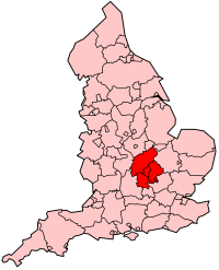
In 2008, the Government referred to an area centred on the Borough of Milton Keynes as the Milton Keynes and South Midlands growth area. This area comprises the whole of Bedfordshire, the whole of Northamptonshire, and parts of Buckinghamshire (the borough of Milton Keynes and other parts of north Buckinghamshire) and may be understood to extend into neighbouring Harborough district in south Leicesteshire and Rugby.[citation needed] It straddles the boundaries of other regions of England, including portions of the East Midlands, East of England and South East England.[3]
The main settlements are Aylesbury, Milton Keynes, Northampton, Corby, Kettering, Wellingborough, Rushden, Bedford and Luton. A report in 2002 found that: "The most successful economies are those of Milton Keynes and Northampton. Bedford, Corby and the Luton/Dunstable/Houghton Regis area are in need of regeneration."[4] The region is served by London Luton Airport (the fifth busiest airport in the United Kingdom), and has important road and rail links, being served by the M1 motorway and both the West Coast and East Coast main lines, connecting it with London, Birmingham and the north of England.
Other examples[]
- The Council for British Archaeology South Midlands region covers Bedfordshire, Buckinghamshire, Northamptonshire and Oxfordshire.[5]
- The English Powerlifting Association South Midlands district covers the counties of Oxfordshire, Berkshire, Buckinghamshire, Hampshire, and the Isle of Wight.[6]
- Some Joint Industrial Councils defined the South Midlands as Berkshire, Buckinghamshire, Oxfordshire, Hampshire, Wiltshire, the Isle of Wight, and the Channel Islands, most of which would not usually be considered part of the area but sooner as south central England.[citation needed]
- The Pagan Federation South Midlands district covers Bedfordshire, Buckinghamshire, Hertfordshire, Northamptonshire and Oxfordshire.[7]
- The South Midlands League was formed by football teams from Bedfordshire and some adjoining counties.
See also[]
- Historical and alternative regions of England
- Cambridge - Milton Keynes - Oxford corridor
- North Midlands
- East Midlands
- West Midlands
References[]
- ^ Map of the South Midlands Counties.
- ^ W. Hughes, Manual of British Geography, 1851, page 15.
- ^ Milton Keynes South Midlands Archived 1 August 2008 at the Wayback Machine.
- ^ Roger Tym and Partners, Milton Keynes and South Midlands Study: Final Report of the Study, Chapter 8: Conclusions Archived 14 October 2006 at the Wayback Machine.
- ^ Council for British Archaeology South Midlands Region.
- ^ https://www.englishpowerlifting.co.uk/english-divisions Divisions of the English Powerlifting Association]
- ^ The Pagan Federation, South Midlands.

- Regions of England
- Bedfordshire
- Buckinghamshire
- Northamptonshire