South River (North Carolina)
| South River Tributary to Black River | |
|---|---|
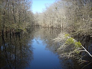
 The South River near Autryville, North Carolina | |
 Location of South River mouth | |
| Location | |
| Country | United States |
| State | North Carolina |
| County | Bladen Cumberland Pender Sampson |
| Physical characteristics | |
| Source | confluence of Mingo Swamp and Black River |
| • location | about 1 mile northeast of Falcon, North Carolina |
| • coordinates | 35°12′29″N 078°37′49″W / 35.20806°N 78.63028°W[1] |
| • elevation | 118 ft (36 m)[2] |
| Mouth | Black River |
• location | about 0.25 miles downstream of Bakers Landing |
• coordinates | 34°35′00″N 078°16′10″W / 34.58333°N 78.26944°WCoordinates: 34°35′00″N 078°16′10″W / 34.58333°N 78.26944°W[1] |
• elevation | 13 ft (4.0 m)[2] |
| Length | 78.47 mi (126.29 km)[3] |
| Basin size | 477.31 square miles (1,236.2 km2)[4] |
| Discharge | |
| • location | Black River |
| • average | 549.68 cu ft/s (15.565 m3/s) at mouth with Black River[4] |
| Basin features | |
| Progression | generally southeast |
| River system | Black River |
| Tributaries | |
| • left | Williamson Swamp Jones Swamp Big Swamp Castle Mill Creek Jumping Run Creek Tomahawk Creek Enoch Mill Creek |
| • right | Browns Swamp Big Creek Sandy Creek Beaver Dam Creek Peters Creek Cypress Swamp Long Branch South Mill Pond Run Lake Creek |
| Bridges | Green Path Road, US 13, Hayes Mill Road, Maxwell Road, Faircloth Bridge Road, Autry Highway (NC 24), Clinton Road, S Gray Street, Butler Island Bridge Road, Elzabethtown Highway, Melvins Bridge Road, Greens Bridge Road, Helltown Road, US 701, Tomahawk Highway (NC 41), Wildcat Road |
The South River is a tributary of the Black River, approximately 78.47 mi (126.29 km) long,[4] in southeastern North Carolina in the United States.
It rises 2 miles Northeast of Falcon, North Carolina on the Cumberland and Sampson County line at the confluence of Mingo Swamp and the smaller Black River.[2] The smaller Black River flows 30 miles from northeastern Harnett County, in Angier and approximately 25 mi (40 km) south of Raleigh. The smaller Black River flows SSE past Benson, then SSW passing west of Dunn. East of Fayetteville, the South River turns SSE and joins the larger Black River near Ivanhoe, North Carolina approximately 30 mi (48 km) northwest of Wilmington.
Fishing[]
The South River is home to a wide variety of fish species, including Largemouth Bass, chain pickerel,[5] various species of sunfish, longnose gar, and catfish. To navigate through the river, a kayak or a small jon boat is recommended.
See also[]
- List of North Carolina rivers
References[]
- ^ a b "GNIS Detail - South River". geonames.usgs.gov. US Geological Survey. Retrieved 16 October 2019.
- ^ a b c "South River Topo Map, Sampson County NC (Rowan Area)". TopoZone. Locality, LLC. Retrieved 16 October 2019.
- ^ "ArcGIS Web Application". epa.maps.arcgis.com. US EPA. Retrieved 15 October 2019.
- ^ a b c "South River Watershed Report". Waters Geoviewer. US EPA. Retrieved 16 October 2019.
- ^ "Fishing Opportunities in the Coastal Region of North Carolina". www.ncwildlife.org. Retrieved 2020-09-15.
- Rivers of North Carolina
- Rivers of Harnett County, North Carolina
- Rivers of Johnston County, North Carolina
- Rivers of Cumberland County, North Carolina
- North Carolina river stubs

