South San Jose
South San Jose | |
|---|---|
Region of San Jose, California | |
 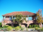   Clockwise: Almaden Lake Park in Almaden Valley; Valley Christian High School in Edenvale; Hayes Mansion in Edenvale; Old Almaden Winery in Almaden Valley. | |
| Population | |
| • Total | 406,000[1][2][3][4][5][6] |
| Zip codes | 95111, 95119, 95120, 95123, 95136, 95138, 95139, 95193 |
South San Jose is the southern region of San Jose, California. The name "South Side" refers to an area bounded roughly by Hillsdale Avenue and Capitol Expressway to the North, Camden Avenue to the West, Highway 101 and Hellyer Avenue on the east, the border with the city of Morgan Hill towards the south, and Los Gatos, to the west.[7]
The area is expansive with a mix of businesses, green space, and parks. Two business districts, urban villages and a highly educated workforce make the neighborhood attractive to workers and companies.[8]
Neighborhoods[]

Aerial view of South San Jose
Neighborhoods in South San Jose include:
- Almaden Valley
- Blossom Valley
- Edenvale
- Santa Teresa
- Seven Trees
Light rail stations[]
- Capitol (VTA)
- Branham (VTA)
- Ohlone-Chynoweth (VTA)
- Almaden (VTA)
- Blossom Hill (VTA)
- Snell (VTA)
- Cottle (VTA)
- Santa Teresa (VTA)
Parks and trails[]
- Coyote Creek Trail
- Guadalupe River Trail
- Almaden Quicksilver County Park
- Santa Teresa County Park
- Martial Cottle Park
Major highways[]
See also[]
References[]
- ^ "Silver Creek Demographics & Statistics - Employment, Education, Income Averages in Silver Creek". www.point2homes.com.
- ^ "Almaden Valley Demographics & Statistics - Employment, Education, Income Averages in Almaden Valley". www.point2homes.com.
- ^ "Living in Blossom Valley". Niche.
- ^ "The Demographic Statistical Atlas of the United States - Statistical Atlas". statisticalatlas.com.
- ^ "Edenvale Demographics & Statistics - Employment, Education, Income Averages in Edenvale". www.point2homes.com.
- ^ "Santa Teresa Demographics & Statistics - Employment, Education, Income Averages in Santa Teresa". www.point2homes.com.
- ^ "South San Jose, San Jose, CA". Google Maps. Retrieved 30 March 2018.
- ^ "South San Jose | City of San Jose". www.sjeconomy.com. Retrieved 2021-05-10.
Coordinates: 37°14′19″N 121°50′18″W / 37.238635°N 121.838336°W


Categories:
- Neighborhoods in San Jose, California
- Geography of San Jose, California
- San Jose, California stubs