Southampton Parish, Bermuda

Southampton Parish is one of the nine parishes of Bermuda. It is named for Henry Wriothesley, 3rd Earl of Southampton (1573-1624).
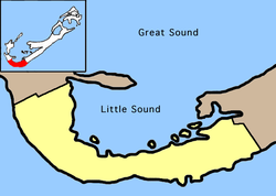
It is located in the southwest of the island chain, occupying all of the western part of the main island, except for the westernmost tip (which is part of Sandys Parish). It includes the chain's southernmost point, and its north coast comprises much of the coast of the Little Sound (an arm of the Great Sound, the large expanse of water which dominates the geography of western Bermuda). in the east it is joined to Warwick Parish. As with most of Bermuda's parishes, it covers just over 2.3 square miles (about 6.0 km2 or 1500 acres). It had a population of 6,421 in 2016.[1]
Natural features in Southampton include , Church Bay, Horseshoe Bay, and .
Other notable features of Southampton include the , and Gibbs Hill Lighthouse, which stands on the chain's highest point.
Education[]
Schools in the parish:
- Southampton Preschool[2]
- Heron Bay Primary School[3]
- Port Royal Primary School[4]
- Dalton E. Tucker Primary School[5]
- Bermuda Institute (private school)
Sports[]
Southampton Rangers football club play their home games at the Southampton Oval.
References[]
- ^ "Bermuda 2016 Census" (PDF). Bermuda Department of Statistics. December 2016. Retrieved 22 March 2020.
- ^ Home. Southampton Preschool. Retrieved on September 14, 2016.
- ^ Home. Heron Bay Primary School. Retrieved on September 14, 2016.
- ^ Home. Port Royal Primary School. Retrieved on September 14, 2016.
- ^ Home. Dalton E. Tucker Primary School. Retrieved on September 14, 2016.
External links[]
| hide | ||
|---|---|---|
| Municipalities | ||
| Parishes | ||
| Authority control |
|---|
Coordinates: 32°15′00″N 64°51′00″W / 32.25000°N 64.85000°W

This Bermuda location article is a stub. You can help Wikipedia by . |
- Southampton Parish, Bermuda
- Parishes of Bermuda
- Bermuda geography stubs