Southport, Connecticut
Southport, Connecticut | |
|---|---|
 A view of Southport Harbour from neighboring Sasco Hill. | |
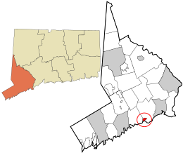 Location in Fairfield County and the state of Connecticut. | |
| Coordinates: 41°7′55″N 73°17′4″W / 41.13194°N 73.28444°WCoordinates: 41°7′55″N 73°17′4″W / 41.13194°N 73.28444°W | |
| Country | |
| U.S. state | |
| County | Fairfield |
| Metropolitan area | Bridgeport-Stamford |
| Town | Fairfield |
| Settled | 1639 |
| Incorporated (borough) | 1831 |
| Disincorporated | 1854 |
| Area | |
| • Total | 0.992 sq mi (2.57 km2) |
| • Land | 0.858 sq mi (2.22 km2) |
| • Water | 0.134 sq mi (0.35 km2) |
| Population (2010) | |
| • Total | 1,585.[1] |
| ZIP Code | 06890 |
| Area code | 203/475 |
| FIPS code | 09-71040 |
| GNIS feature ID | 2631576[2] |

Southport is a census-designated place (CDP) in the town of Fairfield, Connecticut. It is located along Long Island Sound between Mill River and Sasco Brook, where it borders Westport. As of the 2010 census, it had a population of 1,585.[1] Settled in 1639, Southport center has been designated a local historic district since 1967, and was listed on the National Register of Historic Places in 1971 as the Southport Historic District.
History[]

The earliest recorded event in Southport's history was "The Great Swamp Fight" or "Fairfield Swamp Fight" of July 1637 (not to be confused with the later Great Swamp Fight of King Philip's War), an episode of the Pequot War in which English colonial forces led by John Mason and Roger Ludlow vanquished a band of about 80 to 100 Pequot Indians who had earlier fled from their home territory in the Mystic area and had taken refuge with about 200 Sasqua Indians who inhabited the area that is now Fairfield. The exact location of the battle is not known, but it is known to have been in the vicinity of Southport.[3]
In the eighteenth century, Mill River village, a part of Fairfield, was a small hamlet of a few houses and a wharf at the mouth of Fairfield's Mill River. Farm products from the surrounding area were shipped from Mill River's small harbor to ports in New York and beyond.[4]
By 1831 the village had changed its name to Southport and was a bustling commercial area with warehouses, churches, schools, stores and elegant houses. Before 1853, Southport had its own local government as a borough within the town of Fairfield.[5] Southport became a leading coastal port on Long Island Sound, its ships carrying produce and goods back and forth to New York City. A measure of Southport's success is the fact that throughout the 1800s it possessed the only two banks in town. However, competition from steamboats and the railroad took its toll on prosperity. Resourceful shippers teamed with local farmers and businessmen to keep the port going; the Southport onion, a high quality onion, was developed and grown on Fairfield's hills and shipped in Southport market boats, keeping the harbor profitable until the end of the century. In the 1890s, 100,000 barrels of locally grown onions, carrots, potatoes, and other goods were shipped annually from Southport harbor.[4]
Today, much of the old village area is part of a town historic district, first established in 1967, where buildings from three centuries are protected for future generations. The boundaries of the town historic district are the railroad on the north; the Mill River and Southport Harbor on the south; Church Street; and Old South Road and Rose Hill Road on the west and east, respectively, including all properties on both sides of the roads.[6] Strict historic zoning regulations apply in the district and have been upheld by the Connecticut Supreme Court.[6][7] The Southport Historic District is also listed on the National Register of Historic Places.
Geography[]
According to the United States Census Bureau, Byram has a total area of 0.992 square miles (2.57 km2), of which 0.858 square miles (2.22 km2) is land and 0.134 square miles (0.35 km2), or 13.51%, is water.[8]
Demographics[]

The main village of Southport corresponds to census tract 606. As of the census[9] of 2000, there were 2,201 people in the village, organized into 998 households and 606 families. The racial makeup of the town was 95.6% White, 2.3% Asian, 0.6% African American, 0.1% Native American, 0.1% Pacific Islander, 0.5% from other races, and 0.7% from two or more races. 1.6% of the population were Hispanic or Latino of any race.
There were 998 households, out of which 22.7% had children under the age of 18 living with them, 50.1% were married couples living together, 8.3% had a female householder with no husband present, and 39.3% were non-families. 33.1% of all households were made up of individuals, and 15.8% had someone living alone who was 65 years of age or older. The average household size was 2.21 and the average family size was 2.81.
The median income for a household in the village was $140,307, and the median income for a family was $183,023. Males had a median income of $131,695 versus $55,475 for females. The per capita income for the village was $66,432. 2.0% of the population and 1.1% of families were below the poverty line. Out of the total population, 1.5% of those under the age of 18 and 2.7% of those 65 and older were living below the poverty line.
Public services[]


Southport has had its own firefighting service since 1895. The Southport Fire Department was organized that year as a volunteer fire department after a large arson fire in the village. However, it is also protected by Fairfield Fire Department's Engine 4, out of the Southport Firehouse.[10]
The community's public library is the Pequot Library, housed in a Romanesque building, designed by the architect Robert Henderson Robertson and built in 1887,[5] that is a contributing property to the National Register Southport Historic District.[11] The library is reputed to have a large collection of old and rare books.[5] The library's annual summer book sale featured more than 140,000 volumes on sale in 2007.[12] In 2006, the Pequot Library invested in a restoration project to address the condition of the elaborate metalwork set throughout their stacks. Robert Robertson designed each shelf in the library to be supported by cast iron structures. Each row of shelving is framed by columns and the stairways linking the two storeys are made with balusters of garlands and vines in copper plated cast iron. During the course of restoration, over 6,000 metal pieces were individually treated. The project was carried out by Newmans’ Ltd.[13]
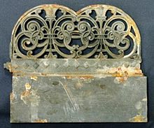 Pequot Library baseboard before restoration |
 Pequot Library baseboard completed by Newmans' Ltd |
The neighborhood's ZIP Code is 06890, whose scope extends further north from the historic village area to include the Mill Hill area.
Education[]
Eagle Hill School-Southport, a private day school for children with learning disabilities, has been located since 1985 in the former Pequot School in Southport. The historic school building was earlier acquired by the Southport Conservancy to save it from demolition.[14][15]
Southport is served by the Fairfield Public Schools. Southport is home to Mill Hill Elementary School, although children in some areas considered part of the Southport neighborhood but outside the census tract attend Timothy Dwight Elementary School. Both Mill Hill and Dwight Schools feed into Roger Ludlowe Middle School, Tomlinson Middle School and Fairfield Ludlowe High School.[16]
Transportation[]
The main arterial road in the area, the Post Road (US Route 1), runs through Southport, connecting it to other towns along the Connecticut coast. Interstate 95 also passes through Southport, with two exits located in the neighborhood. Southport is also served by the New Haven Line of the Metro-North Commuter Railroad at Southport Railroad Station, with frequent trains to New Haven and New York City.[17] Limited bus service is provided by the Greater Bridgeport Transit Authority.
Notable people[]

The following are among the notable people who have lived in Southport:
- James Truslow Adams, historian and writer
- John Akers, former chief executive officer of IBM[5]
- Anatole Broyard, author[5]
- Ina Garten, celebrity cook and author
- Jeffrey Garten, economic adviser and author
- Don Imus, radio personality
- Richard Clarida, Vice Chairman of the Federal Reserve, Economist
- Kenton Clarke, CEO, Computer Consulting Associates International Inc.
- Samuel J. Palmisano, former chief executive officer of IBM
- Jason Robards, actor, producer and director[5]
- Ira Dever Warner,[18] inventor, founder of Warner Corset Company
- Jack Welch, former CEO General Electric
Movies filmed in Southport[]
- Revolutionary Road (2007)
- And So It Goes (2014)
References[]
- ^ Jump up to: a b "Race, Hispanic or Latino, Age, and Housing Occupancy: 2010 Census Redistricting Data (Public Law 94-171) Summary File (QT-PL), Southport CDP, Connecticut". United States Census Bureau. Retrieved August 11, 2011.
- ^ U.S. Geological Survey Geographic Names Information System: Southport, Connecticut
- ^ http://www.fairfieldhs.org/explore-fairfield-history.php#great Archived 2008-07-23 at the Wayback Machine
- ^ Jump up to: a b History of the Town of Fairfield, Connecticut
- ^ Jump up to: a b c d e f Charles, Eleanor. "If You're Thinking of Living in; Southport", New York Times, December 22, 1985.
- ^ Jump up to: a b Gibbons v. Fairfield Historic District Commission, 285 Conn. 755; 941 A.2d 917; 2008 Conn. LEXIS 80
- ^ An Enclave for One’s Inner Scarlett, New York Times, June 12, 2009
- ^ "US Gazetteer files: 2019". United States Census Bureau. Retrieved 2020-10-10.
- ^ "U.S. Census website". United States Census Bureau. Retrieved 2008-01-31.
- ^ Abbreviated History of The Southport Fire Department, Southport Fire Department Corp. website, accessed June 17, 2009
- ^ Economic Development & Affordable Housing, Congressman Jim Himes' website, accessed July 13, 2009
- ^ "Calendar" section of The Norwalk Citizen-News, July 27, 2007, p. A35
- ^ Newmans' Ltd. Art Restoration
- ^ History, Eagle Hill-Southport website, accessed October 13, 2009
- ^ Southport Conservancy website, accessed October 13, 2009
- ^ [1], Fairfield Public Schools website, accessed September 1, 2010
- ^ Governor Rell Announces Plan to Rebuild Southport Train Station; Demolition Unnecessary; Building Can Be Salvaged, Connecticut Department of Transportation press release, 2/20/2008
- ^ "Restmore marks inclusion on National Register". Connecticut Post. Retrieved 2016-02-08.
External links[]
| Wikimedia Commons has media related to Southport, Connecticut. |
| Wikivoyage has a travel guide for Southport, Connecticut. |
- The Southport Conservancy (organization for preservation and restoration of historic properties in Southport)
- The Southport Globe (a website focused on the community)
- The Southport Picture File (a collection of 800 historical photos compiled by historian V. Louise Higgins. Housed at Pequot Library and accessible online.)
- Living in Southport, Conn. (New York Times photo collection)
- Brilvitch, Charles. 1977. Walking Through History. The Seaports of Black Rock and Southport. Fairfield Historical Society.
| show Municipalities and communities of Fairfield County, Connecticut, United States |
|---|


| show New York metropolitan area |
|---|

| show Authority control |
|---|
- Fairfield, Connecticut
- Neighborhoods in Connecticut
- Populated coastal places in Connecticut
- Census-designated places in Fairfield County, Connecticut
- Census-designated places in Connecticut