Southsea Railway
Railways in the Portsmouth area | ||||||||||||||||||||||||||||||||||||||||||||||||||||||||||||||||||||||||||||||||||||||||||||||||||||||||||||||||||||||||
|---|---|---|---|---|---|---|---|---|---|---|---|---|---|---|---|---|---|---|---|---|---|---|---|---|---|---|---|---|---|---|---|---|---|---|---|---|---|---|---|---|---|---|---|---|---|---|---|---|---|---|---|---|---|---|---|---|---|---|---|---|---|---|---|---|---|---|---|---|---|---|---|---|---|---|---|---|---|---|---|---|---|---|---|---|---|---|---|---|---|---|---|---|---|---|---|---|---|---|---|---|---|---|---|---|---|---|---|---|---|---|---|---|---|---|---|---|---|---|---|---|
| ||||||||||||||||||||||||||||||||||||||||||||||||||||||||||||||||||||||||||||||||||||||||||||||||||||||||||||||||||||||||

The Southsea Railway was a branch of the Portsmouth Direct Line, located on Portsea Island, Hampshire in the United Kingdom. The railway was opened on 1 July 1885 and closed on 6 August 1914.
History[]
In 1879, South Parade Pier was opened by Princess Edward of Saxe-Weimar[1] in Southsea, a fashionable Victorian seaside resort in southern Portsmouth.
South Parade Pier, measuring 1,960 feet (600 m) in length, began operating a passenger steamer service across the Solent to the Isle of Wight. This service gave rise to the idea of linking Southsea and its pier to Portsmouth's railway line, bypassing the busy town of Portsmouth and its crowded harbour. A similar scheme had already been operating between Clarence Pier and Portsmouth Town railway station since 1861.[2]
The Southsea Railway Company was founded by Edwin Galt, who had been the mayor of Portsmouth from 1868 to 1869.[2] Work on the new line began in March 1884, with Princess Edward of Saxe-Weimar cutting the first sod.[2]
The first and original terminus station of the Southsea Railway was named Southsea and was built in a grand Queen Anne style. The station was located 50 yards (46 m) to the north of Granada Road, Southsea,[3] and south of the southern side of St. Simon's Church, in St. Ronan's Road, Southsea. The station and its tracks were orientated diagonally north-east in parallel with the southern side of St. Ronan's Road, and had three 360 feet (110 m) long platforms[4] under a glass paned roof.
Southsea station, along with the Southsea Railway and Fratton railway station were jointly opened on 1 July 1885 by Lady Ada Mary Willis[4] (née Neeld), wife of General Sir George Willis, the Lieutenant Governor of Portsmouth.[5] The Southsea Railway was built to serve the fashionable Victorian seaside resort of Southsea, and at its northern end, the Southsea Railway connected to the Portsmouth Direct Line at Fratton railway station.
The Southsea Railway line was an uninterrupted 1.25 miles (2 km) long, using cuttings excavated to pass under Old Bridge Road and Albert Road, then under earth-bank road bridges built at Devonshire Avenue and Goldsmith Avenue.[2][6] At the railway lines northern end, after passing underneath the Goldsmith Avenue road bridge, it connected to a dedicated island platform at Fratton railway station - itself purposely built as an interchange station for the Southsea Railway and Portsmouth Direct Line.
Fratton Station was also opened on the same day that the Southsea Railway was. An earlier alternative location for the Southsea Railway interchange station was originally planned at the newly built Station Road in Copnor, Portsmouth, but was not constructed, instead built at Fratton. Ironically, Copnor's Station Road still exists today, near to Copnor Bridge.[7]
By the twentieth century, the Southsea Railway was experiencing competition with Portsmouth Corporation Transport electric trams and trolleybuses. Conventional steam trains on the line were replaced in 1903 with 56 feet (17 m) long steam railcars. The steam-powered railcars had small wheels and allegedly gave passengers a bumpy ride.[4]
In 1904, the original 1885 Southsea station building was leased out to a motor engineer business as a cost-cutting measure, the Southsea Railway terminus then moved 50 yards (46 m) south to a much smaller single wooden platform station named East Southsea, built directly on Granada Road itself.[3][4] Two unstaffed station halts were added in 1904 at Jessie Road and Albert Road[8]
Sadly, on 19 July 1904, South Parade Pier was destroyed by fire, before being rebuilt and reopening on 12 August 1908.
On 4 July 1905, Fratton railway station's name was changed to Fratton & Southsea.[9]
The First World War, closure and fate[]
By 1914, the threat of the First World War loomed. The final nail in the Southsea Railway's coffin was a government directive issued shortly after the declaration of war to the effect that railways unable to support themselves would cease operations at the earliest opportunity; and, as the line clearly fell into this category, the last train ran on 6 August 1914.[4] The original 1885 Southsea station at Granada Road was used as an munitions store during the war,[4] while the rail line itself served as an additional overflow siding from Fratton railway station's goods yard.
After the war, the Southsea Railway and its stations lay abandoned. Partial removal of the line was sanctioned by Section 55 of the Southern Railway Act 1923. The 1885 Southsea station at Granada Road was converted into a road vehicle garage business,[4] until it was demolished in the 1970s[10] and later replaced with a residential cul de sac called Chewter Close which was named after former 1995 Portsmouth mayor, Malcolm Chewter.
Legacy[]
After the demise of the Southsea Railway, Fratton & Southsea station reverted to its original Fratton name on 1 December 1921.[9]
The Southsea station name was later transferred to Portsmouth's main Portsmouth Town railway station in 1925[9] creating the present-day Portsmouth & Southsea railway station name. Portsmouth was elevated to city status a year later in 1926.
Southsea Railway route today[]
After its closure, the route of the Southsea Railway line was mostly redeveloped for housing, although its distinctive curved route can still be traced on a modern street map of present-day Portsmouth, and compared with period maps of the early twentieth century.[3]
The site of Southsea's terminus station is now occupied by a modern residential cul de sac named Chewter Close, just to the north of Granada Road in Southsea.[11] The original 1885 terminus station building was located at the northern end of today's Chewter Close until its demolition in the 1970s. A mural commemorating the station was unveiled on the northernmost wall in Chewter Close on 26 August 2011.[12] The smaller, later East Southsea station site is now occupied by modern houses at the junction of Chewter Close and Granada Road.
Immediately to the north of Chewter Close, the Southsea Railway line followed the route of today's Parkstone Avenue, a mid-twentieth century development of semi-detached houses that covered the southern end of the line.[3] To the north of Parkstone Avenue, the railway route passed through a bridge cutting under the eponymously named Old Bridge Road.[3][13]
The route of the former Southsea Railway continued northwards in a narrow cutting between St. Ronan's Road and Craneswater Avenue, now filled and occupied by housing.[14] Further to the north, the line ran alongside the eastern side of Craneswater School and passed through the Albert Road bridge cutting (since demolished and filled in).[3][15] The route is now covered by a small school car park, games courts and turfed playing fields,[16] this land previously had an Odeon ('Salon' from 1977) cinema built on it in 1937 before closure and demolition in 1985.[17]
Through the Albert Road bridge cutting, the line passed under what is now 253 Albert Road, a dry-cleaners store. Beside this, at 251 Albert Road, the railway passed alongside a building once called the Gaiety Cinema, which has since been converted into a modern-day Co-op supermarket.[18] The shape of the Co-op building's east side wall still follows the same angle as the former railway line route.
Following the route north from Albert Road, there is now Festing Mews, a collection of lockup garages built over the Southsea Railway line route.[19] Continuing northwards, the route passed through what is now Pepys Close, a row of twentieth century bungalows.[20]
North of Pepys Close, a brick wall now blocks the route northwards into a wide present-day back alleyway that passes between the backs of terraced houses in Bath Road and St. Augustine Road.[21] The Southsea Railway line once passed through this alleyway and emerged at today's expanded Devonshire Avenue, the former location of Jessie Road Bridge Halt railway station. A road bridge was formerly built above this station, and connected Jessie Road in the west to Devonshire Avenue in the east. A turfed island in the centre of the present day Devonshire Avenue marks the location of the eastern half end of the demolished bridge.[22]
North of Devonshire Avenue, the Southsea Railway route began its northwest arc to link with Fratton railway station. The arc originally followed directly behind the back of terraced houses in Heidelberg Road, and then to the north of house fronts in Francis Avenue.[23] The original railway route is now covered by the extended Fernhurst Road and the addition of Chestnut Avenue. The houses in these newer roads are of a later style to those found in Heidelberg Road and Francis Avenue.
From the north side of Francis Avenue, the Southsea Railway line then travelled beneath an earth-bank road bridge built at an angle over the top of Goldsmith Avenue and down into Fratton railway station.[24] The bridge, since demolished, once occupied land on Goldsmith Avenue which presently has a large modern Lidl supermarket on it. The supermarket replaced an earlier Danepak Bacon building, built after the bridge and Southsea Railway route were demolished.
North of the Goldsmith Avenue bridge, the Southsea Railway route once terminated at its own dedicated covered platform island at Fratton railway station, south of the main station buildings and platforms.[25] The island was built just to the east of the main Fratton station overhead footbridge, which previously had a flight of stairs leading down to the Southsea Railway's island platforms. This island at Fratton station was demolished after the Southsea Railway line closed, a modern train washing facility now occupies the site.[26]
Alternative stations[]
Southsea is now served by stations at Fratton, Portsmouth & Southsea, and Portsmouth Harbour (also called The Hard), with regular trains to London Waterloo and coastway services.[27]
Gallery[]
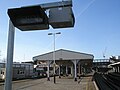
The Southsea Railway departed Fratton Station from a dedicated island platform, now the location of a modern train washing machine.

The route crossed Goldsmith Avenue on a bridge before curving round Francis Avenue and behind Heidelberg Road.

Old Bridge Road in Southsea, which carried the Southsea Railway

until it approached the terminus just north of Granada Road.

The south side of St. Simon's Church in St. Ronan's Road, Southsea which is located to the immediate north of the site of the original railway terminus building.


Southsea Railway expansion[]
According to a 18 June 2016 article by Bob Hind of Portsmouth's The News newspaper, plans for an expansion to the Southsea Railway network were once considered, but were ultimately never built.[28]
The expansion plan would have created a junction at Goldsmith Avenue for trains from either Southsea, Fratton or Portsmouth to travel along the northern side of Goldsmith Avenue to the road junction of Milton Road, following the exact former Portsmouth & Arundel Canal route through Milton, to the disused lock gates at Locksway Road beside Langstone Harbour.
A new bridge across Langstone Harbour would have linked Portsea Island directly to Hayling Island by rail, and connect to the Hayling Island branch line. This, if ever created would have created a large railway loop in south east Hampshire, as the Hayling Island branch line continued north to Havant railway station on the mainland, which in turn was connected to the Portsmouth Direct Line railway.
As noted by the newspaper article,[28] this plan might have prevented the closure of the Hayling Island branch line on 2 November 1963. But as the Southsea Railway itself closed before this date in 1914, the alleged expansion plan was never seriously considered.
References[]
- ^ "The History of South Parade Pier". Southparadepier.net.
- ^ a b c d "History In Portsmouth". Historyinportsmouth.co.uk. Retrieved 14 November 2021.
- ^ a b c d e f "View map: Hampshire & Isle of Wight LXXXIII.SE (Includes: Alverstoke; Portsmouth.) - Ordnance Survey Six-inch England and Wales, 1842-1952". Maps.nls.uk.
- ^ a b c d e f g "Southsea Railway, Fratton". Portsmouth-guide.co.uk.
- ^ "History in Portsmouth". Historyinportsmouth.co.uk.
- ^ "Southsea Railway, Fratton". Portsmouth-guide.co.uk. Retrieved 14 November 2021.
- ^ "Google Maps". Google.co.uk. Retrieved 14 November 2021.
- ^ "The Southsea Railway" Robertson,K: Southampton, Kingfisher, 1985 ISBN 0-946184-16-X
- ^ a b c "None". Starzina.com. Retrieved 14 November 2021.
- ^ History in Portsmouth (with further history and photos of the station and railcar), History.inportsmouth.co.uk
- ^ "Google Maps". Google.co.uk.
- ^ [1][dead link]
- ^ "Google Maps". Google.co.uk.
- ^ "Google Maps". Google.co.uk.
- ^ "Google Maps". Google.co.uk.
- ^ "Google Maps". Google.co.uk.
- ^ "Salon Cinema in Southsea, GB". Cinematreasures.org.
- ^ "Gaiety Cinema, Albert Road". Portsmouthandsouthsea.co.uk. Retrieved 14 November 2021.
- ^ "Google Maps". Google.co.uk.
- ^ "Google Maps". Google.co.uk.
- ^ "Google Maps". Google.co.uk.
- ^ "Google Maps". Google.co.uk.
- ^ "Google Maps". Google.co.uk.
- ^ "Google Maps". Google.co.uk.
- ^ "View map: Hampshire & Isle of Wight LXXXIII.NE (Includes: Portsmouth.) - Ordnance Survey Six-inch England and Wales, 1842-1952". Maps.nls.uk.
- ^ "Google Maps". Google.co.uk.
- ^ "Woking to Portsmouth" Mitchell,V/Smith,K: Midhurst, Middleton Press,1984 ISBN 978-0-906520-25-3 OCLC 60024110
- ^ a b [2][dead link]
- Rail transport in Hampshire
- Transport in Portsmouth
- Closed railway lines in South East England
- Railway lines opened in 1885