List of cities in the United Kingdom
This is a list of cities in the United Kingdom that are officially designated such as of 2015.[1] It lists those places that have been granted city status by letters patent or royal charter. There are currently a total of 69 such cities in the United Kingdom: 51 in England, seven in Scotland, six in Wales, and five in Northern Ireland.[1] Of these, 23 in England, two in Wales, and one in Northern Ireland have Lord Mayors and four in Scotland have Lord Provosts. In some cases, the area holding city status does not coincide with the built up area or conurbation of which it forms part. In Greater London, for example, the City of London and that of Westminster each hold city status separately but no other neighbourhood has been granted city status, nor has Greater London as a whole. In other cases, such as the Cities of Canterbury and Lancaster, the status applies to a local government district which extends over a number of towns and rural areas outside the main settlement proper.[2]
The list does not include settlements like Luton, Milton Keynes, Northampton and Reading which, despite having populations of over 200,000, have not been awarded city status and thus formally remain as towns.
History[]
The initial cities (Latin: civitas) of Britain were the fortified settlements organised by the Romans as the capitals of the Celtic tribes under Roman rule. The British clerics of the early Middle Ages later preserved a traditional list of the "28 Cities" (Old Welsh: cair) which was mentioned by Gildas[4] and listed by Nennius.[5]
The title of city was initially informal and, into the 20th century, royal charters were considered to recognise city status rather than to grant it.[7] The usual criterion in early modern Britain was the presence of a cathedral, particularly after King Henry VIII granted letters patent establishing six new cities when he established a series of new dioceses in the 1540s as part of the English Reformation.[8] No new cities were created between the 16th and 19th centuries, but following the Industrial Revolution and the accompanying population boom and growth in urbanisation, new sees were established at Ripon (1836) and Manchester (1847); their councils began to style them cities immediately. Inverness in Scotland was even refused a charter at the time of the Jubilee honours of 1897, in part because it would have drawn more attention to the other traditional "cities" still not formally chartered as such.[2]
Beginning in the mid-19th century, however, the process became more formal. A visit by Queen Victoria in 1851 prompted Manchester to petition Parliament for recognition of its status. Ripon followed in the 1860s, and a series of hitherto informal "cities" were formally recognised in the 1880s and 1890s. On the basis of its size, importance, and regular government, Belfast was elevated in spite of its lack of a cathedral in 1888; other large municipalities followed, while smaller applicants began to be rejected. King Edward VII and the Home Office established three criteria for future applicants in 1907—a minimum population of 300,000, a good record of local government, and a "local metropolitan character"[2]—but these criteria were not made public, and following Leicester's successful elevation in 1919 a series of exceptions were made. The 1972 Local Government Act effectively eliminated all authorities holding city status outside Greater London on 1 April 1974; most of their replacements were confirmed in their predecessor's status—even in cases such as the City of Carlisle, where much of the local authority area is undeveloped countryside—but the Borough of Medway was not permitted to continue Rochester's title. In recent times there have been competitions for new grants of city status. Towns or councils that claim city status or add "city" to their name have been known to be rebuked by the Advertising Standards Authority.[9]
The cities of Scotland and Ireland were treated separately. Scottish towns irregularly applied the description to themselves, but were formally organised as royal burghs; the special rights of these were preserved by Article XXI of the Treaty of Union which established the single state of Great Britain in 1707.[10] Edinburgh and Glasgow were confirmed as cities "by ancient usage" in the 18th century,[11] as was Aberdeen, and this was later reconfirmed in the Act enlarging the burgh in 1891. Dundee was granted letters patent in 1889 and Elgin and Perth were recognised as cities by the Home Office in 1972, before the privilege was removed by the Scottish Local Government Act of 1973.[12]
In Ireland, only the seat of the primate at Armagh was accorded city status by ancient usage, and this status was abolished by the Irish Municipal Corporations Act of 1840. All other cities have been those explicitly recognised as such.
List of cities[]
In the Cathedral column in the table, only Anglican dioceses created before 1889 in England and Wales had an effect on city status.
| City[1] | Year granted or confirmed |
Cathedral (pre-1889 England & Wales only) |
City council | Nation/region | Image | Population |
|---|---|---|---|---|---|---|
| Aberdeen32 (Scots: Aiberdeen) (Scottish Gaelic: Obar Dheathain) |
not applicable | Local government district (Council area) |
Scotland | 
|
222,79338 | |
| Armagh11 (Irish: Ard Mhacha) (Ulster-Scots: Airmagh) |
1994 | not applicable | None. Represented on Armagh City, Banbridge and Craigavon Borough Council |
Northern Ireland | 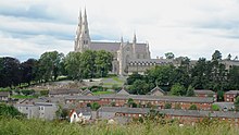
|
14,777 (2011)[13] |
| Bangor1 | time immemorial | Cathedral Church of St Deiniol | Community |
Wales | 
|
18,808 (2011)[14] |
| Bath1 | 1090 | Abbey Church of SS Peter & Paul4 | Charter trustees |
South West, England | 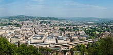
|
88,859 (2011)[15] 97,311 (urban area, 2010)[16] |
| Belfast (Irish: Béal Feirste) (Ulster-Scots: Bilfawst) |
1888 | not applicable | Local government district |
Northern Ireland | 
|
333,871 (2011)[17] |
| Birmingham2 | 188933 | not applicable | Local government district (Metropolitan borough) |
West Midlands, England | 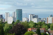
|
1,092,330 (2013)[18] |
| Bradford1 | 1897 | not applicable | Local government district (Metropolitan borough) |
Yorkshire and the Humber, England | 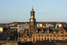
|
522,452 (2011)[19] |
| Brighton & Hove15 | 2000 | not applicable | Local government district (Unitary) |
South East, England | 
|
273,369 (2011)[19] |
| Bristol1 | 1542 | Cathedral Church of the Holy & Undivided Trinity | Local government district (Unitary and county) |
South West, England | 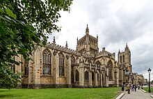
|
428,234 (2011)[19] |
| Cambridge3 | 195125 | not applicable | Local government district (Non-metropolitan borough) |
East, England | 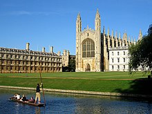
|
123,867 (2011)[19] |
| Canterbury3 | time immemorial | Cathedral & Metropolitical Church of Christ | Local government district (Non-metropolitan borough) |
South East, England | 
|
151,145 (2011)[19] |
| Cardiff9 (Welsh: Caerdydd) |
190529 | not applicable | Local government district (Principal area) |
Wales | 
|
346,090 (2011)[19] |
| Carlisle1 | 1133 | Cathedral Church of the Holy & Undivided Trinity | Local government district (Non-metropolitan borough) |
North West, England | 
|
107,524 (2011)[19] |
| Chelmsford37 | 2012 | not applicable | Local government district (Non-metropolitan borough) |
East, England | 
|
168,310 (2011)[19] |
| Chester3 | 1541 | Cathedral Church of Christ & the Blessed Virgin Mary | Charter trustees‡ |
North West, England | 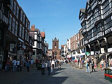
|
91,733 (urban area, 2010)[16] |
| Chichester1 | 1075 | Cathedral Church of the Holy Trinity | Civil parish |
South East, England | 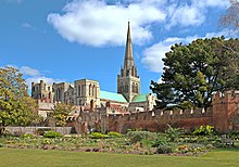
|
26,795 (2011)[20] |
| Coventry1 | 1102 | St Michael's Cathedral5 | Local government district (Metropolitan borough) |
West Midlands, England | 
|
316,915 (2011)[19] |
| Derby13 | 1977 | not applicable | Local government district (Unitary) |
East Midlands, England | 
|
248,752 (2011)[19] |
| Derry39 (Irish: Doire) (Ulster-Scots: Derrie) |
1604[21] | not applicable | None. Represented on Derry City and Strabane District Council |
Northern Ireland | 
|
107,877 (2011)[13] |
| Dundee32 (Scottish Gaelic: Dùn Dèagh) |
188930 (Burgh: 1191) |
not applicable | Local government district (Council area) |
Scotland | 
|
147,26838 |
| Durham1 | 995 | Cathedral Church of Christ, St Mary the Virgin and St Cuthbert | Charter trustees‡ |
North East, England | 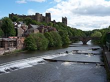
|
94,375 (2011)[22] |
| Edinburgh32 (Scottish Gaelic: Dùn Èideann) |
18th century[11] (Burgh: 1329) |
not applicable | Local government district (Council area) |
Scotland | 
|
476,62638 |
| Ely1 | 1109 | Cathedral Church of the Holy & Undivided Trinity | Civil parish |
East, England | 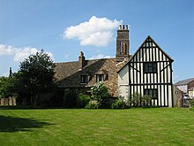
|
20,256 (2011)[23] |
| Exeter1 | time immemorial | Cathedral Church of St Peter | Local government district (Non-metropolitan borough) |
South West, England | 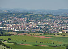
|
117,773 (2011)[19] |
| Glasgow32 (Scots: Glesga) (Scottish Gaelic: Glaschu) |
18th century[11] (Burgh: 1492) |
not applicable | Local government district (Council area) |
Scotland | 
|
593,24538 |
| Gloucester1 | 1541 | Cathedral Church of St Peter & the Holy and Indivisible Trinity | Local government district (Non-metropolitan borough) |
South West, England | 
|
121,688 (2011)[19] |
| Hereford119 | time immemorial | Cathedral Church of SS Mary the Virgin & Ethelbert the King | Civil parish |
West Midlands, England | 
|
58,896 (2011)[24] |
| Inverness (Scots: Inerness)(Scottish Gaelic: Inbhir Nis) |
2000 | not applicable | None |
Scotland | 
|
79,415[25] |
| Kingston upon Hull12 | 1897 | not applicable | Local government district (Unitary) |
Yorkshire and the Humber, England | 
|
256,406 (2011)[19] |
| Lancaster1 | 193726 | not applicable | Local government district (Non-metropolitan borough) |
North West, England | 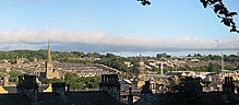
|
138,375 (2011)[19] |
| Leeds1 | 1893 | not applicable | Local government district (Metropolitan borough) |
Yorkshire and the Humber, England | 
|
751,485 (2011)[19] |
| Leicester1 | 191922 | not applicable | Local government district (Unitary) |
East Midlands, England | 
|
329,839 (2011)[19] |
| Lichfield17 | time immemorial | Cathedral Church of SS Mary & Chad | Civil parish |
West Midlands, England | 
|
32,219 (2011)[26] |
| Lincoln3 | 1072 | Cathedral Church of St Mary | Local government district (Non-metropolitan borough) |
East Midlands, England | 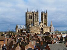
|
93,541 (2011)[19] |
| Lisburn (Irish: Lios na gCearrbhach) |
2002 | not applicable | None. Represented on Lisburn and Castlereagh City Council |
Northern Ireland | 
|
45,370 (2011)[13] |
| Liverpool2 | 1880 | Cathedral Church of Christ | Local government district (Metropolitan borough) |
North West, England | 
|
466,415 (2011)[19] |
| City of London6 | time immemorial | St Paul's Cathedral | Local government district (sui generis and ceremonial county) |
London | 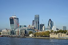
|
7,375 (2011)[19] |
| Manchester1 | 185334 | Manchester Cathedral | Local government district (Metropolitan borough) |
North West, England | 503,127 (2011)[19] | |
| Newcastle upon Tyne1 | 1882 | Cathedral Church of St Nicholas | Local government district (Metropolitan borough) |
North East, England | 
|
280,177 (2011)[19] |
| Newport14 (Welsh: Casnewydd) |
2002 | not applicable | Local government district (Principal area) |
Wales | 
|
145,736 (2011)[19] |
| Newry (Irish: Iúr Cinn Trá) (Ulster-Scots: Newrie) |
2002 | not applicable | None. Represented on Newry, Mourne and Down District Council |
Northern Ireland | 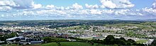
|
29,946 (2008, settlement population)[27] |
| Norwich1 | 1094 | Cathedral Church of the Holy & Undivided Trinity | Local government district (Non-metropolitan borough) |
East, England | 
|
132,512 (2011)[19] |
| Nottingham1 | 1897 | not applicable | Local government district (Unitary) |
East Midlands, England | 
|
305,680 (2011)[19] |
| Oxford1 | 1542 | Cathedral Church of Christ | Local government district (Non-metropolitan borough) |
South East, England | 
|
151,906 (2011)[19] |
| Perth (Scots: Pairth) (Scottish Gaelic: Peairt) |
2012[28] (Burgh: 12th century)[30] |
not applicable | None |
Scotland | 
|
45,77038 |
| Peterborough2 | 1541 | Cathedral Church of St Peter, St Paul, & St Andrew | Local government district (Unitary) |
East, England | 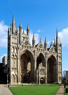
|
183,631 (2011)[19] |
| Plymouth1 | 192827 | not applicable | Local government district (Unitary) |
South West, England | 
|
256,384 (2011)[19] |
| Portsmouth1 | 192624 | not applicable | Local government district (Unitary) |
South East, England | 
|
205,056 (2011)[19] |
| Preston14 | 2002 | not applicable | Local government district (Non-metropolitan borough) |
North West, England | 
|
140,202 (2011)[19] |
| Ripon1 | 886 | Cathedral Church of SS Peter & Wilfrid | Civil parish |
Yorkshire and the Humber, England | 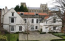
|
16,702 (2011)[31] |
| St Albans7 | 187736 | Cathedral & Abbey Church of St Alban | Local government district (Non-metropolitan borough) |
East, England | 
|
140,644 (2011)[19] |
| St Asaph37 (Welsh: Llanelwy) |
2012 | not applicable | Community |
Wales | 
|
3,355 (2011)[32] |
| St Davids20 (Welsh: Tyddewi) |
1994 | St Davids | Community |
Wales | 
|
1,841 (2011)[33] |
| Salford1 | 192624 | not applicable | Local government district (Metropolitan borough) |
North West, England | 
|
233,933 (2011)[19] |
| Salisbury35 | 1227 | Cathedral Church of St Mary | Civil parish‡ |
South West, England | 
|
40,302 (2011)[34] |
| Sheffield3 | 1893 | not applicable | Local government district (Metropolitan borough) |
Yorkshire and the Humber, England | 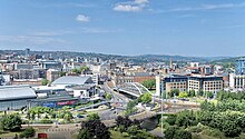
|
552,698 (2011)[19] |
| Southampton1 | 1964 | not applicable | Local government district (Unitary) |
South East, England | 
|
236,882 (2011)[19] |
| Stirling (Scots: Stirlin) (Scottish Gaelic: Sruighlea) |
2002 | not applicable | None |
Scotland | 
|
34,79038 |
| Stoke-on-Trent3 | 192528 | not applicable | Local government district (Unitary) |
West Midlands, England | 
|
249,008 (2011)[19] |
| Sunderland18 | 1992 | not applicable | Local government district (Metropolitan borough) |
North East, England | 
|
275,506 (2011)[19] |
| Swansea9 (Welsh: Abertawe) |
196923 | not applicable | Local government district (Principal area) |
Wales | 
|
239,023 (2011)[19] |
| Truro1 (Cornish: Truru) |
1877 | Cathedral Church of St Mary | Civil parish |
South West, England | 
|
18,766 (2011)[35] |
| Wakefield3 | 1888 | Cathedral Church of All Saints | Local government district (Metropolitan borough) |
Yorkshire and the Humber, England | 
|
325,837 (2011)[19] |
| Wells1 | time immemorial | Cathedral Church of St Andrew | Civil parish |
South West, England | 
|
10,536 (2011)[36] |
| Westminster21 | 1540 | Westminster Abbey4 (Although this was only a cathedral for 10 years until 1550, the city did not lose its status) | Local government district (London borough) |
London | 
|
219,396 (2011)[19] |
| Winchester1 | time immemorial | Cathedral Church of the Holy Trinity | Local government district (Non-metropolitan borough) |
South East, England | 
|
116,595 (2011)[19] |
| Wolverhampton16 | 2000 | not applicable | Local government district (Metropolitan borough) |
West Midlands, England | 
|
249,470 (2011)[19] |
| Worcester3 | time immemorial | Cathedral Church of Christ & St Mary | Local government district (Non-metropolitan borough) |
West Midlands, England | 
|
98,768 (2011)[19] |
| York1,8 | time immemorial | Cathedral & Metropolitical Church of St Peter | Local government district (Unitary) |
Yorkshire and the Humber, England | 
|
198,051 (2011)[19] |
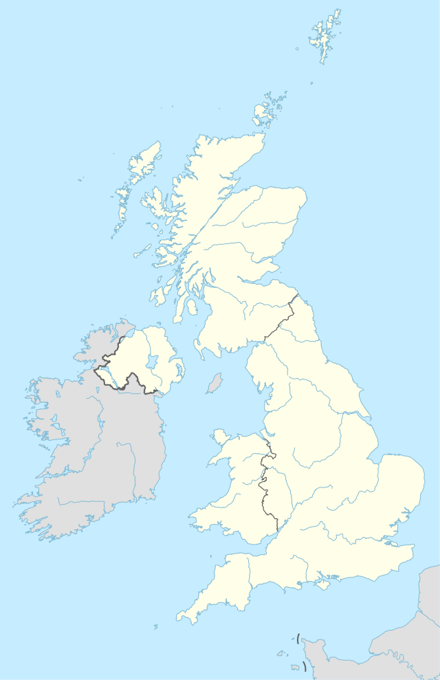
Map of the cities[]
British Overseas Territories[]
There are a number of cities in the British Overseas Territories, such as the City of James Town on Saint Helena.[37]
See also[]
- City status in the United Kingdom
- Centre for Cities
- List of lord mayoralties and lord provostships in the United Kingdom
- List of towns in the United Kingdom
- List of urban areas in the United Kingdom
- List of cities in Ireland
- List of smallest cities in the United Kingdom
- List of royal burghs of Scotland
Notes[]
- ^‡ The status bearers of these cities changed on 1 April 2009 due to local government reforms. Salisbury became a civil parish, while charter trustees were formed for the former district council areas of Chester and Durham in the new unitary authorities of Cheshire West and Chester and County Durham respectively.[38][39]
- ^1 City status confirmed by Letters Patent issued under the Great Seal dated 1 April 1974.[40]
- ^2 City status confirmed by Letters Patent issued under the Great Seal dated 25 June 1974.[41]
- ^3 City status confirmed by Letters Patent issued under the Great Seal dated 28 May 1974.[42]
- ^4 Bath Abbey and Westminster Abbey are no longer cathedrals.
- ^5 Coventry has had three cathedrals: the first, St Mary's, from 1043 to 1539 (it became a cathedral in 1102); the second, St Michael's, from 1918 to 1940, when it was destroyed by German bombardment; and its replacement, also St Michael's, built alongside the old cathedral, consecrated in 1962.
- ^6 Note that the City of London covers only the "square mile", and is usually just referred to as "the City". The larger conurbation of Greater London has no city charter, and consists of the City of London, the City of Westminster and 31 other London boroughs. This can be compared to the City of Brussels, within Brussels.
- ^7 City status was confirmed by Letters Patent dated 9 July 1974.[43] The city status extends to the entire district, although the district council calls itself "St Albans District Council" or "St Albans City and District".
- ^8 Letters Patent under the Great Seal conferring City Status were issued to the unitary authority of York on 1 April 1996, confirming the right of the Lord Mayor to be styled "Right Honourable", in continuation to those granted to the previous City Council abolished 31 March 1996.[44]
- ^9 Letters Patent under the Great Seal were issued on 29 March 1996 ordaining that the counties of Swansea and Cardiff should have the status of cities from 1 April 1996. The counties replaced the previous district councils which had enjoyed city status.[44]
- ^10 According to the Municipal Year Book, 1972 the royal burghs of Perth and Elgin officially enjoyed city status. The royal burghs of Brechin, Dunfermline and Kirkwall had also been officially described as "cities". As all burghs were abolished in 1975, these areas are now often called "former cities". Although Brechin does not have city status, the community council formed for the area uses the title "City of Brechin and District".
- ^11 Armagh had previously enjoyed city status, with St Patrick's Cathedral the seat of the metropolitan primate of all Ireland. The city status was lost in 1840 when the city corporation was abolished. However, the successor urban district council and district council frequently used the title of city without official sanction prior to 1994.
- ^12 City Status confirmed by Letters Patent issued under the Great Seal dated 18 March 1975.[45]
- ^13 City status granted by Letters Patent dated 7 June 1977.[46]
- ^14 City status granted to the "Town of Newport in the County Borough of Newport" and the "Town of Preston" by Letters Patent dated 15 May 2002.[47]
- ^15 Letters Patent dated 31 January 2001 ordained that "the Towns of Brighton and Hove shall have the status of a City".[48]
- ^16 Letters Patent dated 31 January 2001 ordained that "the Town of Wolverhampton shall have the status of a City".[48]
- ^17 Letters Patent dated 4 November 1980 ordained that the "Town of Lichfield shall have the status of a City". A town council had been constituted in 1980 leading to the dissolution of the Charter Trustees of the City of Lichfield.[49][50]
- ^18 City status granted by Letters Patent dated 23 March 1992.[51]
- ^19 City status was conferred on Hereford Town Council 11 October 2000.[52] The status had previously been confirmed to the district council formed in 1974. When that council was abolished in 1996 charter trustees were formed for the City of Hereford. On the formation of a town council for Hereford in April 2000 the charter trustees were dissolved, and the city status temporarily lapsed.
- ^20 St David's historically had city status because of the presence of St David's Cathedral. In 1849 it was noted that the city had no municipal corporation: There was however a recognised "city" in which a mayor had limited jurisdiction.[53] A Royal Commission appointed in 1876 reported that the corporation had long been extinct, and the city was formally abolished in 1886 under the provisions of the Municipal Corporations Act 1883.[54] Letters Patent dated 16 September 1994 ordained that the "Town of St. David's shall have the status of a City".[55]
- ^21 The title of City was used "by courtesy" after 1550 when Westminster ceased to be the see of a bishop. By Letters Patent dated 27 October 1900 city status was conferred on the newly created Metropolitan Borough of Westminster from 1 November.[56] This status was continued on the creation of the City of Westminster as a London borough in 1965.
- ^22 A letter from the Home Secretary to the Mayor of Leicester dated 14 June 1919, confirming that the city status would be bestowed, noted that this was a "restoration to your ancient town of its former status of a city".[57][58][59]
- ^23 Letters Patent dated 10 December 1969.[60]
- ^24 Letters Patent dated 21 April 1926.[61]
- ^25 Letters Patent dated 21 March 1951.[62]
- ^26 Letters Patent dated 14 May 1937.[63]
- ^27 Letters Patent dated 18 October 1928.[64]
- ^28 Letters Patent dated 5 June 1925.[65]
- ^29 Letters Patent dated 28 October 1905, which also granted the title of Lord Mayor.[66]
- ^30 Warrant issued 28 January 1889 that Letters Patent be issued under the Seal appointed by the treaty of union to be used in place of the Great Seal of Scotland, ordaining and declaring that the Burgh of Dundee shall be a City, and shall be called and styled "The City of Dundee".[67]
- ^31 Burghs of Old Aberdeen and Woodside and the district of Torry incorporated as the City and Royal Burgh of Aberdeen by the Aberdeen Corporation Act 1891 (54 & 55 Vict. c. cxxiv).
- ^32 The present council areas are designated "cities" by virtue of the Local Government etc. (Scotland) Act 1994, which also reserves the post of Lord Provost for the convener of the four councils. The previous local government districts and district councils created by the Local Government (Scotland) Act 1973 enjoyed the same privileges.
- ^33 Letters Patent dated 14 January 1889.[68]
- ^34 Letters Patent dated 29 March 1853.[69]
- ^35 Letters Patent dated 1 April 2009.[70] City status had been held prior to this date (and since 1974) by the Charter Trustees of the City of New Sarum. The city of Salisbury's formal name was New Sarum (see also: Old Sarum) from 1227 until 2009.
- ^36 Letters Patent dated 28 August 1877.[71]
- ^37 Letters Patent dated 1 June 2012 "to ordain that the Town of Chelmsford in the County of Essex and the Town of St Asaph in the County of Denbighshire shall have the status of a City".[72]
- ^38 [2015] Localities (Glasgow)[73]
- ^39 Legally, the city and county are called "Londonderry", while the local government district is called "Derry". See Derry/Londonderry name dispute.[74]
References[]
- ^ Jump up to: a b c Department for Culture, Media and Sport. "Civic Honours Competition: UK Cities". The National Archives (United Kingdom), 18 January 2011. Accessed 17 December 2018.
- ^ Jump up to: a b c Beckett (2005).
- ^ "JTK". "Civitas" in Celtic Culture: A Historical Encyclopedia, Vol. I, p. 451. ABC-CLIO (Sta. Barbara), 2006.
- ^ De Excidio Britanniae, §3. (in Latin) Cited in the "Civitas" entry of Celtic Culture.[3]
- ^ Nennius (attrib.). Theodor Mommsen (ed.). Historia Brittonum, VI. Composed after AD 830. (in Latin) Hosted at Latin Wikisource.
- ^ Encyclopædia Britannica, 11th ed. 1911.
- ^ The 11th edition of the Encyclopædia Britannica, for instance, listed St Asaph and Southwell as cities on the basis of their cathedrals despite their lack of charters or, in Southwell's case, local government.[6]
- ^ Beckett (2005), p. 22.
- ^ "ASA Adjudication on Medway Council". Asa.org.uk. 16 March 2011. Retrieved 9 June 2016.
- ^ Kingdoms of England and Scotland. "Act of Union", §XXI. 16 January 1707.
- ^ Jump up to: a b c d Beckett, J.V. City Status in the British Isles, 1830–2002, pp. 16 ff. Ashgate Publishing, 2005.
- ^ Clark, M. Lynda & al. "Committee on Privileges Second Report", Appendix 3, ss58. Parliament of the United Kingdom (London), 1999.
- ^ Jump up to: a b c "Usual Resident Population: KS101NI (administrative geographies)". Census 2011. Northern Ireland Statistics and Research Agency. Retrieved 4 October 2013.
- ^ Office for National Statistics 2011 census – Bangor C
- ^ "Bath". BANES 2011 Census Ward Profiles. Retrieved 13 March 2015. (Combined populations of the 16 wards that make-up the city.)
- ^ Jump up to: a b "Mid 2010 Urban Area Estimates England and Wales". Office for National Statistics. 4 September 2012. Retrieved 7 April 2014.
- ^ "Usual Resident Population: KS101NI (administrative geographies)". Census 2011. Northern Ireland Statistics and Research Agency. Retrieved 13 June 2015.
- ^ "UK Population Estimates" Archived 10 August 2014 at the Wayback Machine. (ONS). Retrieved 28 June 2014
- ^ Jump up to: a b c d e f g h i j k l m n o p q r s t u v w x y z aa ab ac ad ae af ag ah ai aj ak al am an ao ap "2011 Census: KS101EW Usual resident population, local authorities in England and Wales". Office for National Statistics. Retrieved 8 January 2013.
- ^ Office for National Statistics 2011 census – Chichester CP
- ^ City commemorates the 400th Anniversary of the City’s first charter, Derry City Council press release dated 7 July 2004, (accessed 15 December 2007) Archived 2 June 2008 at the Wayback Machine
- ^ City status extends to the area of the former District of Durham "Charter trust and Mayor for Durham City". Durham County Council. Archived from the original on 6 January 2014. Retrieved 2 February 2013. "2011 Census Statistical Profile". Durham County Council. Retrieved 2 February 2013.[permanent dead link]
- ^ Office for National Statistics 2011 census – Ely (Cambs) CP
- ^ "2011 Census: Usual resident population estimates by broad age group for Wards & Market Towns in Herefordshire". Herefordshire Council. Archived from the original on 26 October 2011. Retrieved 8 January 2013.
- ^ "Highland Profile". Highland Council.
- ^ Office for National Statistics 2011 census – Lichfield CP
- ^ "Home".
- ^ Letters Patent dated 21 May 2012 "News: The National Records of Scotland seals Perth's city status". National Archives of Scotland. 6 July 2012. "'We really feel part of history being made' — Letters Patent makes Perth's city status official". The Courier (Dundee). 5 July 2012. Archived from the original on 9 July 2012. Retrieved 5 July 2012.
- ^ A A M Duncan (24 March 1973). "Perth. The First Century of the Burgh" (PDF). Transactions of the Perthshire Society of Natural Science. Archived from the original (PDF) on 24 December 2013.
- ^ Created a royal burgh at some point under King David I (1124–53) although the earliest surviving charters date to 1209 or 1210; the status was abolished in 1975.[11][29]
- ^ Office for National Statistics 2011 census – Ripon CP
- ^ Office for National Statistics 2011 census – St. Asaph C
- ^ Office for National Statistics 2011 census – St. David's and the Cathedral Close C
- ^ Office for National Statistics 2011 census – Salisbury CP
- ^ Office for National Statistics 2011 census – Truro CP
- ^ "Wells CP – Usual Resident Population, 2011". Neighbourhood Statistics. Office for National Statistics. Retrieved 24 December 2014.
- ^ The Government of the United Kingdom. "The St Helena, Ascension, and Tristan da Cunha Constitution Order 2009". The National Archives of the United Kingdom (London), 2009.
- ^ "Local Government (Structural Changes) (Miscellaneous Amendments and Other Provision) Order 2009". Tow. Office of Public Sector Information. 2009. Retrieved 27 February 2009.
- ^ "New Parish Council for the City of Salisbury". Towards One Council. Wiltshire County Council. Retrieved 11 August 2021.
- ^ "No. 46255". The London Gazette. 4 April 1974. p. 4400.
- ^ "No. 46303". The London Gazette. 28 June 1974. pp. 6485–6486.
- ^ "No. 46303". The London Gazette. 31 May 1974. p. 6485.
- ^ "No. 46352". The London Gazette. 24 September 1974. p. 7920.
- ^ Jump up to: a b "No. 54363". The London Gazette. 4 April 1996. p. 4925.
- ^ "No. 46522". The London Gazette. 20 March 1975. p. 3729.
- ^ "No. 47246". The London Gazette. 14 June 1977. p. 7656.
- ^ "No. 56573". The London Gazette. 21 May 2002. p. 6160.
- ^ Jump up to: a b "No. 56109". The London Gazette. 2 May 2001. p. 1431.
- ^ "No. 48364". The London Gazette. 7 November 1980. p. 15451.
- ^ "Lichfield City Council website". Archived from the original on 27 September 2011.
- ^ "No. 52874". The London Gazette. 26 March 1992. p. 5413.
- ^ Charters of Hereford City Council Archived 6 July 2008 at the Wayback Machine
- ^ Lewis, Samuel (1849). ""Dale – St. David's"". A Topographical Dictionary of Wales. London: British History Online. pp. 278–288. Retrieved 7 July 2020.
- ^ 46 & 47 Vict. c. 18, s.3 and Sch. II (Part I)
- ^ "No. 53798". The London Gazette. 23 September 1994. p. 13403.
- ^ "No. 27242". The London Gazette. 30 October 1900. p. 6613.
- ^ The Times: Leicester, a City: Sequel to the Recent Royal Visit, 17 June 1919
- ^ "Civic history: The making of a City, (Leicester City Council), accessed 14 February 2008". Archived from the original on 23 March 2008.
- ^ Leicester: The Dignity of a City 655–1926, Leicester's city status, its loss and its regaining over thirteen centuries by Daniel Williams
- ^ "No. 44986". The London Gazette. 12 December 1969. p. 12450.
- ^ "No. 33154". The London Gazette. 23 April 1926. pp. 2776–2777.
- ^ "No. 39201". The London Gazette. 13 April 1951. p. 2067.
- ^ "No. 34400". The London Gazette. 21 May 1937. p. 3296.
- ^ "No. 33433". The London Gazette. 26 October 1928. p. 6850.
- ^ "No. 33063". The London Gazette. 3 July 1925. p. 4449.
- ^ "No. 27849". The London Gazette. 31 October 1905. p. 7249.
- ^ London Gazette, 29 January 1889
- ^ From the London Gazette, 18 January 1889, The Times, 19 January 1889
- ^ "No. 21426". The London Gazette. 1 April 1853. p. 950.
- ^ "No. 59250". The London Gazette. 24 November 2009. p. 20329.
- ^ "No. 24502". The London Gazette. 11 September 1877. p. 5185.
to ordain and declare that the Borough of Saint Albans, in the county of Hertford, shall be a City, and shall be called and styled 'The City of Saint Albans, in the county of Hertford.'
- ^ "No. 60167". The London Gazette. 11 June 2012. p. 11125.
- ^ "Scotland (United Kingdom): Council Areas & Localities – Population Statistics, Charts and Map". citypopulation.de.
- ^ Application by Derry City Council for judicial review [2007] NIQB 5 Ref WEAF5707
| show |
|---|
- Cities in the United Kingdom
- Lists of cities by country
- Lists of cities in Europe
- Lists of cities in the United Kingdom
- United Kingdom geography-related lists