List of Welsh principal areas
| This article is part of a series within UK politics on the |
| Politics of Wales |
|---|
Category ·
|
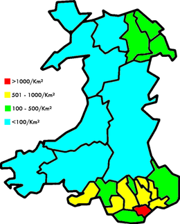
Population in Wales is concentrated in the South Wales Valleys and the northeast; the remainder of the country is sparsely populated
This is a list of the 22 principal areas of Wales[1][2] giving their most recent date of creation and the style by which they are known.
The population, density and areas are estimates for 2019 from the Office for National Statistics.[3]
| District | Created | Population | Population
density/km2 |
Area km2 | Type |
|---|---|---|---|---|---|
| Cardiff | 1996 a | 369,202 | 2,585 | 140 | County (also a city) |
| Swansea | 1996 a | 246,563 | 649 | 378 | County (also a city) |
| Rhondda Cynon Taf | 1996 | 241,873 | 566 | 424 | County borough |
| Carmarthenshire | 1996 a | 190,073 | 79 | 2,370[4] | County |
| Caerphilly | 1996 | 181,731 | 653 | 278 | County borough |
| Flintshire | 1996 ab | 156,847 | 356 | 438 | County |
| Newport | 1996 a | 156,447 | 805 | 190 | County borough (also a city) |
| Bridgend | 1996 | 147,539 | 578 | 246 | County borough |
| Neath Port Talbot † | 1996 | 144,386 | 324 | 442 | County borough |
| Wrexham | 1996 | 136,055 | 270 | 498 | County borough |
| Vale of Glamorgan | 1996 | 135,295 | 399 | 335 | County borough |
| Powys | 1974 | 133,030 | 26 | 5,180[5] | County |
| Pembrokeshire | 1996 a | 126,751 | 77 | 1,590 | County |
| Gwynedd * | 1974 b | 125,171 | 49 | 2,535[6] | County |
| Conwy ‡ | 1996 | 118,184 | 104 | 1,130 | County borough |
| Denbighshire | 1996 ab | 96,664 | 114 | 844 | County |
| Monmouthshire | 1996 ab | 95,164 | 111 | 850 | County |
| Torfaen | 1996 | 94,832 | 740 | 126 | County borough |
| Ceredigion § | 1996 | 72,895 | 41 | 1,795 | County |
| Isle of Anglesey | 1996 a | 70,440 | 98 | 714 | County |
| Blaenau Gwent | 1996 | 70,020 | 641 | 109 | County borough |
| Merthyr Tydfil | 1996 a | 60,424 | 540 | 111 | County borough |
* = Named as 'Caernarfonshire and Merionethshire' in legislation. Named changed by the council.
† = Named as 'Neath and Port Talbot' in legislation. Named changed by the council.
‡ = Named as 'Aberconwy and Colwyn' in legislation. Named changed by the council.
§ = Named as 'Cardiganshire' in legislation. Named changed by the council.
a = re-instated as a principal administrative authority after a gap
b = boundaries significantly altered in 1996 from its previous incarnation
See also[]
References[]
- ^ "Welsh Local Authority Links - WLGA". www.wlga.wales. Retrieved 2020-06-10.
- ^ "Local Government (Wales) Act 1994 - Schedule 1: The New Principal Areas". Legislation.gov.uk. The National Archives. 5 July 1994. Retrieved 2020-11-26.
- ^ "Population Estimates for UK, England and Wales, Scotland and Northern Ireland, Mid-2019". Office for National Statistics. 6 May 2020. Retrieved 6 May 2020.
- ^ "Carmarthenshire - Population Density (QS102EW)". UKCensusdata.com. Retrieved 2018-06-18.
- ^ "Powys - Population Density (QS102EW)". UKCensusdata.com. Retrieved 2018-06-18.
- ^ "Gwynedd - Population Density (QS102EW)". UKCensusdata.com. Retrieved 2018-06-18.
| United Kingdom |
|
|---|---|
| England |
|
| Wales |
|
| Scotland |
|
| Northern Ireland |
|
Categories:
- Principal areas of Wales
- Wales geography-related lists