Monmouthshire
County of Monmouthshire
Sir Fynwy | |
|---|---|
 Coat of arms | |
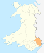
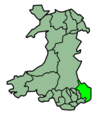
 Location within Wales | |
| Coordinates: 51°47′N 2°52′W / 51.783°N 2.867°WCoordinates: 51°47′N 2°52′W / 51.783°N 2.867°W | |
| Admin HQ | Usk |
| Largest town | Abergavenny |
| Government | |
| • MP | David Davies |
| • MS | Peter Fox |
| • Leader of Monmouthshire Council | Peter Fox |
| Area | |
| • Total | 850 km2 (330 sq mi) |
| Area rank | Ranked 7th |
| Population (2017) | |
| • Total | 94,590 |
| • Rank | Ranked 17th |
| • Density | 111/km2 (290/sq mi) |
| • Density rank | Ranked 15th |
| Ethnicity | |
| • White | 97.5% |
| Welsh language | |
| • Rank | 22nd |
| • Any skills | 12.9% |
| Time zone | GMT |
| • Summer (DST) | UTC+1 (BST) |
| ISO 3166 code | GB-MON |
| ONS code | 00PP (ONS) W06000021 (GSS) |

Monmouthshire (Welsh: Sir Fynwy) is a principal area in Wales. The name derives from the historic county of Monmouthshire of which it covers the eastern three-fifths. The largest town is Abergavenny. Other towns and large villages are Caldicot, Chepstow, Monmouth, Magor and Usk. It borders Torfaen, Newport and Blaenau Gwent to the west; Herefordshire and Gloucestershire to the east; and Powys to the north.
Historic county[]
The historic county of Monmouthshire was formed from the Welsh Marches by the Laws in Wales Act 1535 bordering Gloucestershire to the east, Herefordshire to the northeast, Brecknockshire to the north, and Glamorgan to the west. The Laws in Wales Act 1542 enumerated the counties of Wales and omitted Monmouthshire, implying that the county was no longer to be treated as part of Wales. However, for all purposes Wales had become part of the Kingdom of England, and the difference had little practical effect.
For several centuries, acts of the Parliament of England (in which Wales was represented) often referred to "Wales and Monmouthshire". However, the Local Government Act 1972, which came into effect in April 1974, confirmed the county as part of Wales, with the administrative county of Monmouthshire and its associated lieutenancy being abolished. Most of its area was transferred to a new local government and ceremonial county called Gwent, with the same eastern and southern boundaries as the historic county, the River Wye and the Severn Estuary. The western two-fifths are now administered by other principal areas: Blaenau Gwent, Torfaen, Caerphilly, and Newport.
Principal area[]
The current unitary authority of Monmouthshire was created on 1 April 1996 as a successor to the district of Monmouth along with the Llanelly community from Blaenau Gwent, both of which were districts of Gwent. The use of the name "Monmouthshire" rather than "Monmouth" for the area was controversial, being supported by the MP for Monmouth, Roger Evans, but being opposed by Paul Murphy, MP for Torfaen (inside the historic county of Monmouthshire but being reconstituted as a separate unitary authority).[1] By area it covers some 60% of the historic county, but only 20% of the population. A new council headquarters building at the site of Coleg Gwent, Usk was proposed and developed.[2] Planning permission was granted in September 2011.[3] The new county hall in Usk was opened in 2013.[4][5]
Under the Local Government (Wales) Act 1994, Monmouthshire is styled as a County.[6]
In comparison to the pre-1974 areas it covers:
- the former boroughs of Abergavenny and Monmouth
- the former urban districts of Chepstow and Usk
- the former rural districts of Abergavenny Rural District, Chepstow and Monmouth Rural District
- the former rural district of Pontypool, except the community of Llanfrechfa Lower
- the parish of Llanelly from the former Crickhowell Rural District in Brecknockshire
Places of interest[]

- Chepstow Castle[7]
- Raglan Castle[8]
- Monmouth[9]
- Trellech[10]
- Abergavenny Castle[11]
- Wye Valley[12]
- Black Mountains[13]
- Brecon Beacons National Park[14]
- White Castle[15]
- Skenfrith Castle[16]
- Grosmont Castle[17]
- Three Castles Walk[18]
- Offa's Dyke[19]
- Llanthony Priory[20]
- Tintern Abbey[21]
- Usk[22]
- Usk Valley Walk[23]
- Abergavenny[24]
- Monmouthshire and Brecon Canal[25]
- Marches Way[26]
- Monnow Valley Walk[27]
- Caldicot Castle[28]
- The Kymin[29]
- The Sugar Loaf[30]
Scenic Railway Line:
- Gloucester to Newport Line
Geography[]
Much of Monmouthshire is hilly, particularly the western area adjoining the industrial South Wales Valleys and the Black Mountains to the north. Two major river valleys dominate the lowlands - the scenic gorge of the Wye Valley along the border with Gloucestershire adjoining the Forest of Dean, and the valley of the River Usk between Abergavenny and Newport. Both rivers flow south to the Severn Estuary. The River Monnow is a tributary of the River Wye and forms part of the border with Herefordshire and England, passing through the town of Monmouth. The Black Mountains are part of the Brecon Beacons National Park, whilst the Wye Valley is a designated Area of Outstanding Natural Beauty (AONB) which straddles the England-Wales border.
The highest point (county top) of the county is Chwarel y Fan in the Black Mountains with a height of 679 metres (2,228 ft). The Sugar Loaf (Welsh: Mynydd Pen-y-fâl or Y Fâl), located three kilometres (two miles) northwest of Abergavenny, is probably the best known hill in the county. Although its height is only 596 metres (1,955 ft), its isolation and distinctive peak shape makes it a prominent landmark for many miles around.
References[]
- ^ Department of the Official Report (Hansard), House of Commons, Westminster. "Hansard, House of Commons, March 15, 1994, Column 782". Parliament.the-stationery-office.co.uk. Archived from the original on 10 February 2012. Retrieved 21 May 2011.CS1 maint: multiple names: authors list (link)
- ^ "Monmouthshire County Council press release, "This council is coming home", 12 January 2010". Monmouthshire.gov.uk. 12 January 2010. Archived from the original on 29 February 2012. Retrieved 21 May 2011.
- ^ "Plans for new Monmouthshire council HQ in Usk are approved". Free Press Series.
- ^ "Monmouthshire move into new HQ". Willmott Dixon.
- ^ Gabriel, Clare (18 April 2013). "'Agile working' office savings aim". Retrieved 21 March 2018 – via www.bbc.co.uk.
- ^ Local Government (Wales) Act 1994, Schedule 1. Retrieved 13 August 2021
- ^ "Chepstow Castle from the 1816 Bridge:: OS grid ST5394 :: Geograph Britain and Ireland - photograph every grid square!". Geograph.org.uk. Retrieved 21 May 2011.
- ^ "Raglan Castle:: OS grid SO4108 :: Geograph Britain and Ireland - photograph every grid square!". Geograph.org.uk. Retrieved 21 May 2011.
- ^ "Monnow Bridge, Monmouth:: OS grid SO5012 :: Geograph Britain and Ireland - photograph every grid square!". Geograph.org.uk. Retrieved 21 May 2011.
- ^ "Harold's Stones, Trellech:: OS grid SO4905 :: Geograph Britain and Ireland - photograph every grid square!". Geograph.org.uk. Retrieved 21 May 2011.
- ^ "Abergavenny Castle:: OS grid SO2913 :: Geograph Britain and Ireland - photograph every grid square!". Geograph.org.uk. Retrieved 21 May 2011.
- ^ "Wye Valley View from Eagle's Nest on Wynd Cliff:: OS grid ST5296 :: Geograph Britain and Ireland - photograph every grid square!". Geograph.org.uk. Retrieved 21 May 2011.
- ^ "The Sugar Loaf, near Abergavenny:: OS grid SO2718 :: Geograph Britain and Ireland - photograph every grid square!". Geograph.org.uk. Retrieved 21 May 2011.
- ^ "Looking NNE from the Sugar Loaf:: OS grid SO2620 :: Geograph Britain and Ireland - photograph every grid square!". Geograph.org.uk. Retrieved 21 May 2011.
- ^ "White Castle:: OS grid SO3716 :: Geograph Britain and Ireland - photograph every grid square!". Geograph.org.uk. Retrieved 21 May 2011.
- ^ "Skenfrith Castle:: OS grid SO4520 :: Geograph Britain and Ireland - photograph every grid square!". Geograph.org.uk. Retrieved 21 May 2011.
- ^ "Grosmont Castle:: OS grid SO4024 :: Geograph Britain and Ireland - photograph every grid square!". Geograph.org.uk. Retrieved 21 May 2011.
- ^ "The Three Castles Walk:: OS grid SO4421 :: Geograph Britain and Ireland - photograph every grid square!". Geograph.org.uk. Retrieved 21 May 2011.
- ^ "Devil's Pulpit:: OS grid ST5499 :: Geograph Britain and Ireland - photograph every grid square!". Geograph.org.uk. Retrieved 21 May 2011.
- ^ "Llanthony Priory:: OS grid SO2827 :: Geograph Britain and Ireland - photograph every grid square!". Geograph.org.uk. Retrieved 21 May 2011.
- ^ "Tintern Abbey:: OS grid SO5300 :: Geograph Britain and Ireland - photograph every grid square!". Geograph.org.uk. 30 March 2005. Retrieved 21 May 2011.
- ^ "View from Usk Castle:: OS grid SO3700 :: Geograph Britain and Ireland - photograph every grid square!". Geograph.org.uk. Retrieved 21 May 2011.
- ^ "Clytha Castle:: OS grid SO3608 :: Geograph Britain and Ireland - photograph every grid square!". Geograph.org.uk. Retrieved 21 May 2011.
- ^ "Market Hall clock tower, Abergavenny:: OS grid SO2914 :: Geograph Britain and Ireland - photograph every grid square!". Geograph.org.uk. Retrieved 21 May 2011.
- ^ "Monmouthshire & Brecon Canal, Govilon:: OS grid SO2713 :: Geograph Britain and Ireland - photograph every grid square!". Geograph.org.uk. Retrieved 21 May 2011.
- ^ "Stream at Dolydd y Castell, Abergavenny:: OS grid SO3013 :: Geograph Britain and Ireland - photograph every grid square!". Geograph.org.uk. 1 April 2007. Retrieved 21 May 2011.
- ^ "The Monnow Valley:: OS grid SO4323 :: Geograph Britain and Ireland - photograph every grid square!". Geograph.org.uk. Retrieved 21 May 2011.
- ^ "Caldicot Castle:: OS grid ST4888 :: Geograph Britain and Ireland - photograph every grid square!". Geograph.org.uk. Retrieved 21 May 2011.
- ^ "The Round House, The Kymin, Monmouth:: OS grid SO5212 :: Geograph Britain and Ireland - photograph every grid square!". Geograph.org.uk. Retrieved 21 May 2011.
- ^ "Sugar Loaf and Usk Valley". National Trust.
External links[]
- Monmouthshire County Council
- Monmouthshire at Curlie
- The Original Monmouthshire website Monmouthshire.co.uk
- Genuki National Gazetteer of 1868
| show Transport in Monmouthshire |
|---|
| show Authority control |
|---|
- Monmouthshire
- Counties of Wales
- Principal areas of Wales