Spink Colony, South Dakota
Spink Colony, South Dakota | |
|---|---|
 Spink Colony | |
| Coordinates: 44°44′49″N 98°17′34″W / 44.74694°N 98.29278°WCoordinates: 44°44′49″N 98°17′34″W / 44.74694°N 98.29278°W | |
| Country | United States |
| State | South Dakota |
| County | Spink |
| Area | |
| • Total | 0.38 sq mi (0.98 km2) |
| • Land | 0.36 sq mi (0.92 km2) |
| • Water | 0.02 sq mi (0.06 km2) |
| Elevation | 1,278 ft (390 m) |
| Population (2020) | 135 |
| Time zone | UTC-6 (Central (CST)) |
| • Summer (DST) | UTC-5 (CDT) |
| ZIP Code | 57440 (Frankfort) |
| Area code(s) | 605 |
| FIPS code | 46-60180 |
| GNIS feature ID | 2813060[2] |


Spink Colony is a census-designated place (CDP) and Hutterite colony[3] in Spink County, South Dakota, United States. It was first listed as a CDP prior to the 2020 census.[2] The population of the CDP was 135 at the 2020 Census.[4]
It is in the southern part of the county, on the east side of the James River. It is 9 miles (14 km) south of Frankfort and 20 miles (32 km) by road southeast of Redfield, the county seat.
The Old Spink Colony, part of the CDP, was listed on the National Register of Historic Places in 1982.
References[]
- ^ "2020 U.S. Gazetteer Files – South Dakota". United States Census Bureau. Retrieved September 21, 2021.
- ^ a b "Spink Colony Census Designated Place". Geographic Names Information System. United States Geological Survey.
- ^ Friesen, Bert (May 2021). "Spink Hutterite Colony (Frankfort, South Dakota, USA)". Global Anabaptist Mennonite Encyclopedia Online. Retrieved September 20, 2021.
- ^ "U.S. Census Bureau: Spink Colony CDP, South Dakota". www.census.gov. United States Census Bureau. Retrieved 12 February 2022.
Municipalities and communities of Spink County, South Dakota, United States | ||
|---|---|---|
| Cities | 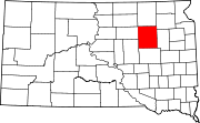 | |
| Towns | ||
| Townships | ||
| CDPs | ||
| Other communities | ||
| Footnotes | ‡This populated place also has portions in an adjacent county or counties | |
| ||
This South Dakota state location article is a stub. You can help Wikipedia by . |
Categories:
- Census-designated places in Spink County, South Dakota
- Census-designated places in South Dakota
- Hutterite communities
- South Dakota geography stubs