Spital am Pyhrn
Spital am Pyhrn | |
|---|---|
 | |
 Coat of arms | |
 Spital am Pyhrn Location within Austria | |
| Coordinates: 47°39′55″N 14°20′27″E / 47.66528°N 14.34083°ECoordinates: 47°39′55″N 14°20′27″E / 47.66528°N 14.34083°E | |
| Country | Austria |
| State | Upper Austria |
| District | Kirchdorf an der Krems |
| Government | |
| • Mayor | Aegidius Exenberger (SPÖ) |
| Area | |
| • Total | 108.89 km2 (42.04 sq mi) |
| Elevation | 640 m (2,100 ft) |
| Population (2018-01-01)[2] | |
| • Total | 2,238 |
| • Density | 21/km2 (53/sq mi) |
| Time zone | UTC+1 (CET) |
| • Summer (DST) | UTC+2 (CEST) |
| Postal code | 4582 |
| Area code | 07563 |
| Vehicle registration | KI |
| Website | www.spital-pyhrn.at |

Spital am Pyhrn is a municipality in the district of Kirchdorf an der Krems in the Austrian state of Upper Austria.
Geography[]
Spital lies in the Traunviertel. About 48 percent of the municipality is forest, and 19 percent is farmland.
View from Pacherkogel

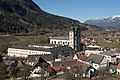
Former monastery in winter
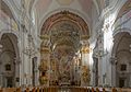
In the parish church
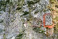
Engravings on rocks
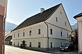
Former mansion of forgery
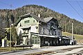
Railway station
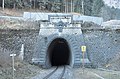
Northportal of railway tunnel Bosruck
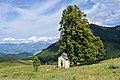
Chapel Ochsenwald

Arlingsattel - mountain pass
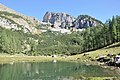
Lake Brunnsteiner

Alpine pasture Schmiedalm


References[]
- ^ "Dauersiedlungsraum der Gemeinden Politischen Bezirke und Bundesländer - Gebietsstand 1.1.2018". Statistics Austria. Retrieved 10 March 2019.
- ^ "Einwohnerzahl 1.1.2018 nach Gemeinden mit Status, Gebietsstand 1.1.2018". Statistics Austria. Retrieved 9 March 2019.
| Wikimedia Commons has media related to Spital am Pyhrn. |
| show Authority control |
|---|
This Upper Austria location article is a stub. You can help Wikipedia by . |
Categories:
- Cities and towns in Kirchdorf an der Krems District
- Upper Austria geography stubs