Squaretop Mountain
| Squaretop Mountain | |
|---|---|
 Squaretop Mountain, northwest aspect | |
| Highest point | |
| Elevation | 11,695 ft (3,565 m)[1] |
| Prominence | 655 ft (200 m)[1] |
| Parent peak | Peak 11830[2] |
| Isolation | 2.17 mi (3.49 km)[2] |
| Coordinates | 43°13′25″N 109°47′27″W / 43.22361°N 109.79083°WCoordinates: 43°13′25″N 109°47′27″W / 43.22361°N 109.79083°W[3] |
| Geography | |
 Squaretop Mountain Location in Wyoming | |
| Location | Sublette County, Wyoming, U.S. |
| Parent range | Wind River Range |
| Topo map | USGS Squaretop Mountain |
| Geology | |
| Type of rock | Migmatite[4] |
| Climbing | |
| First ascent | < 1921 by William Stroud[1] |
| Easiest route | class 2 hiking[2] SE ledges |


Squaretop Mountain is an 11,695-foot-elevation (3,565 meter) mountain summit located in Sublette County of Wyoming, United States.[3]
Geography[]
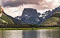
The peak is the emblematic geographical feature of the remote Wind River Range and is set seven miles west of the Continental Divide.[5] It is situated in the Bridger Wilderness on land managed by Bridger-Teton National Forest. Topographic relief is significant as the northeast aspect rises 3,700 feet (1,128 meters) above the Green River in one-half mile. The iconic view of Squaretop and Green River Lakes has been on the Wyoming licence plate since 2016.
Climate[]
According to the Köppen climate classification system, Squaretop Mountain is located in an alpine subarctic climate zone with long, cold, snowy winters, and cool to warm summers.[6] Due to its altitude, it receives precipitation all year, as snow in winter, and as thunderstorms in summer. Precipitation runoff from the mountain drains north into the Green River.
Climbing[]
The first ascent of Squaretop was made sometime before 1921 by William John Stroud (1854–1946), via the class 2 southeast ledges. Fred Beckey and Layton Kor climbed the Northeast Face in 1960.[7]
Other established climbing routes on Squaretop's walls:[8]
- West Gully – 1937 – class 3 – H. H. Bliss
- East Face Center – 1958 – (IV 5th) – Bill Byrd, Dave Dingman, Roland Wyatt
- North Buttress – 1960 – (III 5.7) – Ed Cooper, Ron Niccoli
- East Face Right – 1965 – (V 5.8) – Fred Beckey, Jerry Fuller
- Southeast Face – 1971 – (II 5.6) – Vince Lee, E. Park, M. Stephens, C. Zukowski
- West Couloir – 1972 – (II 5.5) – Vince Lee, Bo Beckham, Greg Smith
- West Face Dihedral – 1974 – (V 5.10) – Greg Lowe, Jeff Lowe, Kent Christensen
- East Face Left – 1984 – (V 5.10d) – Jeff Lowe, Renato Casarotto
- West Face Right – 1992 – (IV 5.9 A2) – Scott Cole, John Malken
- AC/DC – 1998 – (IV 5.10) – Andy Carson, Dan Carson
- Miscreant Line and Conveyor Belt (East Face) – 2001 – (V 5.10d) – Tod Anderson, Skyler Crane, James Donnell, Ernest Moskovics
- Marginally Orange – 2009 – (IV 5.10) Norm Goltra, Steve Walker
Hazards[]
Encountering bears is a concern in the Wind River Range.[9] There are other concerns as well, including bugs, wildfires, adverse snow conditions and nighttime cold temperatures.[10]
Importantly, there have been notable incidents, including accidental deaths, due to falls from steep cliffs (a misstep could be fatal in this class 4/5 terrain) and due to falling rocks, over the years, including 1993,[11] 2007 (involving an experienced NOLS leader),[12] 2015[13] and 2018.[14] Other incidents include a seriously injured backpacker being airlifted near Squaretop Mountain[15] in 2005,[16] and a fatal hiker incident (from an apparent accidental fall) in 2006 that involved state search and rescue.[17] The U.S. Forest Service does not offer updated aggregated records on the official number of fatalities in the Wind River Range.
Gallery[]
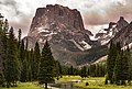

from Green River Lakes


from Green River Lakes with White Rock on left, "Tabletop" on right

from Green River Lakes
from Green River Lakes

2020 Wyoming license plate featuring Squaretop Mountain with Green River Lakes
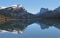
White Rock (left), Squaretop Mountain (right) reflected in Green River Lakes.
White Rock is a dolomite and limestone cliff that rises 3,300 feet above the lake.


See also[]
- List of mountain peaks of Wyoming
References[]
- ^ a b c "Squaretop Mountain, Wyoming". Peakbagger.com. Retrieved 2021-07-26.
- ^ a b c "Squaretop Mountain - 11,695' WY". listsofjohn.com. Retrieved 2021-07-26.
- ^ a b "Squaretop Mountain". Geographic Names Information System. United States Geological Survey. Retrieved July 26, 2021.
- ^ Joe Kelsey, 2013, Climbing and Hiking in the Wind River Mountains, Falcon Guides, ISBN 9781493001354, page 33.
- ^ Joe Kelsey, 2013, Climbing and Hiking in the Wind River Mountains, Falcon Guides, ISBN 9781493001354, page 37.
- ^ Peel, M. C.; Finlayson, B. L.; McMahon, T. A. (2007). "Updated world map of the Köppen−Geiger climate classification". Hydrol. Earth Syst. Sci. 11. ISSN 1027-5606.
- ^ Fred Beckey, 1961, North America, United States, Wyoming—Wind River Range, Northeast Face, Squaretop Americanalpineclub.org
- ^ Joe Kelsey, 2013, Climbing and Hiking in the Wind River Mountains, Falcon Guides, ISBN 9781493001354, pages 110–115, 419.
- ^ Staff (April 24, 2017). "Bear Safety in Wyoming's Wind River Country". WindRiver.org. Retrieved February 17, 2019.
- ^ Ballou, Dawn (July 27, 2005). "Wind River Range condition update - Fires, trails, bears, Continental Divide". PineDaleOnline News. Retrieved February 17, 2019.
- ^ Staff (1993). "Falling Rock, Loose Rock, Failure to Test Holds, Wyoming, Wind River Range, Seneca Lake". American Alpine Club. Retrieved February 15, 2019.
- ^ MacDonald, Dougald (August 14, 2007). "Trundled Rock Kills NOLS Leader". Climbing. Retrieved February 15, 2019.
- ^ Staff (December 9, 2015). "Officials rule Wind River Range climbing deaths accidental". Casper Star-Tribune. Retrieved February 15, 2019.
- ^ Dayton, Kelsey (August 24, 2018). "Deadly underestimation". WyoFile News. Retrieved February 15, 2019.
- ^ Funk, Jason (2009). "Squaretop Mountain Rock Climbing". Mountain Project. Retrieved March 29, 2019.
- ^ Staff (July 22, 2005). "Injured man rescued from Square Top Mtn - Tip-Top Search & Rescue helps 2 injured on the mountain". PineDaleOnline News. Retrieved February 17, 2019.
- ^ Staff (September 1, 2006). "Incident Reports - September, 2006 - Wind River Search". WildernessDoc.com. Retrieved February 17, 2019.
External links[]
- Squaretop Mountain rock climbing: Mountainproject.com
- Weather forecast: Squaretop Mountain
- Bridger–Teton National Forest
- Mountains of Sublette County, Wyoming
- Mountains of Wyoming
- North American 3000 m summits