Watch Tower (mountain)
| Watch Tower | |
|---|---|
 Watch Tower to left | |
| Highest point | |
| Elevation | 12,331 ft (3,758 m)[1] |
| Prominence | 246 ft (75 m)[1] |
| Coordinates | 42°46′27″N 109°14′04″W / 42.77417°N 109.23444°WCoordinates: 42°46′27″N 109°14′04″W / 42.77417°N 109.23444°W[2] |
| Geography | |
 Watch Tower Location in Wyoming | |
| Location | Fremont and Sublette Counties, Wyoming, U.S. |
| Parent range | Wind River Range |
| Topo map | USGS Lizard Head Peak |


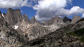
Watch Tower is a (12,331-foot (3,758 m)) mountain located in the southern Wind River Range in the U.S. state of Wyoming. Watch Tower is on the west side of the Cirque of the Towers, a popular climbing area and is just southeast of Block Tower.[3] Watch Tower is immediately east of the Continental Divide.
Hazards[]
Encountering bears is a concern in the Wind River Range.[4] There are other concerns as well, including bugs, wildfires, adverse snow conditions and nighttime cold temperatures.[5]
Importantly, there have been notable incidents, including accidental deaths, due to falls from steep cliffs (a misstep could be fatal in this class 4/5 terrain) and due to falling rocks, over the years, including 1993,[6] 2007 (involving an experienced NOLS leader),[7] 2015[8] and 2018.[9] Other incidents include a seriously injured backpacker being airlifted near Squaretop Mountain[10] in 2005,[11] and a fatal hiker incident (from an apparent accidental fall) in 2006 that involved state search and rescue.[12] The U.S. Forest Service does not offer updated aggregated records on the official number of fatalities in the Wind River Range.
References[]
- ^ a b "Watch Tower, Wyoming". Peakbagger.com. Retrieved March 23, 2014.
- ^ "Watch Tower". Geographic Names Information System. United States Geological Survey. Retrieved March 23, 2014.
- ^ Lizard Head Peak, WY (Map). TopoQwest (United States Geological Survey Maps). Retrieved March 23, 2014.
- ^ Staff (April 24, 2017). "Bear Safety in Wyoming's Wind River Country". WindRiver.org. Retrieved February 17, 2019.
- ^ Ballou, Dawn (July 27, 2005). "Wind River Range condition update - Fires, trails, bears, Continental Divide". PineDaleOnline News. Retrieved February 17, 2019.
- ^ Staff (1993). "Falling Rock, Loose Rock, Failure to Test Holds, Wyoming, Wind River Range, Seneca Lake". American Alpine Club. Retrieved February 15, 2019.
- ^ MacDonald, Dougald (August 14, 2007). "Trundled Rock Kills NOLS Leader". Climbing. Retrieved February 15, 2019.
- ^ Staff (December 9, 2015). "Officials rule Wind River Range climbing deaths accidental". Casper Star-Tribune. Retrieved February 15, 2019.
- ^ Dayton, Kelsey (August 24, 2018). "Deadly underestimation". WyoFile News. Retrieved February 15, 2019.
- ^ Funk, Jason (2009). "Squaretop Mountain Rock Climbing". Mountain Project. Retrieved March 29, 2019.
- ^ Staff (July 22, 2005). "Injured man rescued from Square Top Mtn - Tip-Top Search & Rescue helps 2 injured on the mountain". PineDaleOnline News. Retrieved February 17, 2019.
- ^ Staff (September 1, 2006). "Incident Reports - September, 2006 - Wind River Search". WildernessDoc.com. Retrieved February 17, 2019.
External links[]
| Wikimedia Commons has media related to Wind River Range. |
- General Information on the Wind River Range
- Climbing the Wind River Range (more)
- Glaciers in the Wind River Range
- Shoshone National Forest Federal website
- Continental Divide Trail information
Cheyenne (capital) | ||
| Topics |
|  Seal of Wyoming |
| Society |
| |
| Regions |
| |
| Cities |
| |
| Counties |
| |
This article about a location in Wyoming is a stub. You can help Wikipedia by . |
- Bridger–Teton National Forest
- Greater Yellowstone Ecosystem
- Landforms of Fremont County, Wyoming
- Mountain ranges of Wyoming
- Mountains of Fremont County, Wyoming
- Mountains of Wyoming
- Ranges of the Rocky Mountains
- Shoshone National Forest
- Wyoming geography stubs