Srinagar district
Srinagar District | |
|---|---|
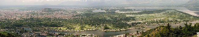
 Dal Lake | |
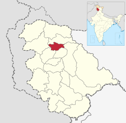 Map of Indian-administered Jammu and Kashmir with the Srinagar District highlighted red | |
| Coordinates: 34°05′N 74°50′E / 34.083°N 74.833°ECoordinates: 34°05′N 74°50′E / 34.083°N 74.833°E | |
| Country | |
| Union territory | Jammu and Kashmir |
| Headquarters | Srinagar |
| Tehsils |
|
| Government | |
| • District Magistrate | Mohammad Aijaz (IAS) |
| Area | |
| • Total | 1,979 km2 (764 sq mi) |
| Population (2011)[3] | |
| • Total | 1,250,173 |
| • Density | 630/km2 (1,600/sq mi) |
| Languages | |
| • Official | Kashmiri, Urdu, Hindi, Dogri, English[1][2] |
| Time zone | UTC+05:30 (IST) |
| Literacy | 69.41% |
| Website | http://srinagar.nic.in/ |

The Srinagar District is one of the 20 districts of the Indian-administered union territory of Jammu and Kashmir. Situated in the centre of the Kashmir Valley, it is the second-most populous district of the union territory after Jammu District as per the 2011 national census,[4] and is home to the summer capital city of Srinagar (with the city of Jammu serving as the territory's winter capital).[5] Likewise, the city of Srinagar also serves as the Srinagar District's headquarters.
Administration[]
Srinagar district has 2 Sub-Divisions i.e. Srinagar West and Srinagar East.
7 Tehsils are:
- Central Shalteng
- Chanapora/ Natipora
- Eidgah
- Khanyar
- Pantha chowk
- Srinagar North
- Srinagar South.
This district has 4 Blocks[6]
- Harwan
- Qammerwari
- Khonmoh
- Srinagar
These blocks consist of a number of panchayats and villages.
Politics[]
Srinagar District has 1 parliamentary constituency i.e. Srinagar and 8 assembly constituencies:
Demographics[]
According to the 2011 census Srinagar district has a population of 1,236,829,[4] roughly equal to the nation of Estonia[10] or the US state of New Hampshire.[11] This gives it a ranking of 381st in India (out of a total of 640).[4] The district has a population density of 703 inhabitants per square kilometre (1,820/sq mi).[4] Its population growth rate over the decade 2001–2011 was 20.35%.[4] Srinagar has a sex ratio of 900 females for every 1,000 males[4] (this varies with religion), and a literacy rate of 69.41%.[4]
| showSrinagar district: religion, gender ratio, and % urban of population, according to the 2011 Census.[8] |
|---|
At the time of the 2011 census, 94.13% of the population spoke Kashmiri and 1.88% Hindi as their first language.[9]
Weather[]
| hideClimate data for Srinagar (1971–1986) | |||||||||||||
|---|---|---|---|---|---|---|---|---|---|---|---|---|---|
| Month | Jan | Feb | Mar | Apr | May | Jun | Jul | Aug | Sep | Oct | Nov | Dec | Year |
| Average high °C (°F) | 7.0 (44.6) |
8.2 (46.8) |
14.1 (57.4) |
20.5 (68.9) |
24.5 (76.1) |
29.6 (85.3) |
30.1 (86.2) |
29.6 (85.3) |
27.4 (81.3) |
22.4 (72.3) |
15.1 (59.2) |
8.2 (46.8) |
19.7 (67.5) |
| Average low °C (°F) | −2 (28.4) |
−0.7 (30.7) |
3.4 (38.1) |
7.9 (46.2) |
10.8 (51.4) |
14.9 (58.8) |
18.1 (64.6) |
17.5 (63.5) |
12.1 (53.8) |
5.8 (42.4) |
0.9 (33.6) |
−1.5 (29.3) |
7.3 (45.1) |
| Average precipitation mm (inches) | 48 (1.9) |
68 (2.7) |
121 (4.8) |
85 (3.3) |
68 (2.7) |
39 (1.5) |
62 (2.4) |
76 (3.0) |
28 (1.1) |
33 (1.3) |
28 (1.1) |
54 (2.1) |
710 (27.9) |
| Average precipitation days (≥ 1.0 mm) | 6.6 | 7.3 | 10.2 | 8.8 | 8.1 | 5.7 | 7.9 | 6.8 | 3.5 | 2.8 | 2.8 | 5.1 | 75.6 |
| Source: HKO[12] | |||||||||||||
Places of worship[]
- Hari Parbat
- Hazratbal Shrine
- Jamia Masjid, Srinagar, one of the oldest mosques in Kashmir
- Shah-i-Hamadan Mosque
- Shrine of Makhdoom Sahib
- Shankaracharya temple, possibly the oldest shrine in Kashmir
See also[]
References[]
- ^ "The Jammu and Kashmir Official Languages Act, 2020" (PDF). The Gazette of India. 27 September 2020. Retrieved 27 September 2020.
- ^ "Parliament passes JK Official Languages Bill, 2020". Rising Kashmir. 23 September 2020. Retrieved 23 September 2020.
- ^ "Srinagar District". 24 November 2020.
- ^ Jump up to: a b c d e f g "District Census 2011". Census2011.co.in. 2011. Retrieved 20 July 2020.
- ^ 2011 census J&K
- ^ [1], Srinagar District, Jammu and Kashmir.
- ^ "ERO's and AERO's". CEO JK. Chief Electoral Officer, Jammu and Kashmir.
- ^ Jump up to: a b c C-1 Population By Religious Community – Jammu & Kashmir (Report). Office of the Registrar General & Census Commissioner, India. Retrieved 28 July 2020.
- ^ Jump up to: a b C-16 Population By Mother Tongue – Jammu & Kashmir (Report). Office of the Registrar General & Census Commissioner, India. Retrieved 18 July 2020.
- ^ US Directorate of Intelligence. "Country Comparison:Population". Retrieved 1 October 2011.
Estonia 1,282,963 July 2011 est.
- ^ "2010 Resident Population Data". U. S. Census Bureau. Retrieved 30 September 2011.
New Hampshire 1,316,470
- ^ "Climatological Information for Srinigar, India". Hong Kong Observatory. November 2010. Retrieved 19 November 2017.
External links[]
- Official website
- Greater Kashmir, daily English newspaper from Srinagar, Kashmir
- Soan Meeraas, A Kashmiri newspaper from Srinagar, Kashmir
| show Places adjacent to Srinagar district |
|---|

| show Authority control |
|---|
- Srinagar district
- Districts of Jammu and Kashmir
- Minority Concentrated Districts in India