St. Johns Bridge
St. Johns Bridge | |
|---|---|
 | |
| Coordinates | 45°35′06″N 122°45′53″W / 45.58508°N 122.76477°WCoordinates: 45°35′06″N 122°45′53″W / 45.58508°N 122.76477°W |
| Carries | |
| Crosses | Willamette River |
| Locale | Portland, Oregon (Cathedral Park neighborhood, Northwest Industrial District/Linnton) |
| Maintained by | Oregon Department of Transportation |
| Heritage status | Portland Historic Landmark[1] |
| Characteristics | |
| Design | Suspension bridge, Gothic |
| Total length | 2,067 feet (630 m) |
| Height | 400 feet (120 m) |
| Longest span | 1,207 feet (368 m) |
| Clearance below | 205 feet (62 m) |
| History | |
| Designer | David B. Steinman |
| Opened | June 13, 1931 |
| Location | |
 | |

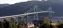
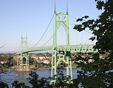
The St. Johns Bridge is a steel suspension bridge that spans the Willamette River in Portland, Oregon, United States, between the Cathedral Park neighborhood in North Portland and the Linnton and Northwest Industrial neighborhoods in Northwest Portland. It carries the U.S. Route 30 Bypass. It is the only suspension bridge in the Willamette Valley and one of three public highway suspension bridges in Oregon.[2]
The bridge has a 1,207-foot (368 m) center span and a total length of 2,067 feet (630 m).[3] It is the tallest bridge in Portland, with two 400-foot-tall (120 m) towers and a 205-foot (62 m) navigational clearance.[4] The adjacent park and neighborhood of Cathedral Park are named after the Gothic Cathedral-like design of the bridge towers.
History[]
Designed by internationally renowned engineer David B. Steinman (1886–1960) and Holton D. Robinson, of New York, the St. Johns was the longest suspension-type bridge west of the Mississippi River at the time of construction. It is the only major highway suspension bridge in the Willamette Valley and one of only three major highway suspension bridges in Oregon.
At the time of the proposal to build the bridge, the area was served by a ferry that carried 1,000 vehicles a day. The proposal for a bridge was initially met with skepticism in Multnomah County, since St. Johns and Linnton were over five miles (8 km) from the heart of the city, and local business owners had minimal political clout. But after a lobbying effort that included a vaudeville-style show performed at grange halls and schools throughout the county, voters approved a $4.25 million bond for the bridge in the November 1928 elections.[5] Initially, a cantilever bridge was proposed, but a suspension bridge was selected due to an estimated $640,000 savings in construction costs.[6]
The construction of the bridge began a month before the Stock Market Crash of 1929 and provided many county residents with employment during the Great Depression.[7] Because of its proximity to the Swan Island Municipal Airport, some government officials wanted the bridge painted yellow with black stripes. County officials waited until St. Patrick's Day 1931 to announce that it would be painted green.[8]
Dedication of the bridge was put off for one month in order to make it the centerpiece of the 23rd annual Rose Festival.[6] It was dedicated on June 13, 1931, and during the ceremony, the bridge engineer, David B. Steinman, said:
A challenge and an opportunity to create a structure of enduring beauty in the God-given wondrous background was offered us when were asked to design the bridge. It is the most beautiful bridge in the world we feel.[9]
The bridge was built within 21 months and one million dollars under budget. At the time of its completion, the bridge had:
- the highest clearance in the nation,
- the longest prefabricated steel cable rope strands,
- the tallest steel frame piers of reinforced concrete,
- the first application of aviation clearance lights to the towers, and
- longest suspension span west of Detroit, Michigan.
Eighteen years later, in the summer of 1949, 15-year-old high school student Thelma Taylor was abducted and held by her captor, Morris Leland, under the east side of the bridge (which was undeveloped at the time, now the location of Cathedral Park), and was eventually murdered there. The crime shocked the city and her killer was apprehended and put to death.[10]
It was not until the Marquam Bridge in 1966 that another non-movable bridge would be built in Portland.
By the 1970s, the bridge had been allowed to deteriorate, and cash-strapped Multnomah County asked the state to take over maintenance. Initially, the state declined, since it was also suffering from a lack of funds. But pressure from an association of county governments forced the state government to take it over on August 31, 1975. A county official estimated the move saved them $10 million during the first ten years of state maintenance.
Portions of the east approaches and east span were repainted beginning in 1987 and completed in 1994.
In 1999, the Oregon Department of Transportation announced a $27 million rehabilitation project that began in March 2003 and was completed in the fall of 2005. Included in the project was replacement of the deck, repainting of the towers, waterproofing the main cables, lighting upgrades, and improving access for bicycle and pedestrian traffic. By November 2004, renovation costs soared to $38 million, due mostly to the need to replace nearly half of the 210 vertical suspender cables. During the project, the bridge sidewalks were closed at all times. In addition, the entire bridge was closed at night and continuously for a month. The newly refurbished bridge was rededicated on September 17, 2006.[11]
In 2008, A sculpture installed at one end, 40 feet long,[12] housed a music box rendition of Hoagy Carmichael's Up a Lazy River which was popular the year of its dedication.[13]
In July 2015, a group of protesters affiliated with Greenpeace rappelled down from the bridge to prevent the icebreaker MSV Fennica from leaving Portland, because it was destined to help Shell Oil Company drill for oil in the Chukchi Sea. They stayed there for forty hours, prompting the icebreaker to turn around after an initial departure attempt a few hours into the blockade. The vessel did eventually get through after three climbers came down, although it was met by dozens of kayakers in the water who joined the effort to slow or stop the ship from moving forward.[14][15]
See also[]
References[]
- ^ "Historic Landmarks -- Portland, Oregon" (XLS). Portland Historic Landmarks Commission. July 2010. Retrieved May 8, 2016.
- ^ "St. Johns Bridge Rehabilitation Project". Oregon Department of Transportation. Archived from the original on December 20, 2006. Retrieved November 5, 2006.
- ^ "St. Johns Bridge Dedication". Center for Columbia River History. Archived from the original on May 9, 2016. Retrieved November 5, 2006.
- ^ Dwight A. Smith; James B. Norman; Pieter T. Dykman (1989). Historic Highway Bridges of Oregon. Oregon Historical Society Press. p. 113. ISBN 0-87595-205-4.
- ^ Carl Abbot (1983). Planning, Politics and Growth in a Twentieth-Century City. University of Nebraska Press. p. 99. ISBN 0-8032-1008-6.
- ^ a b "Written and Historical Data". Historic American Buildings Survey/Historic American Engineering Record. Archived from the original on June 30, 2012. Retrieved November 10, 2006.
- ^ Sharon Wood (2001). The Portland Bridge Book. Oregon Historical Society. ISBN 0-87595-211-9.
- ^ "Stumptown Stumper". Portland Tribune. August 31, 2006. Retrieved July 23, 2013.
- ^ "St. Johns: 1931". St. Johns Historical Gazette. Archived from the original on October 16, 2006. Retrieved November 5, 2006.
- ^ "Oregon's Next Executions Set". Eugene Register-Guard. January 5, 1953. Retrieved June 1, 2009.
- ^ "St. Johns Community Celebrates Rehabilitated Historic Bridge" (PDF). Oregon Department of Transportation. September 7, 2005. Retrieved November 22, 2006.
- ^ "Donald Fels - Cathedral Park". Artist Thinker. Retrieved March 12, 2017.
- ^ Janet Eastman (September 21, 2015). "The other side of St. Johns Bridge". Oregon Live. Retrieved March 12, 2017.
- ^ "Shell protesters rappel off St. Johns Bridge". Portland, OR: KOIN. July 29, 2015. Retrieved July 29, 2015.
- ^ Damien Carrington (January 7, 2015). "Leave fossil fuels buried to prevent climate change, study urges". The Guardian. Retrieved July 30, 2015.
External links[]
| Wikimedia Commons has media related to St. Johns Bridge. |
- Historic American Engineering Record gallery Includes pictures and detail drawings of notable engineering features.
- Saint Johns Bridge at Structurae
Crossings of the Willamette River | ||||
|---|---|---|---|---|
| ||||
- 1931 establishments in Oregon
- Bridges completed in 1931
- Bridges in Portland, Oregon
- Bridges of the United States Numbered Highway System
- Bridges over the Willamette River
- Cathedral Park, Portland, Oregon
- Portland Historic Landmarks
- Road bridges in Oregon
- Steel bridges in the United States
- Suspension bridges in the United States
- U.S. Route 30