Staňkov (Jindřichův Hradec District)
Staňkov | |
|---|---|
Municipality | |
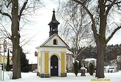 Chapel in the village | |
 Staňkov | |
| Coordinates: 48°58′14″N 14°57′31″E / 48.97056°N 14.95861°ECoordinates: 48°58′14″N 14°57′31″E / 48.97056°N 14.95861°E | |
| Country | |
| Region | South Bohemian |
| District | Jindřichův Hradec |
| Area | |
| • Total | 18.87 km2 (7.29 sq mi) |
| Elevation | 470 m (1,540 ft) |
| Population (2019)[1] | |
| • Total | 199 |
| • Density | 11/km2 (27/sq mi) |
| Postal code | 378 04 |
| Website | https://www.ou-stankov.cz/ |

Staňkov (Czech pronunciation: [ˈstaɲkof], German: Stankau) is a village and municipality (obec) in Jindřichův Hradec District in the South Bohemian Region of the Czech Republic, directly on the border with Austria.
The municipality covers an area of 18.87 square kilometres (7.29 sq mi), and has a population of 199 (as of 2019).
Staňkov lies approximately 21 kilometres (13 mi) south of Jindřichův Hradec, 36 km (22 mi) east of České Budějovice, and 130 km (81 mi) south of Prague.
References[]
- ^ "Population of municipalities of the Czech Republic". Czech Statistical Office. 1 January 2019.
| Wikimedia Commons has media related to Staňkov (Jindřichův Hradec District). |
| show Authority control |
|---|
This South Bohemian Region location article is a stub. You can help Wikipedia by . |
Categories:
- Villages in Jindřichův Hradec District
- South Bohemian Region geography stubs