Steinsel
Steinsel
Steesel | |
|---|---|
Commune | |
 | |
 Coat of arms | |
 Map of Luxembourg with Steinsel highlighted in orange, and the canton in dark red | |
| Coordinates: 49°40′35″N 6°07′25″E / 49.6764°N 6.1236°ECoordinates: 49°40′35″N 6°07′25″E / 49.6764°N 6.1236°E | |
| Country | |
| Canton | Luxembourg |
| Area | |
| • Total | 21.81 km2 (8.42 sq mi) |
| Area rank | 47th of 102 |
| Highest elevation | 373 m (1,224 ft) |
| • Rank | 71st of 102 |
| Lowest elevation | 241 m (791 ft) |
| • Rank | 47th of 102 |
| Population (2018) | |
| • Total | 5,321 |
| • Rank | 27th of 102 |
| • Density | 240/km2 (630/sq mi) |
| • Density rank | 31st of 102 |
| Time zone | UTC+1 (CET) |
| • Summer (DST) | UTC+2 (CEST) |
| LU0000308 | |
| Website | steinsel.lu |

Steinsel (Luxembourgish: Steesel [ˈʃteːzəl]) is a commune and town in central Luxembourg. It is located north of Luxembourg City.
As of 2005, the town of Steinsel, which lies in the west of the commune, has a population of 1,844. Other towns within the commune include Heisdorf and Mullendorf.

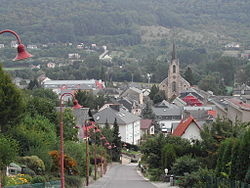
The church of Steinsel
References[]
External links[]
 Media related to Steinsel at Wikimedia Commons
| show Places adjacent to Steinsel |
|---|

| Authority control |
|
|---|
This article related to the geography of Luxembourg canton is a stub. You can help Wikipedia by . |
Categories:
- Steinsel
- Communes in Luxembourg (canton)
- Towns in Luxembourg
- Luxembourg canton geography stubs