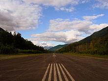
Stewart Aerodrome
Stewart Aerodrome | |||||||||||
|---|---|---|---|---|---|---|---|---|---|---|---|
 | |||||||||||
| Summary | |||||||||||
| Airport type | Public | ||||||||||
| Operator | District of Stewart | ||||||||||
| Location | Stewart, British Columbia | ||||||||||
| Time zone | PST (UTC−08:00) | ||||||||||
| • Summer (DST) | PDT (UTC−07:00) | ||||||||||
| Elevation AMSL | 24 ft / 7 m | ||||||||||
| Coordinates | 55°56′N 129°59′W / 55.933°N 129.983°WCoordinates: 55°56′N 129°59′W / 55.933°N 129.983°W | ||||||||||
| Map | |||||||||||
 CZST Location in British Columbia | |||||||||||
| Runways | |||||||||||
| |||||||||||
Source: Canada Flight Supplement[1] | |||||||||||
Stewart Aerodrome (IATA: ZST, ICAO: CZST) is a registered aerodrome located adjacent to Stewart, British Columbia, Canada. It shares its airspace with the nearby Stewart Water Aerodrome and Hyder Seaplane Base. While its neighbouring seaplane bases' water runways in the Portland Canal exist on the Canada–United States border, the aerodrome's runway exists entirely within Canada.
See also[]
References[]
External links[]
- Past three hours METARs, SPECI and current TAFs for Stewart Airport from Nav Canada as available.
Categories:
- Registered aerodromes in British Columbia
- Regional District of Kitimat–Stikine
- Binational airports
- British Columbia airport stubs
