Stewton
| Stewton | |
|---|---|
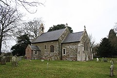 St Andrew's Church, Stewton | |
 Stewton Location within Lincolnshire | |
| OS grid reference | TF360867 |
| • London | 135 mi (217 km) S |
| District | |
| Shire county |
|
| Region |
|
| Country | England |
| Sovereign state | United Kingdom |
| Post town | Louth |
| Postcode district | LN11 |
| Dialling code | 01507 |
| Police | Lincolnshire |
| Fire | Lincolnshire |
| Ambulance | East Midlands |
| UK Parliament | |

Stewton is a village and civil parish in the East Lindsey district of Lincolnshire, England. It is situated about 2 miles (3.2 km) east from the town of Louth, in the Lincolnshire Wolds, a designated Area of Outstanding Natural Beauty. The population is included in the civil parish of Keddington.
In the Domesday Book of 1086 the village is written as "Stivetone", with of 19 households, 3 acres (0.0 km2) of meadow and 5 acres (0.0 km2) of woodland.[1]
The Grade II* listed parish church is dedicated to Saint Andrew and dates from the 11th century, although it was rebuilt in 1866 by James Fowler of Louth. In 1902 the west porch was added.[2]
References[]
- ^ "Stewton". Domesday Map. Anna Powell-Smith/University of Hull. Retrieved 8 August 2011.
- ^ Historic England. "St Andrews, Stewton (1359976)". National Heritage List for England. Retrieved 8 August 2011.
External links[]
 Media related to Stewton at Wikimedia Commons
- "Stewton Lincolnshire"; A Vision of Britain through Time; retrieved 4 June 2012
- "Stewton", Genuki.org.uk. Retrieved 4 June 2012
England Portal | |
| Unitary authorities |
|
| Boroughs or districts |
|
| Major settlements |
|
| Topics |
|
Categories:
- Villages in Lincolnshire
- Civil parishes in Lincolnshire
- East Lindsey District