West Keal
| West Keal | |
|---|---|
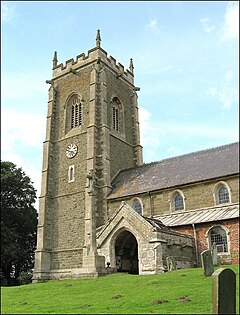 St Helen's Church | |
 West Keal Location within Lincolnshire | |
| Area | 8.10 km2 (3.13 sq mi) |
| Population | 327 (2011 census) |
| • Density | 40/km2 (100/sq mi) |
| Civil parish |
|
| District | |
| Shire county | |
| Region | |
| Country | England |
| Sovereign state | United Kingdom |
| Website | http://parishes.lincolnshire.gov.uk/WestKeal/index.asp |
West Keal is a village and civil parish 25 miles (40 km) east of Lincoln,[1] in the East Lindsey district, in the county of Lincolnshire, England. The parish includes the hamlet of Keal Cotes. In 2011 the parish had a population of 327.[2] The parish touches Bolingbroke, East Keal, East Kirkby, Mavis Enderby, Raithby and Stickford.[3]
Landmarks[]
There are 7 .[4] West Keal has a church called St Helen's Church.[5]
History[]
The name "Keal" means 'Ridge(s)'.[6] West Keal was recorded in the Domesday Book as Cale/Westrecale.[7]
References[]
- ^ "Distance from West Keal [53.150065, 0.043774]". GENUKI. Retrieved 10 December 2020.
- ^ "West Keal". City Population De. Retrieved 10 December 2020.
- ^ "West Keal". Ordnance Survey. Retrieved 10 December 2020.
- ^ "Listed buildings in West Keal, East Lindsey, Lincolnshire". British Listed Buildings. Retrieved 10 December 2020.
- ^ "St Helen, West Keal". A Church Near You. Retrieved 10 December 2020.
- ^ "East and West Keal Key to English Place-names". The University of Nottingham. Retrieved 10 December 2020.
- ^ "Lincolnshire T-Z". The Domesday Book Online. Retrieved 10 December 2020.
External links[]
| Wikimedia Commons has media related to West Keal. |
This Lincolnshire location article is a stub. You can help Wikipedia by . |
Categories:
- Villages in Lincolnshire
- Civil parishes in Lincolnshire
- East Lindsey District
- Lincolnshire geography stubs