Stopsley
| Stopsley | |
|---|---|
 Stopsley War Memorial | |
 Stopsley Location within Bedfordshire | |
| Population | 7,760 [1] |
| OS grid reference | TL103235 |
| Unitary authority | |
| Ceremonial county | |
| Region | |
| Country | England |
| Sovereign state | United Kingdom |
| Post town | LUTON |
| Postcode district | LU2 |
| Dialling code | 01582 |
| Police | Bedfordshire |
| Fire | Bedfordshire and Luton |
| Ambulance | East of England |
| UK Parliament | |

Stopsley is a suburb in the north-east of Luton, Bedfordshire, England. The area is roughly bounded by the edge of Luton to the north, Vauxhall Way and Turners Road North to the south, Bradgers Hill to the west, and Cannon Lane, Stapleford Road and Brays Road to the east.
Etymology[]
Frederick Davis, writing in 1965 believed the name of Stospley to come from Scrobbale, (in Saxon;) Scrapes or Scroppeslie, (in Norman;) Shrubsley, (in English.;) meaning a hill covered with scrobbes (shrubs or underwood.) Most modern etymologists consider the name to be made up of two elements 'Stopp' and 'ley'. dating between AD 750 and AD 950. The ending comes from the Old English 'leah' meaning a wood or clearing in a wood. 'Stopp' was a personal name and indicated ownership of the wood or clearing. It appears as 'Stopeslegh in Soca de Luton' in a (Latin) law record, dated 1440.[2]
Originally a hill-top village settlement, most of the urbanised part of the civil parish of Stopsley became part of Luton when the boundaries were extended in 1933, with the rural areas going to Hyde and Streatley.
Local area[]
The centre of Stopsley is made up of a variety of shops around a village church. From a distance the skyline is dominated by Jansel House, an office block built in 1961 which houses the Luton VAT office over a parade of shops at street level. One of Luton's two cemeteries, The Vale, is located nearby on the Hitchin Road.
Politics[]
Stopsley is part of the larger Stopsley ward which also includes Putteridge and part of Ramridge End. The ward is represented by Cllr David Wynn (Liberal Democrats) and Cllr Richard Underwood (Liberal Democrats).[3] The ward forms part of the parliamentary constituency of Luton South and the MP is Rachel Hopkins (Labour Party).

Local attractions[]
| Key | |
| Abbey/Priory/Cathedral | |
| Accessible open space | |
| Amusement/Theme Park | |
| Castle | |
| Country Park | |
| English Heritage | |
| Forestry Commission | |
| Heritage railway | |
| Historic House | |
| Places of Worship | |
| Museum (free/not free) | |
| National Trust | |
| Theatre | |
| Zoo | |
|
Education[]
Stopsley includes the specialist Sports College, Stopsley High School. Notable alumni include professional cricketer Monty Panesar. In the 1960s, Stopsley Infant and Junior School pupils included Alec Jeffreys, who went on to discover the DNA genetic fingerprint. He is now Professor of Genetics at Leicester University and was Knighted in 1994. Another pupil, David Renwick, created the television series 'One Foot in the Grave' and 'Jonathan Creek'. Both went on to study at Luton Grammar School and Luton Sixth Form College.
Gallery[]
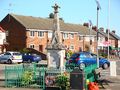
Stopsley War Memorial
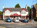
The Sportsman Public House in Stopsley
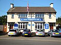
Luton Conservative Club in Stopsley
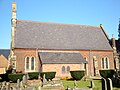
Parish Church of St.Thomas in Stopsley
Stopsley Common


References[]
- ^ Luton Borough Council, Population Estimates and Forecasts, estimate for Stopsley ward in 2007. The count in the 2001 Census was 7,105.
- ^ Plea Rolls of the Court of Common Pleas; National Archives; CP 40/717; http://aalt.law.uh.edu/AALT1/H6/CP40no717/bCP40no717dorses/IMG_1635.htm
- ^ "CMIS > Councillors".
Further reading[]
| Wikimedia Commons has media related to Stopsley. |
- James Dyer, The Stopsley Book, Book Castle, 2nd Edn. 2005, ISBN 1-903747-65-1.
- James Dyer, The Stopsley Picture Book, Book Castle. 2002, ISBN 1-871199-94-8.
- Keith T. Norcott, Chalk on my Shoes, Book Castle, 2006, ISBN 1-903747-68-6
- Wards of Luton
- Areas of Luton