Storžič
| Storžič | |
|---|---|
 View of Storžič from the Kalce Ridge | |
| Highest point | |
| Elevation | 2,132 m (6,995 ft) |
| Coordinates | 46°21′1.008″N 14°24′16.992″E / 46.35028000°N 14.40472000°ECoordinates: 46°21′1.008″N 14°24′16.992″E / 46.35028000°N 14.40472000°E |
| Geography | |
 Storžič | |
| Parent range | Kamnik–Savinja Alps |

Storžič (pronounced [ˈstɔːɾʒitʃ]; 2,132 meters or 6,995 feet) is the highest mountain in the western part of the Kamnik–Savinja Alps. The top is a nicely shaped cone (Slovene: storž), from which the mountain got its name. Storžič has a good panoramic view. To the south are the Ljubljana Basin, Mount Krim, the Javornik Hills, Mount Snežnik, the Nanos Plateau, and the . To the west are the Julian Alps with prominent Mount Triglav. To the north are the Karawanks with Mount Stol, Mount Begunjščica, and . To the east are the Jezersko Cirque, Mount Grintovec, the Kalce Ridge and Mount Krvavec.
Starting points[]
- Bašelj (Preddvor)
- Gozd (Tržič)
- Lom pod Storžičem (Tržič)
- Preddvor
- Spodnje Jezersko (Jezersko)
- Trstenik (Kranj)
Routes[]
- 4 h: from the Storžič Lodge (Slovene: Dom pod Storžičem, 1,123 meters or 3,684 feet), over Male Poljane via Psico
- 3½ h: from the Storžič Lodge (1,123 meters or 3,684 feet), over Škarjeve peči
- 3 h: from the Storžič Lodge (1,123 meters or 3,684 feet), through Žrelo, over Transverzala
- 1¾ h: from (1,534 meters or 5,033 feet), over Transverzala
- 4½ h: from (891 meters or 2,923 feet), passing
- 4½ h: from Spodnje Jezersko, over (Bašeljskiski vrh)
- 3½ h: from Trstenik, passing Velika Poljana or Javornik
- 3 h: from Bašelj, passing Koče nad Malo Pečjo over ridge on an unmarked route
External links[]
| Wikimedia Commons has media related to Storžič. |
| hide | ||
|---|---|---|
| Main peaks | 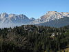 | |
| Authority control |
|
|---|
This Slovenian geography article is a stub. You can help Wikipedia by . |
Categories:
- Mountains of the Kamnik–Savinja Alps
- Mountains of Upper Carniola
- Two-thousanders of Slovenia
- Slovenia geography stubs