Grintovec
| Grintovec | |
|---|---|
 | |
| Highest point | |
| Elevation | 2,558 m (8,392 ft)[1] |
| Prominence | 1,706 m (5,597 ft)[1] |
| Isolation | 53 km (33 mi) |
| Listing | Ultra |
| Coordinates | 46°21′25″N 14°32′10″E / 46.35694°N 14.53611°ECoordinates: 46°21′25″N 14°32′10″E / 46.35694°N 14.53611°E[1] |
| Geography | |
 Grintovec | |
| Parent range | Kamnik–Savinja Alps |
| Climbing | |
| First ascent | 1759 by Giovanni Antonio Scopoli |
| Easiest route | Hike[2] |

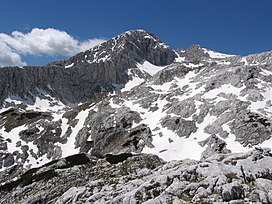
Grintovec is the highest mountain of the Kamnik–Savinja Alps, with an elevation of 2,558 metres (8,392 ft).[2] It is a popular location for hiking, climbing and skiing. The first recorded ascent was in 1759 by the botanist Giovanni Antonio Scopoli.[2]
Grintovec has a prominence of 1,706 metres (5,597 ft) and is therefore an ultra.[3] It is the second most prominent peak in Slovenia after Triglav.[1]
It is relatively easy to climb if you start from the lodge in the , via the Zois Lodge at Kokra Saddle.

Zois Lodge at Kokra Saddle
Routes[]
- 3h: From the Czech Lodge at Spodnje Ravni (Slovene: Češka koča na Spodnjih Ravneh) via (Mala vratca), then on the southeastern ridge (Dolga stena)
- 3h: From the Zois Lodge at Kokra Saddle (Slovene: Cojzova koča na Kokrskem sedlu) via the Roof Slope (Streha), the southern top slope of Mount Grintovec.
- 3½h: From the Czech Lodge at Spodnje Ravni via (Mlinarsko sedlo) on eastern ridge
- 3½-4 h: From the Czech Lodge at Spodnje Ravni on the (Dolška škrbina), then on the Šprem Route
References[]
- ^ Jump up to: a b c d http://www.peaklist.org/WWlists/ultras/EuroCoreP1500m.html
- ^ Jump up to: a b c "Grintovec". SummitPost.org. Retrieved 2008-09-16.
- ^ http://www.peakbagger.com/peak.aspx?pid=10163
External links[]
 Media related to Grintovec at Wikimedia Commons
- Grintovec. Map and virtual panoramas. Burger.si
- Grintovec on hribi.net Route Description and Photos (slo)
| show Authority control |
|---|
This Slovenian geography article is a stub. You can help Wikipedia by . |
Categories:
- Mountains of the Kamnik–Savinja Alps
- Mountains of Upper Carniola
- Two-thousanders of Slovenia
- Slovenia geography stubs