Snøhetta
| Snøhetta | |
|---|---|
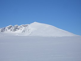 Snøhetta. From the left, the peaks are Vesttoppen, Hettpiggen, Midttoppen and then Stortoppen (highest) to the right. | |
| Highest point | |
| Elevation | 2,286 m (7,500 ft) |
| Prominence | 1,675 m (5,495 ft)[1] |
| Isolation | 82.7 to 82.9 km (51.4 to 51.5 mi) |
| Listing | Ultra, 3 at List of peaks in Norway by prominence, 24 at List of mountains in Norway by height |
| Coordinates | 62°19′12″N 9°16′6″E / 62.32000°N 9.26833°ECoordinates: 62°19′12″N 9°16′6″E / 62.32000°N 9.26833°E |
| Geography | |
| Location | Dovre, Oppland, Norway |
| Parent range | Dovrefjell |
| Topo map | 1519 IV Snøhetta |
| Climbing | |
| First ascent | 1798, Jens Esmark |

Snøhetta is the highest mountain in the Dovrefjell range, and the highest mountain in Norway outside the Jotunheimen range, making it the 24th highest peak in Norway, based on a 30-metre topographic prominence cutoff. Its topographic prominence is the third highest in Norway.
The mountain is inside Dovrefjell-Sunndalsfjella National Park.
The mountain has several peaks:[2]
- Stortoppen, the highest summit, 2,286 meters.
- Midttoppen, 2,278 meters, prominence 40 m
- Hettpiggen, 2,261 meters, prominence 50 m
- Vesttoppen, 2,253 meters, prominence 70 m
Vesttoppen and Stortoppen are easily available by hiking or skiing, and from Stortoppen Midttoppen is easily accessible. Traversing Midttoppen, via Hettpiggen and to Vesttoppen requires climbing with a rope.
On Stortoppen there is a radio link station, originally installed by the Norwegian Army, and now serving primarily civilian purposes. The station and its emergency diesel generator, as well as a nearby helipad, detract somewhat from the aesthetics of the summit. For this reason, many recommend Vesttoppen as a better destination.
A small monument for the Norwegian philosopher, humourist, author and mountaineer Peter Wessel Zapffe is located near the summit of Vesttoppen.
Under good conditions in both summer and winter, the ascent is relatively easy. Common starting points are the DNT-cabins Reinheim, Snøheim, or Åmotdalshytta.
History[]
Snøhetta was visited for the first time in 1798 as part of a scientific trip to the area. At that time it was assumed that was the highest summit in Norway, because the Jotunheimen area with its higher peaks was rather inaccessible and unresearched, while Snøhetta is visible from the traditional travel route Oslo-Trondheim across Dovrefjell. The expression "til Dovre faller" ('until the Dovre mountains fall') was used in the oath sworn during the Norwegian Constituent Assembly in 1814, when Norway formed an independent nation after being in a union with Denmark.
Etymology[]
The name is a compound of snø m 'snow' and the finite form of hette 'hood' – thus 'the mountain with a hood of snow'.
| Wikimedia Commons has media related to Snøhetta. |
References[]
External links[]
Guidebook[]
- A. Dyer et al. "Walks and Scrambles in Norway", ISBN 1-904466-25-7.
- Mountains of Innlandet
- Dovre