Grimming
| Grimming | |
|---|---|
 | |
| Highest point | |
| Elevation | 2,351 m (7,713 ft)[1] |
| Prominence | 1,518 m (4,980 ft)[1] |
| Isolation | 16.7 km (10.4 mi) |
| Listing | Ultra |
| Coordinates | 47°31′14″N 14°1′1″E / 47.52056°N 14.01694°ECoordinates: 47°31′14″N 14°1′1″E / 47.52056°N 14.01694°E[1] |
| Geography | |
 Grimming Alps | |
| Location | Styria, Austria |
| Parent range | Dachstein Mountains |

The Grimming (2,351 m) is an isolated peak in the Dachstein Mountains of Austria and one of the few ultra-prominent mountains of the Alps.


Geography[]
Location[]
The Grimming rises between the Enns valley and Salzkammergut, east of the Dachstein massif, being separated from its eastern rim by the .
Geology[]

Despite its topographical separation from the Dachstein, the Grimming is mainly made of Dachstein limestone and is, in effect, a slab of the Dachstein block that has broken off.
Southwest of the main summit is the Grimmingtor, a roughly 50-metre-high and 15-metre-wide recess in the rock face, capped by a 10-metre-thick rock overhang. To the east it is bounded by a large rib of rock, which is why, in certain light conditions, it has the appearance of a gate (German: Tor). According to legend, rich treasures have been hidden behind this "gate".
History[]
Thanks to its imposing appearance, it was long described as mons Styriae altissimus, the highest mountain in the Austrian state of Styria.[2]
Very early on the Grimming was used as a survey mark for land survey. In 1822 Lieutenant Carl Baron Simbschen erected a wooden survey mark at the summit and a stone hut just below it as a shelter.
Access[]
The mountain is a popular destination for mountaineers and climbers.
Huts[]
- Grimming Hut (966 m): The only hut in this massif is not far above the valley and may be reached in about an hour from Trautenfels.
- North of the Grimming summit there is a bothy that was built in 1949 and may be used as emergency shelter in bad weather.
Ascents[]
- From Trautenfels through the Schneegrube (southeast): most popular route via the Grimming Hut. This route was first used in 1888 by .
- From Kulm (northwest): starting behind the ski jump, through the cirque of Gipfelkar, where the bothy is located.
- From Trautenfels via Kasten and Multereck: this route initially crosses the eastern subpeak (2,176 m), before reaching the main summit.
- From Niederstuttern to the Grimming Hut, then left along the southeast arête or right via Kasten and Multereck to the top.
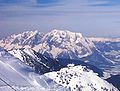
Gallery[]

Northwest view of the Grimmings
The Grimming from the

The Tressenstein and the Grimming from Pürgg

1908 photograph of Pürgg and the Grimming
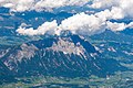
The Grimming in an aerial photograph, 17 August 2011


See also[]
References[]
- ^ Jump up to: a b c "Europe Ultra-Prominences". Peaklist.org. Retrieved 2012-10-29.
- ^ For example in the prints by Vischer.
Literature[]
- Paula Grogger: Das Grimmingtor. Literarische Aufarbeitung der Sagen rund um den Grimming. ISBN 3-222-11575-3.
- Josef Hasitschka; Ernst Kren; Adolf Mokrejs (2011), Universalmuseum Joanneum Schloss Trautenfels (ed.), Der Grimming. Monolith im Ennstal (in German) (1 ed.), Alland: Schall Verlag, ISBN 978-3-900533-69-4
External links[]
| Wikimedia Commons has media related to Grimming. |
| Authority control |
|
|---|
- Mountains of the Alps
- Two-thousanders of Austria
- Mountains of Styria