Hochtor
| Hochtor | |
|---|---|
 Hochtor viewed from the east | |
| Highest point | |
| Elevation | 2,369 m (7,772 ft)[1] |
| Prominence | 1,520 m (4,990 ft)[1] |
| Isolation | 20.8 km (12.9 mi) |
| Listing | Ultra |
| Coordinates | 47°33′42″N 14°37′58″E / 47.56167°N 14.63278°ECoordinates: 47°33′42″N 14°37′58″E / 47.56167°N 14.63278°E[1] |
| Geography | |
 Hochtor Location in the Alps | |
| Location | Styria, Austria |
| Parent range | Ennstaler Alps (Northern Limestone Alps) |

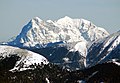
Hochtor, at 2,369 m (7,772 ft), is the highest mountain in the Ennstaler Alps, part of the Northern Limestone Alps, in Styria, Austria.
The mountain is protected as part of Gesäuse National Park, the third largest in Austria.
Gallery[]
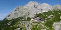
Hochtor with the Hesshütte, an alpine hut in the foreground
Hochtor - Ödstein Group (from right to left) as seen from Hoher Zinken in the south

Ennstal Alps from 10 000 m

View from Hochtor


See also[]
References[]
- ^ Jump up to: a b c "Europe Ultra-Prominences". Peaklist.org. Retrieved 2012-10-29.
External links[]
- "Hochtor". SummitPost.org.
- "Hochtor, Austria" on Peakbagger
| Authority control |
|---|
This Styria location article is a stub. You can help Wikipedia by . |
Categories:
- Mountains of the Alps
- Ennstal Alps
- Mountains of Styria
- Styria geography stubs