Gesäuse National Park
| Gesäuse National Park | |
|---|---|
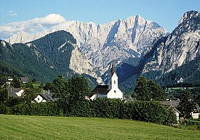 View from Weng into the Enns valley and the Hochtor massif | |
 | |
| Location | Styria, Austria |
| Nearest city | Graz |
| Coordinates | 47°36′0″N 14°45′0″E / 47.60000°N 14.75000°ECoordinates: 47°36′0″N 14°45′0″E / 47.60000°N 14.75000°E |
| Area | 110 km² 125 km² planned |
| Established | October 26, 2002 |

The Gesäuse National Park is a national park in the Austrian state of Styria. Located in the mountainous Upper Styrian region, it covers large parts of the Gesäuse range within the Ennstal Alps and the steep water gap of the Enns river between Admont and Hieflau. The area also covers parts of the municipal areas of Johnsbach, Weng, Landl and Sankt Gallen.
The national park currently covers 110 km2, with another 15 km2 planned. It was established on October 26, 2002.
The highest mountain is Hochtor at 2,369 m (7,772 ft).
External links[]
| Wikimedia Commons has media related to Nationalpark Gesäuse. |
| show Authority control |
|---|
Categories:
- IUCN Category II
- National parks of Austria
- Protected areas established in 2002
- Ennstal Alps
- Geography of Styria
- Tourist attractions in Styria
- 2002 establishments in Austria
- Protected areas of the Alps