Strážné
Strážné | |
|---|---|
Village | |
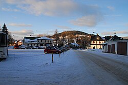 Center of the village | |
 Flag  Coat of arms | |
 Strážné Location in the Czech Republic | |
| Coordinates: 50°40′55″N 15°38′43″E / 50.68194°N 15.64528°ECoordinates: 50°40′55″N 15°38′43″E / 50.68194°N 15.64528°E | |
| Country | Czech Republic |
| Region | Hradec Králové |
| District | Trutnov |
| Little District | Vrchlabí |
| First mentioned | 1754 |
| Government | |
| • Mayor | Jiří Zlámal |
| Area | |
| • Total | 17.66 km2 (6.82 sq mi) |
| Elevation | 798 m (2,618 ft) |
| Population (2019) | |
| • Total | 226[1] |
| Time zone | UTC+1 (CET) |
| • Summer (DST) | UTC+2 (CEST) |
| Postal code | 543 52 |
| Website | www |

Strážné (German: Pommerndorf) is a village in the Czech Republic.
History[]
The first written mention of Pommerdörfl dates from the year 1754. The town has had mining operations since the mid-17th century, as there has been a miners' settlement and a stamp mill on the above the old Silesian Trail. The name of the village derives not, as a legend claims from local founders, but from the mining activity.
Strážné is a small community; nearby towns are (Friesbauden), (Hackelsdorf), (Füllebauden), (Gansbauden), (Teichhäuser), (Schöne Lahn), (Lahrbauden), Mlýnské Domky (Mühlberg) Well Výhlédach (Höhenschmiede), (Vorder Rennerbauden), Seidlovy Domky (Seidelhäuser), Šestidomí (Sächsstädten) and (Hinter Rennerbauden).
References[]
- ^ "Počet Obyvatel v Obcích - Population of Municipalities" (in Czech). Czech Statistical Office. p. 70. Retrieved 28 February 2020.
External links[]
| Wikimedia Commons has media related to Strážné. |
| Authority control: National libraries |
|---|
This Hradec Králové Region location article is a stub. You can help Wikipedia by . |
- Populated places in Trutnov District
- Villages in Trutnov District
- Stamp mills
- Mines in the Czech Republic
- Hradec Králové Region geography stubs